

Modfan2
-
Posts
2,327 -
Joined
-
Last visited
Content Type
Profiles
Blogs
Forums
American Weather
Media Demo
Store
Gallery
Posts posted by Modfan2
-
-
17 minutes ago, 40/70 Benchmark said:
Nice plot Ray; while at this moment I am too far east (pretty much on the I 95 sign above Palm Beach) for any major impacts other than rain and some breezy weather at this point.
-
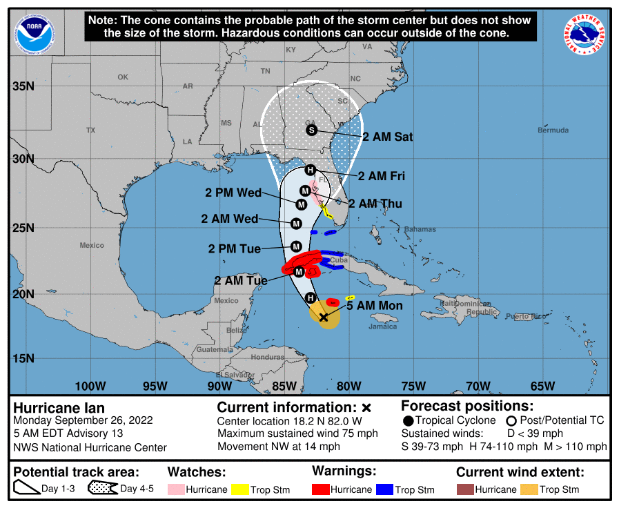
5am cone from NHC
-
 1
1
-
-
7 hours ago, Whineminster said:
CAT 2 seems NBD for FL, IMO. Even the rain seems to just sink into the limestone they don't seem to ever flood
During Irma parts of St Lucie County and neighboring Indian River counties received 21” and there was quite a bit of flooding.
-
1 minute ago, StantonParkHoya said:
Sure feels like some people wishcasting an east trend just to see mayhem for Tampa…
Plenty of members show a Tampa area hit, not sure I would call that “wishcasting”. Nothing is off the table at this point.
-
11 minutes ago, Floydbuster said:
The EURO shows this becoming a major hurricane, but not right away. 24 hrs from now it's still getting it's act together. That seems much more likely given how disorganized it is right now.
The GFS has this thing taking off immediately and being on it's way to Category 2 status 24 hrs from now. I'm skeptical of that.
Thus, I'm leaning towards the EURO model, atleast short term.
Most all models except GFS are around Tampa area
-
5am cone from NHC, S FL currently out of the cone; this can change.
-
3 minutes ago, WxSynopsisDavid said:
The global models did not have any but some of the hurricane and NOAA NHC in-house models had some dry air over the next 12-18hrs. However, even those runs didn't have the dry air significantly impacting Ian.
Would a slower development mean a more westerly track into the Gulf?
-
21 minutes ago, 40/70 Benchmark said:
I still say you want this is faster, and further south if you want an intense LF. I suspect a N GOM collapser if not.
Hope so, don’t want any part of it; a Tampa north LF is fine by me!!
-
9 minutes ago, GaWx said:
Right shift on 18Z ICON vs 12Z with Ft Myers to Daytona track
I would think, at this point that is the outlier?
-
1
-
-
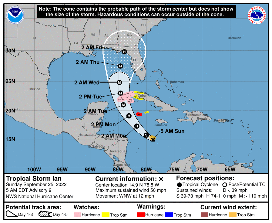
5am track
-
1
-
-
47 minutes ago, Damage In Tolland said:
Ryan says EPS very interesting for SNE for Ian
I mean why wouldn’t it, I close down here in 2 weeks and the few days later in CT….FML!
-
1
-
-
5 minutes ago, jrips27 said:
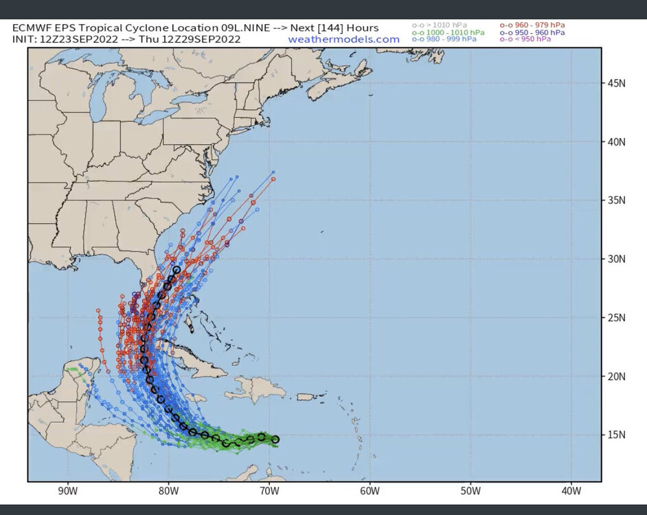
12z EPS tracks thru 144
Seems the quicker the right turn the weaker it is…
-
1 minute ago, madwx said:
the convection is tugging the center of the gyre and it seems to be heading due west now. Will have to keep an eye on how long it stays below 15 degrees. Most of the models hold it around the latitude until Saturday evening.
If it does I assume a further west track?
-
Just now, GaWx said:
12Z GEFS is significantly west of the last GEFS run and has the largest number of members well to the west in the central GOM since yesterday's 12Z run.
Is this due to the 2 centers of circulation, picking the further Sw as the main center?
-
1
-
-
Is the thinking still Sw to Ne on track where ever it makes landfall?
-
2 minutes ago, GaWx said:
The UKMET is almost always very conservative on forecasted storm strength especially during the early stages. This run actually never has it stronger than a TS and it's near its strongest during hours 132-168 of this run. So far, it hasn't has it stronger than 992 mb on any run. So, I consider the UKMET track much more informative than the intensity in most cases including now.
Wasn’t the Ukie the one that nailed the Irma track?
-
1
-
-
7 minutes ago, Ed, snow and hurricane fan said:
6Z GFS was at the extreme W end of the 6Z GEFS, or a shift East, especially if some added HH data ingested, would make sense. I hope Dr. Cowan makes another video today.
I would think we would need to see some model consistency over the next few runs to see the if this is a trend.
-
2
-
-
9 minutes ago, GaWx said:
Here's how I see it. Late Sept climo does not favor the good number of EPS members going NE across the S half of FL. That's more like mid Oct and later climo. But there's an Octoberlike upper trough coming into the E US days 4-6 before lifting out. Notice that the faster EPS members are mainly the ones that turn NE across S FL. So, it appears that a big key will be speed of 98L. If it goes faster, it will have a better chance to get caught by the upper trough and move NE over the S half of FL. But, if not fast enough, it very likely won't and would instead likely hit the N Gulf coast anywhere from the FL Big Bend westward to LA and probably at a slower speed.
Thinking your second scenario is more likely.
-
-
4 minutes ago, 40/70 Benchmark said:
My fear all along...or worse yet, central America...what a waste.
I’m good with that, I close down here on the 7th and that the last thing I need!
-
1
-
-
7 minutes ago, csnavywx said:
Yep, max layer shear stays 25-30kt for a good 48-72 hr before relaxing. Development will be slow and convection likely to be mostly relegated to the southwestern part of the circulation. Could easily see a south-of-forecast-track bias due to that shear.
There were quite a few members taking this into the Yucatán
-
20 minutes ago, jrips27 said:
A tick East and slightly quicker
This appears to be a reasonable track this early; a lot can and will change.
-
1
-
-
1 hour ago, Normandy said:
Euro is getting veeeeeeery close to Halifax with a 927 mb storm.
Not going to happen, you may see 940-945
-
 1
1
-
-
47 minutes ago, Hoth said:
Is it effed up that I'm jealous? I mean, I know a similar hit down here would probably put me in the dark for three weeks and require filing insurance claims and a whole lot of other headaches, but goddam I still want this beast.
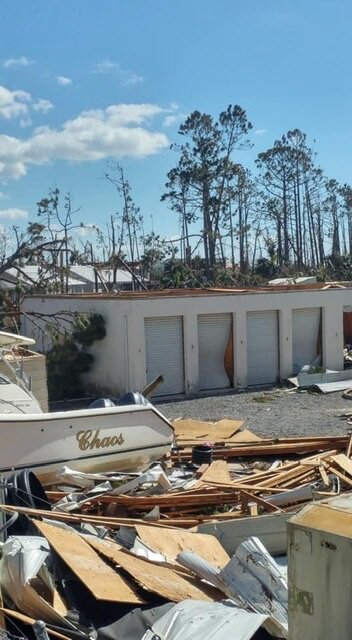
I spent 2 1/2 weeks in the FL Pan Handle for Michael and was enough for me to see.

-
2
-


Tracking the Tropics
in New England
Posted
Under a Tropical Storm warning now in SE FL.