

Modfan2
-
Posts
2,327 -
Joined
-
Last visited
Content Type
Profiles
Blogs
Forums
American Weather
Media Demo
Store
Gallery
Posts posted by Modfan2
-
-
48/44 and foggy to start!
-
1 hour ago, mreaves said:
Nice. Did you move back from FL?
Yes I did.
-
Five Mile River in the Ballouville section of Killingly

-
 5
5
-
-
20 minutes ago, Ginx snewx said:
Respect the Messenger shuffle. 1.43 total
Not nearly as much as you here, just west.
-
Looks like heaviest rain east into SE Ma, meh event so far.
-
Nothing like a welcome home front passage with some wind and rain!
-
Taylor Brook brewery/winery in Woodstock CT, downtown Putnam CT or Greater avoid Brewery in Worcester.
-
 1
1
-
-
Here’s my scientific take on winter with some observations from nature

-
1
-
-
Rainfall totals out of the NOAA Melbourne office.
-
1 hour ago, Ginx snewx said:
Coast Guard flying over Sanibel

Just like with Hurricane Michael, house with Metal Roofs can withstand a beating unlike shingle roofs
-
1
-
-
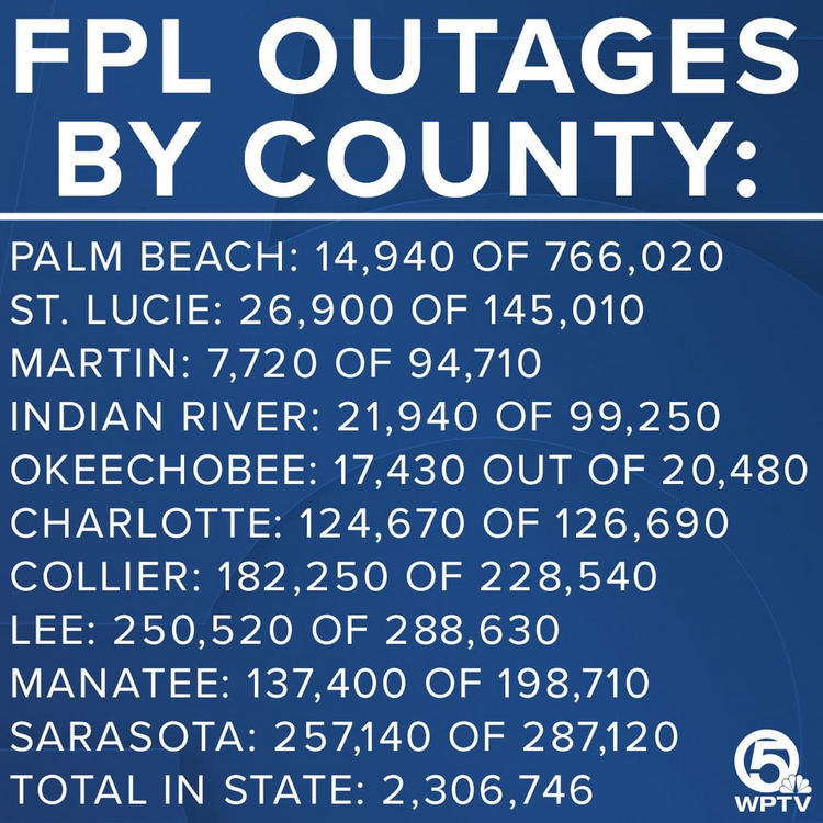
Florida Power and Light outages;
-
1
-
-
-
11 minutes ago, Damage In Tolland said:
Daylight is going to reveal unfathomable devastation
We are still getting decent TS gust here in Stuart after 6+ inches of rain and a few Tornado warnings Tuesday night into Wednesday; nothing compared to SW FL.
-
1
-
-
48 minutes ago, Cold Miser said:
Nice, Kev needs to wear this shirt for the next G2G
-
1
-
-
Had a few tornado warnings to deal with overnight here in SE FL, heavy rain band now; nothing compared to what SW FL is going to deal with.
-
3
-
-
4 minutes ago, Weather Mike said:
The latest Euro, CMC and GFS looked like it came a little North.
Looking on radar like it’s heading to Venice/Bradenton area
-
1
-
-
Looks like it’s heading N; when is the right turn projected?
-
1 minute ago, Treckasec said:
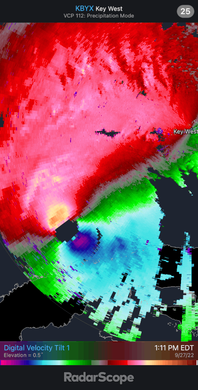
The radar at Key West appears to show a second wind region of strong winds organizing, which may mean that the moat is due to a new eyewall developing.
I would agree with you, just the west edge seems to be eroding which is concerning
-
13 minutes ago, MattPetrulli said:
Little bit of a moat after the southern eyewall. Thinking maybe a little dry air? Everyone free to chime in of course
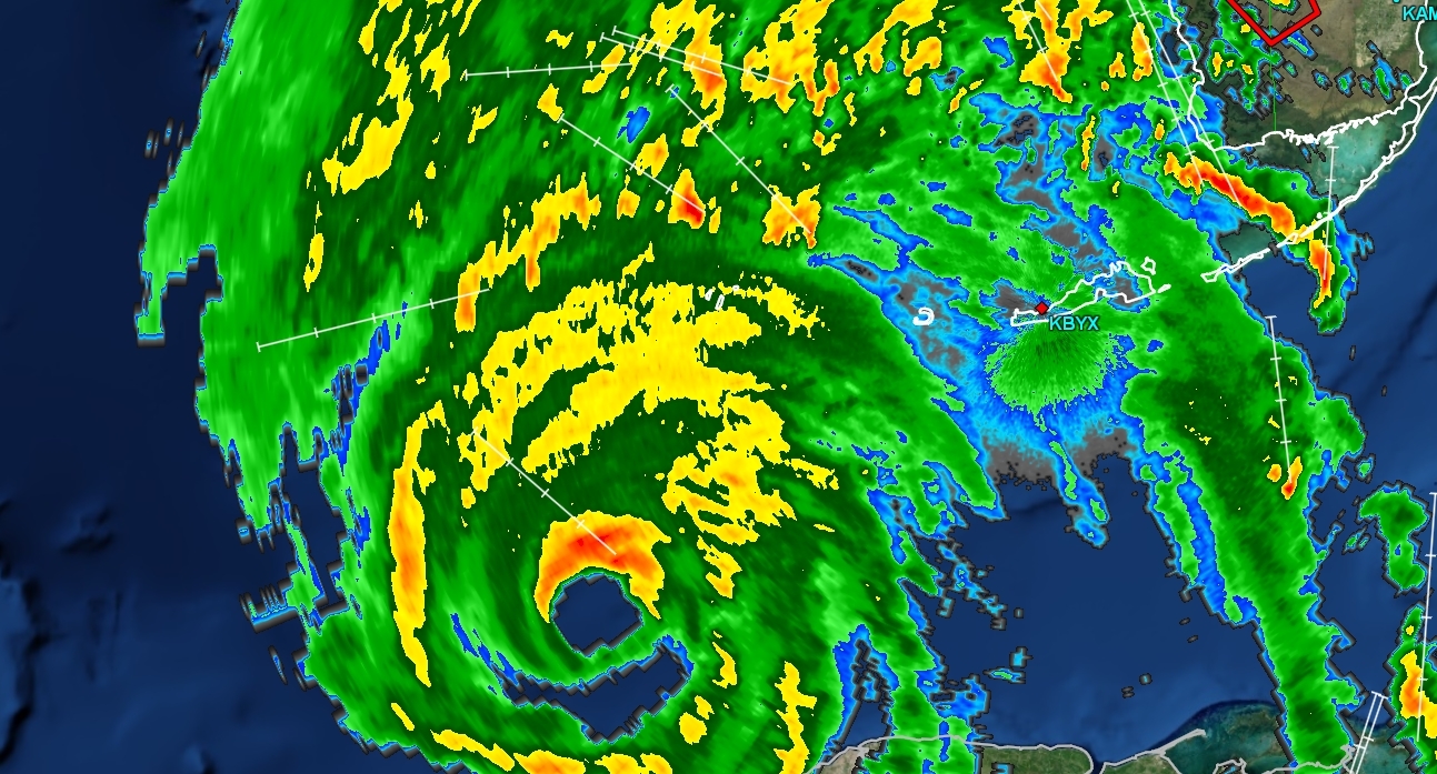
That’s what I was thinking earlier, radar out of Key West appeared to show dry air working in from west side
-
Question, watching the Melbourne radar, echoes pushing S to N seem to be dying out just north of West Palm; is there drier air coming from N?
-
Could be just the radar, but does it look like dry air is getting wrapped into the back side?
-
1
-
-
3 minutes ago, 40/70 Benchmark said:
Same page...my original thought on Friday was SW FL, and I may have overcorrected a bit yesterday to just N of TB.
I think this will end up between Venice and Sarasota
-
39 minutes ago, HoarfrostHubb said:
GFS is showing some 40" amounts oof
Where?
-
Tropical Storm warnings expanded here in SE FL


October 2022 OBS/DISC
in New England
Posted
34/33 to start, love this weather.