

Modfan2
-
Posts
2,327 -
Joined
-
Last visited
Content Type
Profiles
Blogs
Forums
American Weather
Media Demo
Store
Gallery
Posts posted by Modfan2
-
-
27 minutes ago, dan11295 said:
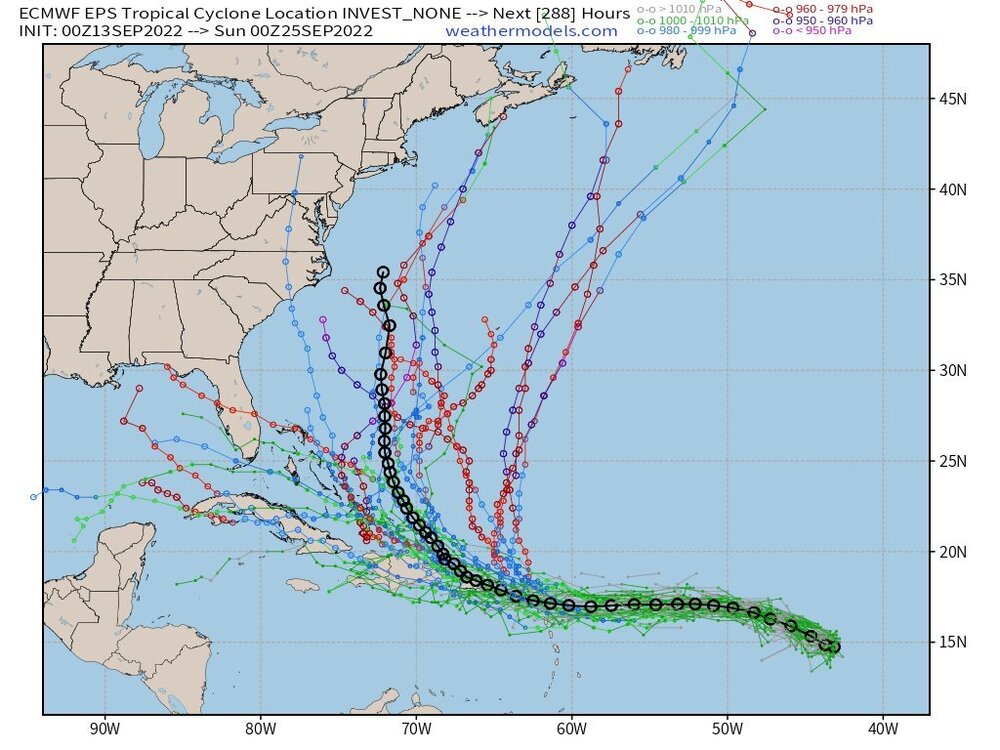
Been looking that at model runs and they have been trending gradually to the left with Fiona. Better for Bermuda, But increases impacts to Canada,
Wondering how far west this comes; initially heading into NF now Nova Scotia, is Downeast Maine in play?
-
48 minutes ago, Ginx snewx said:
200 km/hr gust is 125mph wow and look at the coverage. Nova Scotia
Keeps ticking west, Downeast Maine still in the game
-
 1
1
-
 1
1
-
-
1 minute ago, WinterWolf said:
It sure does…we need Fiona to get her arse up here for an intimate visit.
I mean, a storm of that magnitude I wouldn’t want in New England; have said it before with the tree growth over the last 30 years two week power outages will the minimum.
-
 1
1
-
-
40 minutes ago, CoastalWx said:
Because for a mean, I find MSLP to be noisy. Seems like H5 vorticity is a better proxy for mean anyways. But, I would like to see the tracks to get the best idea.
Let’s see if it holds together in the next 48 hours
-
28 minutes ago, wxeyeNH said:
12Z GFS is beautiful if you want a strong New England hurricane. Storm intensifies as it moves north over the gulf stream High pressure to our east blocks it from escaping out to sea. Trough comes in from the west and yanks it northward. Long Island up the Connecticut River. Only 270 hours away.

Lock it Lol! That’s a James storm if I ever saw one!
-
 1
1
-
-
Always looking towards trends with weather I wonder how the FL east coast cities from Vero to West Palm being very dry (13-15”) for the year correlates to any analogs years for Hurricane season.
This has been as dry a rainy season we have had in the last 10 years along the I 95 corridor and we are 3/4 of the way through.
-
ECMWF suite appears to support recurve north; something to watch for here?

-
2
-
-
ECMWF suite appears to support recurve north; something to watch for the East Coast? Maybe discounting strength of ridge and allowing for a turn north.

-
1
-
 1
1
-
-
ECMWF suite appears to support recurve north; something to watch for the East Coast? Maybe discounting strength of ridge and allowing for a turn north.
-
1
-
1
-
-
Rotation down on S RI coast with that cell?
-
Meanwhile here in S FL it’s non stop torch!

-
1
-
2
-
-
15 hours ago, Damage In Tolland said:
Just a furnace right thru months end on all guidance ( relative to normals)
Define furnace?? It’s been 92-94 here every day for a few months now with limited rain. Looking forward to NE “furnace” weather in about a month!
-
1
-
-
Do any of you heat with Propane? Purchasing a house that is propane heated and looking for feedback.
-
4 minutes ago, Ginx snewx said:
Holy shit 4.52 now

I’m just north of you in Attawaugen section of Killingly and not doing much
-
15 minutes ago, jbenedet said:
Coming back home to Dover NH from eastern Long Island. On the cross island ferry right now, about halfway from new London. Will be arriving in new London in 30 min. Pissed seeing the training and flooding. Not sure if I’m worse off going 395 from new London or through providence on 495.
Don’t see many pics of 395 flooding, 95 in Providence is a mess
-
1
-
-
2 minutes ago, Damage In Tolland said:
Mossup is going to be close to ground zero. Look at that radar lining up to run a choo choo on him . He’s already reporting street flooding on his hilltop
Some decent flooding pics out of Providence; RI could be ground zero
-
3
-
-
4 minutes ago, ORH_wxman said:
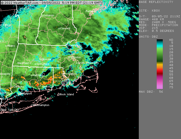
Any Seabreeze enhancement or is it a CF?
-
Congrats RI and Se Ma?
-
Heaviest just NE of PF in Thompson/Dudley/Webster
-
1
-
-
Is this going to be one of those FL thunderstorm deal where you sit under a cell get a quick 1-4” and that it?
-
Were about to go from drought stricken videos from inside the Yantic River in SE CT to banks overflowing in Norwich and basement pumping if those models verify!
-
23 hours ago, powderfreak said:
Was there today too, ha. Photo looks familiar.
Fantastic day for it. French Fries and Del’s Lemonade for lunch. When in the Fair… first time in probably 15 years after going every year growing up.

Could have done a forum GTG there or at Taylor Brook Brewery.
-
1
-
-
On 9/3/2022 at 3:46 PM, Cold Miser said:
Woodstock Fair.


It was hot today, yesterday much nicer!
-
2
-
-
26 minutes ago, powderfreak said:
Never going to even know who Stein was by the end of the warm season… all that drought talk for naught at the end of the day? Like a couple rainers away from Flood Watches if this pans out.
EURO and GFS and GGEM.


Thinking the GGEM looks more realistic.


Hurricane Ian
in Tropical Headquarters
Posted
Looks like many members into the Yucatán