

Modfan2
-
Posts
2,327 -
Joined
-
Last visited
Content Type
Profiles
Blogs
Forums
American Weather
Media Demo
Store
Gallery
Posts posted by Modfan2
-
-
8 minutes ago, CoastalWx said:
I didn't see anybody locking that in or anything, just a comment on what guidance showed. I think we all understand it's a low chance.
While in no means a lock, this morning’s run and this are trending better than we were yesterday.
-
 1
1
-
 1
1
-
-
Just now, RUNNAWAYICEBERG said:
There’s nothing else we can do but reframe our thoughts. Some of the youngins who have not gone through bad winters, especially, could use a little humble pie.
Sort of like a bad Patriots season, young people have no idea who Grogan, Eason, and Millen are lol!
-
1
-
-
4 minutes ago, Typhoon Tip said:
Not to be a dick but… the idea of this wave event splitting into two has been on the charts in more or less suggestion for the past week, actually. It’s not so new. I suspect we’re just getting around to noticing it.
I kind of miss lead people myself because I thought the the lead wave was really a warm advection burst or thrust pushing up through New England. But now that it some time’s gone by the models caught back up with that thinking it looks more likely that it’s just lack of cold air in the antecedent setting is causing the storm to mature a cyclone prematurely relative to the trough amplitude. That shears from Ohio through the St. Lawrence seaway.
But the actual better trough amplitude happens later and that’s what the GGEM and EURO are picking up on. An idea that the 06ZGFS actually hinted a little bit towards doing also with flashing over the Greens with a late wave development
Some of the EPS showed backside change from Poconos up through W CT and Mass up into NNE, still think this is plausible?
-
Thought EPS members looked better this am for CNE/NNE peeps
-
27 and light snow in Brooklyn CT, maybe a coating
-
2
-
-
This sums up the Tenor here in the last few weeks, and quite possibly one of the top 5 live performances ever!
-
2
-
-
5 minutes ago, HoarfrostHubb said:
Colder solution than 0z. Still not enough for SNE. But better
I am not expecting any snow out of this, but your area north is still in the game
-
1
-
-
3 minutes ago, dryslot said:
You can tell by some of the comments that they didn't look at models, All the ones that went out that far has snow for some in NNE, I'll stand by my comment from yesterday, Someone's going to get crushed and right now, A few areas look to be favored especially the elevated ones unless this ends up tracking to BGM.
I have no hope other than a slim chance at a coating; northern ORH into C/NNE are areas that could make out
-
1 minute ago, Sey-Mour Snow said:
End of the run but we take. Better than showing the alternative. And it’s been consistently getting better in long range.
Was think the same, seeing ticks in the right direction; see if this trend continues.
-
Didn’t Kiss right a song about storms like that, Cutter!
-
My daughters friends from FL coming in this weekend, hoping to catch some snow. Hopefully Wawa or Ward Hill will have some left
-
Here comes the black ice
-
Nice band on 395 at MA/CT line down into Thompson and Putnam
-
Nothing like some snow mixing in with the rain to kick ya in the Jimmy at the end of this event!
-
Snow mixing with rain in Brooklyn CT
-
Hoping when that heavier stuff on LI get here we have cooled off, currently sitting at 37
-
2 minutes ago, WinterWolf said:
Ya most are done in CT. Places like Stafford maybe grabs an inch later..maybe? But the rest of us are done.
Next. If there is a next lol.Stafford, Union, and higher points of Woodstock and Thompson might get up to 2”
-
Just now, ORH_wxman said:
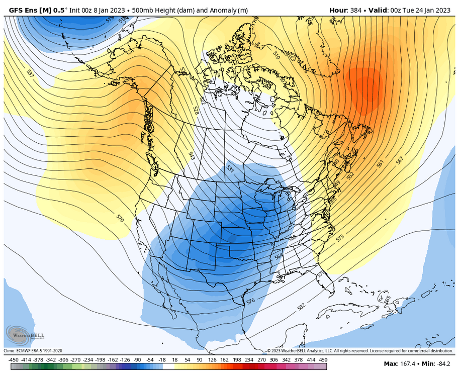
Most day 9 potential storms don't work out so it wouldn't be surprising. But who knows...maybe something else breaks favorable like Monday or the 1/11 system comes back from the dead.
I think we see something in the 11th-16th time frame.
-
Stuck at 35 and rain.
-
No rain yet and 35.
-
16 minutes ago, CoastalWx said:
GEFS look good to me for both signals. Again, all you can ask for.
Start a thread lol?!?!
-
1
-
 1
1
-
-
25 minutes ago, CoastalWx said:
Enjoy wearing shorts today. Jelly.
I mean NNE fetch here I haven’t budged above 44 since 530a.
-
17 minutes ago, Baroclinic Zone said:
00z Euro had 60s in CT.
It was 56 in sections of W CT this am so 60’s not out reach
-
1
-
-
43 with cool air holding on here in the Quinebaug valley; not as much drain as the CTRV.

January 2023 Obs/Discussion
in New England
Posted
Here’s a recent pic