

Modfan2
-
Posts
2,358 -
Joined
-
Last visited
Content Type
Profiles
Blogs
Forums
American Weather
Media Demo
Store
Gallery
Posts posted by Modfan2
-
-
Just north of me in West Woodstock starting to get a pretty good coating of ice
-
34F here in Brooklyn, plain rain and winds out of the W/NW at 4 so no drain here yet.
-
19 minutes ago, Damage In Tolland said:
Lots of ice here . Stayed 30-31 all night
Congrats, 33 and rain here
-
And…..dry slotted! When does the lawn thread start?
-
 3
3
-
-
-
Light snow now and 39F in Brooklyn
-
40F and cloudy in Brooklyn
-
2 minutes ago, ORH_wxman said:
Rap gone wild north of the pike.

Think it’s onto a colder solution the other models aren’t picking up on?
-
2 minutes ago, Typhoon Tip said:
DP's are chilly though.
lot of 40/21's around. The typical 5/9ths ~ WBs at 32 ish.. heh
Temp here 42 with DP of 21
-
3 minutes ago, dryslot said:
Another winter stretch inbound.
For some!
-
5 minutes ago, ORH_wxman said:
3k is more aggressive with the tuck than 12k. Brings BOS below freezing by midday Thursday
Sleet into NE CT/NW RI
-
1 minute ago, Ginx snewx said:
Depicts frozen line further south. Look at PA especially as that is closest to go time. Based on that wagons south for Nam
What does that mean for us?
-
5 minutes ago, CoastalWx said:
The mesos albeit initially too warm I think have the right idea. Although I definitely would have some snow and ice inside 128 and that tuck tomorrow may cause issues.
Just saw the 6z nam and that isn’t backing down.
I’m thinking my 250’ elevation is going to hurt me down here vs Ginxy with elevation and might stay frozen longer. Expecting a coating of snow some sleet, freezing rain then plain rain
-
1 hour ago, HoarfrostHubb said:
Euro with a warning event for some
Rain for many lol!
-
11 minutes ago, SnoSki14 said:
2nd half of March will deliver in SNE. NAO response + rapidly shortening wavelengths equal snow potential.
There's already hints of this in the LR OP runs.
There’s been Hints since December.
-
 1
1
-
-
7 minutes ago, CoastalWx said:
I would love 80 at this point.
Agree!
-
Light rain and 37F.
-
This looks better, congrats Ginxy!
-
3
-
-
2 minutes ago, ORH_wxman said:
Starts ripping in CT by midnight or so. Could be an interesting sensible wx shock…people grilling dinner at 55-60F in CT this evening to parachutes falling with several inches already OTG when they wake up.
Other mesos continue to be a bit more tame but they still have it. More like 1-2” or so.
Patiently waiting to see what it looks like tomorrow am
-
5
-
2
-
-
30 minutes ago, CoastalWx said:
Easy to say when you'll be knee deep in powder. But I get it.
Exactly!
-
13 minutes ago, ORH_wxman said:
Icon actually came in a decent tick colder. Has a nasty cold tuck over eastern areas too…temps crashing into 20s. That’s prob the top hazard in SNE…flash freeze potential for the areas that go from a quick burst to snow to IP to cold 34-35F rain but then it quickly falls to 27F with little notice.
Still a possibility this ends up as mostly a sleet bomb too after an inch or two of snow.
It’s been consistent with a back door like cold tuck in Emass
-
5 minutes ago, CoastalWx said:
Here comes the warmer moves.
Tip starting a thread has been the kiss of death this season for SNE.
-
1
-
 1
1
-
-
Bottoming out at 46F this morning.
-
2
-
-
Fully expecting down here a cold rain which is fine by me; wash any residual sand or salt from the roads and ready for Spring!
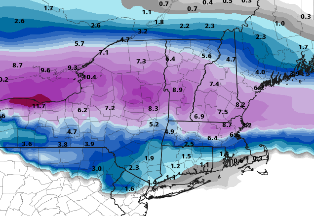
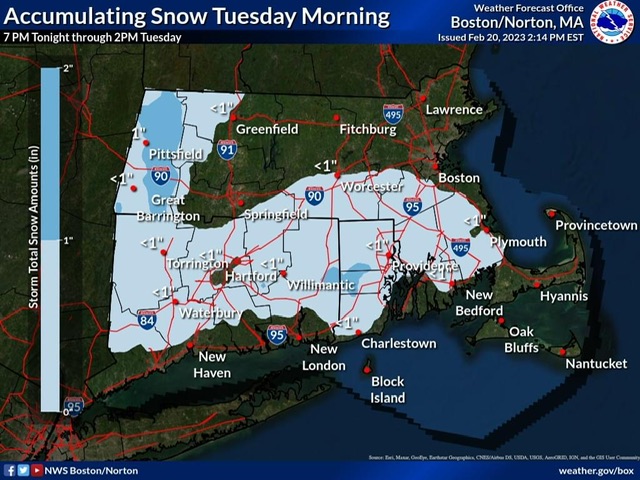
Nowcast and obs for Wednesday evening through Thursday night's wintry mix storm event.
in New England
Posted
Temp rose to 35 here but wind has shifted to NNE, let’s see how quick we cool