
Ogmios
-
Posts
109 -
Joined
-
Last visited
Content Type
Profiles
Blogs
Forums
American Weather
Media Demo
Store
Gallery
Everything posted by Ogmios
-
Western Nova Scotia gets whiffed and Halifax gets nipped. By tomorrow if the trend continues I can say the trend is looking kind of locked for a miss.
-
The trend is Newfoundlands friend: Even now Nova Scotia maybe trending out of the picture, so we will see what the other models say.
-
Well I am no expert on that but what I do see is a quick do you see me and now you do not 3-4 day scenario and at the end of the 12Z a weak potential with the 10 mb. But again I am just a cartographer that gives me some slight map interpretation skills that you may or may not have; and that is your area of expertise I assume. So you will have to take that with him, still it is both fun and frustrating watching the plan of nature come together.
-
Joe Cioffi says it is not the Pacific, it is the Arctic being locked away that allows for the opportunistic Pacific to dominate.
-
Slight western shift this morning on the 6Z now gives all of Nova Scotia a major snow storm with even SE New Brunswick getting in on the fun, but unfortunately for Shelburne County it is enough for a changeover to rain. So where we are closing in on the 50 hour mark this track of this storm is almost a lock with still some variability. Putting a blizzard special on order towards Boston but I do not know if it is even possible given the state of the AO+ with the opportunistic Oceans. Some British meteorologist if he is one call this the pest from the west.
-
What is consistent is that along with the February 2 time frame that is being watched attention could shift to February 9 as the model keeps producing this low in several consecutive runs that seem to amp this storm that wants in most runs to bring a significant snowfall event to someone along the coast. It is still way too early and could wiff into the wind so easily that hearts in Boston might break especially with comical fantasy but hoped for those kind of amounts that would shutdown SE New England on a whim.
-
ICON has advanced enough to send a message "It's gonna rain."
-
I hope you get crushed with 40 cm of snow and blowing snow down Halifax, and I will be happy with 15-20 cm. So I will call it hoping for a Blizzard Warning the first in what? Three or four years? It has been awhile and quite honestly we are overdue for a storm of that caliber.
-
6Z has no phasing with the northern energy until Eastern Nova Scotia which is OTS (Out to Sea) for most areas except said area.
-
Storm on the 6Z looks better for New England with the Nova Scotia Coastal huger on this run with Hazey doing okay but going to a messy rain with Halifax and east rain and Truro west snow and ice split.
-
Cannot predict the final result for the month of February but could end up not so much epic but likely more salvageable in terms that the month might provide closer to normal snowfall and maybe slightly above temperatures. Noticing the trend my thoughts is that March is likely the month that we get a normal to slightly below normal. But some will likely continue snow-less.
-
Except for a two day period within the last two and a half weeks in most of Nova Scotia we have been extremely lucky to go through such a good period of snow accumulation in such a pattern not conducive to snow, it came down to luck but we are still on a general trend of ending on a below average season for many areas the 3rd straight season. The further south you are the more likely you will still have below average snowfall for January alone. If anything excites me regarding this pattern is that if I wish to I can certainly get out my Georgraphic Information System (QGIS) and plot out the temperatures and overall precipitation amounts. And what disappoints me is the awful tracking of recent historical records that are in my opinion not tracked very well regarding snowfall, as if plotting only snow cover; you do not account for gained snowfall prior to changeovers to rain which is melted the next day. Kentville reported 2 cm on the ground on Christmas Day but the surrounding area outside the research station was largely bare and therefore that is false information to conclude a white Christmas for the area.
-
Near Ground Hog Day if there is one ounce of truth to the myth it does have a psychological effect on the psyche of people and for most people who have an utter dislike for the cold this is the one day you do not want it to be sunny on the 2nd. Especially in such a bad pattern for all sides because of it being to warm and wet for cold air snow lovers and too wet for warm air and lovely Spring type conditions that support growth and lots of vitamin D (those who despise cold and snow which is the majority); no party has been happy this winter. But if this trend continues winter lovers will take another blow for the winter psychologically, while the other side gets a nice dopamine hit looking forward for warmer days. The suggestion on the GFS of a system has been consistent for this time period.
-
The low is tracking further to the south compared to the previous run. So why declare defeat already over 130 hours out? And even if it turns out to be a non winter as it has been for so many mother nature made that decision to balance out the over abundance of snow that occurred in more consecutive recent winters. We could all go through this again next winter. Or maybe just some of us. Either way mother nature does not care about our feelings.
-
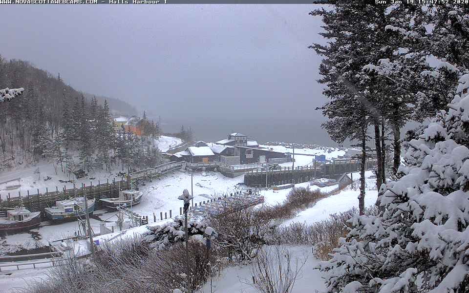
A winter wonderland picture perfect in nearby Halls Harbour: -1.1°C / 30.1°F
-
About 5.1 inches so far in my area of the Valley which the European model came out to be a lot more accurate then the under performing GFS which called for 1 to 2 inches.
-
The storm of 2020! Who knows but as I recall White Juan - now that was a winter hurricane that hit us back in 2004 that because it did not hit the states was never named the Blizzard of 2004. Interestingly enough this winter seems to be the winter that comes in spurts for Newfoundland, even for parts of Nova Scotia specifically for Cape Breton, (mainland is in a bit of a 2nd and in some cases 3rd year in a row snow hole) as for most of Southern New England it will be the second season in a row of being in that snow hole. Interestingly enough in storms like this if the NAO was negative this is a major rain storm for you, with the teleconnections that are good down there can be bad in Newfoundland. In a true GSM temperature wise Newfoundland is likely to be warmer.
-
Fast flow on the 6Z indicating Pacific dominant flow EPO+ continuing with with an AO+; with nothing but higher heights (500 Anomaly) on the map in fantasy land. CFS is also being schooled by the EURO as the latest still shows overall cold until you get into Maine and up into the maritimes which show blow torch; expect the trends to continue to go warm at this point for all of North America.
-
I keep hearing from 3rd party sources that the European models have recently trended into a blow torch pattern for much of the East Coast throughout February which is in agreement with the CanSIPS. Since I do not have access to the Euro long term predictions by monthly I will leave that to others to verify whether true or not.
-
I would also say some people just like to make a living off it (snow plow drivers), and small businesses that need the income to supplement the seasonal industry facing the everyday struggle that might cause closure and failure through things unrelated to weather that will not be mentioned here, and not enough customers requiring equipment for winter activities and tools alike; the season might end up so slow that more workers lose their jobs.
-
From Judah Cohen: GFS ensembles now in agreement w operational completing a troposphere-stratosphere-troposphere coupling strong #PolarVortex/positive Arctic Oscillation (AO) event with positive AO predicted for late Jan & early Feb that favors an overall mild pattern across the N Hemisphere: Better get ready in some areas at least to plan on some early gardening should this verify as the correct solution. Dr. Dews will be doing his rain dance no doubt to help this along.
-
GFS has a complete cutter going way further to the north and is no longer a by of Fundy Track but a central New Brunswick one with a longer duration of rain though not looking very intense as the precipitation looks along the lines of late December 2018 and early January 2019 type of weak system. That thump is looking less likely and is more of a straight out mild air event. I am still surprised that the highs are still only 37 degrees but I am expecting 40's as a probability and general snow lovers defeat as models continue to trend warmer, which leads me to think this storm is looking like more snow for Quebec, Northern New Brunswick, and Northern interior New England.
-
Not sure if this should be posted over on the panic forum for those that will not like the Pacific look in these teleconnections: The NAO is not bad, the PNA is good shape, but the EPO says ocean runaway influence. Note: if you are getting the 14th of January please click on the image to get the January 15 teleconnections
-
The GFS argues for the runner with no secondary low development while the European develops one. The CMC agrees with the GFS while the ICON agrees with the Euro. So which model is schooling whom, and based on the overall synopsis of the general pattern overall in the outlook it is increasingly clear the ocean climate so to speak as opposed to a more Arctic look is not going anywhere's anytime soon though it may somewhat be suppressed allowing for regular chilly air shots more for Northern New England as that ridge in the Atlantic is going to keep fighting back.
-
Pretty bad when Vancouver gets more snow then Connecticut but I have no doubt that the Blizzard of 2020 will hit your area and miss mine to the south by the middle of February.