

Dsty2001
-
Posts
372 -
Joined
-
Last visited
Content Type
Profiles
Blogs
Forums
American Weather
Media Demo
Store
Gallery
Posts posted by Dsty2001
-
-
Still there on 6z, would be a nice little event if verified

-
 2
2
-
-
Looks like a broad 3-4 across NE TN with higher amounts but I have no idea how to zoom in on tropical lol
-
1
-
-
3 hours ago, Carvers Gap said:
Man, the ground here is barely unfrozen. I still see ice on small creeks where I run. The ground is not warm at TRI..maybe extreme south facing slopes, but otherwise, the ground is super cold.
Typical MRX statement, a few days of warmth automatically correlates to = warm ground temperatures.
-
1
-
 1
1
-
-
I would take that and be happy for the next couple winters if verified lol
-
1
-
-
Wth woke up to the heaviest snow I've seen in a long time, roads and everything are covered
-
3
-
1
-
-
35 minutes ago, Math/Met said:
This current band has easily the heaviest rates of the night for me. Blowing around too.
I just walked outside to some very heavy snowfall, roads are covered!
-
2
-
-
Still snowing in Greene Co, also the winds are picking up
-
2
-
-
Absolutely puking snow right now in Mosheim, roads are already covered
-
4
-
-
Snow starting to stick in Greeneville/Mosheim
-
2
-
-
Future radar on multiple sites showing snow moving back into east TN around 1-2pm and lasting till about 7, would be nice if that comes to fruition
-
3
-
-
Wasn't most of the east valleys totals supposed to come from later today/tonight anyways?
-
4
-
-
Also to note, had to run out about an hour ago and the tires were spinning some, so it's getting slick on the roads already
-
1
-
 1
1
-
-
ripping fatties in Greene co between mosheim/bulls gap
-
4
-
-
Snowing here in Greeneville surprisingly
-
1
-
-
36/31 here right now, think i'm already lower than the hourly forecast was showing
-
Just don't see the low travelling in the way the HRRR is depicting it
-
2
-
-
Huge improvement over the last run, I still have a feeling this storm is going to surprise us
-
1
-
 1
1
-
-
Wonder if with this new information MRX will start issuing advisories/watches further east, even if you go by the worst models can't believe they've not at least issued a WWA for the eastern counties
-
I just...these model runs are??!?! At this point I'm about to stop looking at them, cause I think they are as confused as I am lmao
-
1
-
1
-
-
I will say judging by radar returns in the midwest, this system looks pretty robust
-
3
-
-
With as fickle as this system is I wouldn't throw the towel just yet.
-
1
-
-
Yeah i'm not throwing in the towel just yet. Seen too many times models readjust 12-24hrs prior and with a system like this, minor adjustments can lead to some interesting changes.
-
2
-
-
I still can't for the life of me figure out the placement for the LP. It goes all over the place and even goes back NW at one point
-
32 minutes ago, John1122 said:
The NAM doesn't cut the Apps this time, it transfers from East Central Alabama to South Carolina. Still downslopes the east and warm nose battlezone is around 40. It just crushes the Plateau and westward. It NAMs the Plateau into oblivion. 24 inches in NW Cumberland. 18+ widespread over the Plateau and Anderson and Union Co. It just pounds snow for 20 hours. It's the second biggest NAMming I've ever seen for mby. Legendary run for all but the far Eastern areas but still a significant winter storm there. Massive .4 to .6 ice totals from Northern Blount county up the apps to Mountain City. Some areas of the mid-state get .3 ice and 10 inches or more of snow that run. If it verified, snow would be on the ground well into February in the big hit areas and possibly in most of the area with the coming cold.
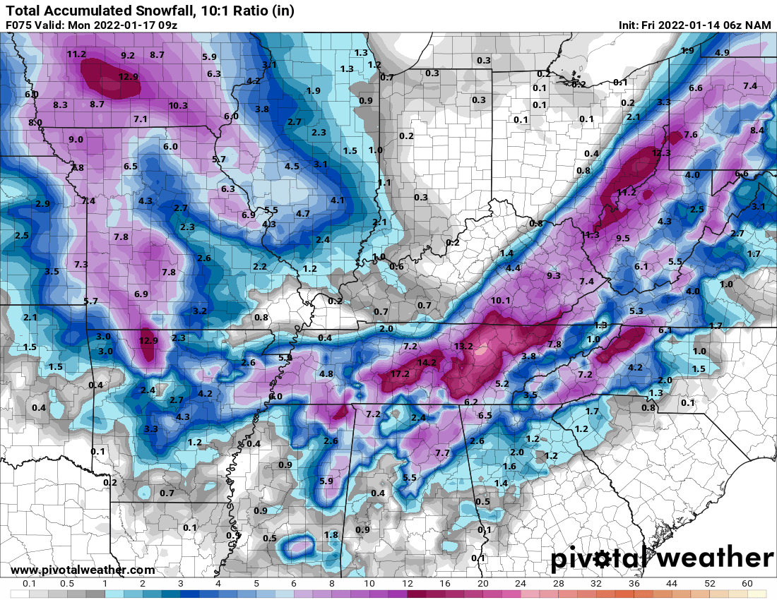
That map literally has me at 4" while just 15 miles away close to 8 lol
Winter 2021/2022 February Thread
in Tennessee Valley
Posted
Keep seeing reference to TIMS, what is that about if somebody doesn't mind explaining")