

Dsty2001
-
Posts
372 -
Joined
-
Last visited
Content Type
Profiles
Blogs
Forums
American Weather
Media Demo
Store
Gallery
Posts posted by Dsty2001
-
-
Ripping big fatties in greeneville rn
-
 4
4
-
-
1 minute ago, Silas Lang said:
Do any of you feel insane when it snows? Here I am, at 12:14 staring out the window, while everyone else is asleep.
Wife just yelled at me cause I keep going outside, took some extra sleepy time medication otherwise I'll be up all night watching radar and going outside lol
-
2
-
 9
9
-
-
Snow rates increasing here, slightly bigger flakes too
-
2
-
-
Small flakes falling here in Greeneville 32 degrees 20dp
-
2
-
-
3 minutes ago, Greyhound said:
Two questions related to roads:
1). When should it start sticking to roads in Knox County? Just all wet at the moment.
2). At what temp does the brine become ineffective?
.I'd imagine once the rates increase and the temperature drops a little more it'll start sticking on the roads as far as the brine goes I think it starts to become ineffective around 20° but I could be wrong
-
2
-
-
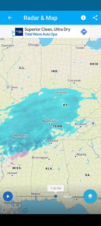
Also looks like Chattanooga is on the cusp of getting snow
-
2
-
-
1 minute ago, TellicoWx said:
3k Sim radar is a thing of beauty for central valley guys
Ohhh can you post it
-
2
-
-
32 degrees 20 dp in Greeneville, radar looking healthy!
-
3
-
-
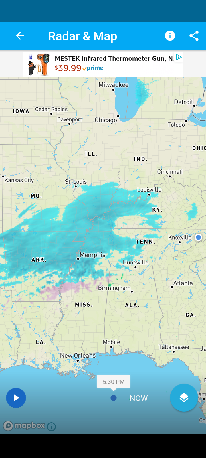
Looking beefy and healthy
-
5
-
-
Oh that isn't even the full run of the HRRR
-
1
-
-
HRRR isn't even matching up with current OBS
-
2
-
-
Wondering if the artic front is making a move, temp has dropped another 2 degrees here
-
2
-
-
5 minutes ago, Shocker0 said:
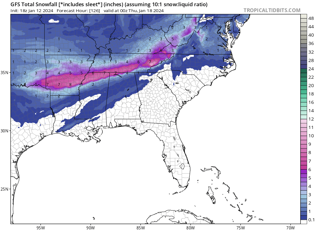
The "Rufus" model moves the heaviest snow well up into Kentucky
 at least Kuchera ratios.
I just don't see it

-
2
-
-
Looks like snow approaching Nashville, line goes all the way back to Little Rock. Precipitation looks pretty healthy on radar
-
1
-
 1
1
-
-
Temp has dropped 2 degrees here in last hour. We doing a OBS thread or keeping it all here?
-
1
-
-
Also MRX basically said what I've been thinking, with persistent snowfall and continuing chilling of the air, there shouldn't be any mechanics in play that would cause the temperatures to warm
-
4
-
-
000
FXUS64 KMRX 142035
AFDMRX
Area Forecast Discussion
National Weather Service Morristown TN
335 PM EST Sun Jan 14 2024
...New SHORT TERM, LONG TERM...
.SHORT TERM...
(This evening through Monday Night)
Issued at 319 PM EST Sun Jan 14 2024
Key Messages:
1. Increasing confidence in a heavy snowfall, especially Knoxville
and north, exact placement of highest amounts will depend on where
exactly snow band sets up.
2. Potential still exists for a mix of precipitation types along the
Georgia border, lending to moderate uncertainty on snowfall totals
in the southernmost counties.
3. Precipitation late Monday night into Tuesday morning might switch
to a light freezing drizzle as snow comes to an end.
Discussion:
Mostly sunny skies across eastern Tennessee currently will give way
to the clouds associated with the incoming snowstorm. Expecting snow
showers to begin moving into the valley tonight, sometime between
00z and 06z for first showers. HRRR is a little quicker than the
HREF mean, but siding on the side of caution given how timing has
gone thus far. It seems likely at this point that snow will stick
as temperatures will be falling below freezing as snow arrives.
Therefore last preparations for snow should be completed this
afternoon and early evening. With the guidance continuing the
trend today to move the start time of snow showers up, elected to
begin the warning at 00z tonight, the winter weather advisory in
North Carolina will remain 06z.
Snowfall has increased with this package, now expecting a broad
spectrum of 6 to 8 inches along and north of Interstate 40, with
another maximum along the Cumberland Plateau. This forecast is
slightly under the WPC guidance, and it seems likely that some
locations will accumulate higher amounts. Placement of these
localized higher snowfall amounts is uncertain depending on exact
placement of narrow bands of higher snowfall rates. The other
uncertainty in snow amounts continues to be along the border
counties with Georgia, where a brief mix of sleet seems probable
given the persistence in the high resolution guidance. For
temperatures tomorrow, stuck with persistence with the prior
shift. Some guidance, and the NBM, is warmer with the max
temperature, but it`s hard to reconcile that idea when no strong
advection is in place to power that warmth against the chilling
effect of ongoing snowfall.
Snow starts out tonight as generally scattered, and guidance has
indicated a lessening or pause before becoming more steady
stratiform snow with embedded bands during the daytime on Monday.
While the HREF doesn`t suggest any 1"/hr rates, steady snowfall will
lead to higher accumulations as Monday wears on. This translates
to road conditions steadily worsening, especially secondaries and
lesser frequented roads, as the day wears on. Monday night into
early Tuesday might feature light freezing drizzle on the backside
of the snow as moisture in the atmosphere lowers beneath the DGZ
and thus only supercooled water will fall. Ice accumulations with
this is expected to be a glaze at most.
&&
.LONG TERM...
(Tuesday through next Sunday)
Issued at 319 PM EST Sun Jan 14 2024
Key Messages:
1. Very cold temperatures in the wake of the snow that will tape off Tuesday
morning. Single digit/ near zero temperatures and subzero wind chills
possible Tuesday night into Wednesday morning.
2. Additional winter system possible Thursday night into Friday, but
details still uncertain. Ensembles are in not in the best agreement
with the system, but there is high confidence in cold weather behind
this system lasting through the weekend.
Discussion:
As drier air will begin to move in late Monday night into Tuesday
morning the main areas of precipitation will begin to exit the area
as the upper level energy shifts northeast. At the end of the
precipitation there is a possibility of some light freezing drizzle
or flurries before tapering off Tuesday morning. Any ice
accumulation should be minor with the snowfall being the main
impact. Very cold air then advects into the area Tuesday. High
temperatures Tuesday with the Arctic airmass high pressure will be
in the 20s with wind chill readings in the teens as winds will be
about 10 mph. With the high pressure area directly overhead Tuesday
night and early Wednesday winds decrease and temperatures will
plummet to single digits areawide. Wind chill temperatures Wednesday
night and early Thursday will be between zero and 10 below.
Wednesday night and Thursday the Arctic high pressure will shift
eastward and this allows winds to shift to the south and southwest
Wednesday afternoon and overnight. Temperatures warm about 10
degrees Wednesday night and another 10 degrees Thursday with most
locations in the 30s to around 40. However with anticipated snowfall
by Tuesday temperatures may stay below freezing in some areas.
The next weather change will be Thursday into Friday as a low
pressure area develops across the southern plains and with
increasing moisture will bring a fast moving front through the
forecast area Friday. The track of the low is expected to go south
of the region at this time. With the short period of southerly flow
and the uncertainty with warming based on entrenched cold air with
the Monday/Tuesday system expect precipitation amounts to not be
that high. If temperatures are in the mid 30s to around 40 at onset
of the precipitation Thursday afternoon like models are showing
there should be mixed precipitation with rain and snow. The mixed
precipitation should continue into the evening. Then the rain should
change to snow and become all snow by Friday. The amount of warming
and the moisture available will affect snowfall amounts. This is
still uncertain. The precipitation is moving out Friday night.
Behind the system Friday there is still a higher confidence of more
cold temperatures with Arctic High pressure building in Friday night
through Sunday. Lows again look to be in the single digits Saturday
and Sunday mornings. Highs once again in the 20s Saturday and then
warming into the 30s Sunday as the large surface high shifts east of
the Appalachians by late in the day.
-
MRX upped their totals, would post the map but it's blurry on my phone
-
1
-
-
Models tend to under model artic air, also it's been very rare in my experience for a system to start as snow for several hours then go to mix, granted it is East Tennessee and I've seen stranger things happen, I just have a hard time believing there will be any mixing issues for most of the area
-
1
-
-
11 minutes ago, tnweathernut said:
It looks like you guys/gals down around Knoxville have a GREAT shot with this one. Should be fairly widespread. This track has already been more fun than anything we got a look at last year.
The 18z gfs got tri cities pretty good
-
-
I keep noticing Greene and cocke counties keep getting the short end of the stick on these runs. Possible downsloping issues or what? Would certainly be strange for there to be more snow points south and west of us to get several inches and then a sharp cutoff but stranger things have happened
-
18 minutes ago, Greyhound said:
Where are you located? Eerily calm at my house in Knoxville. Stay safe!!
.Near Tusculum in Greeneville, getting pretty sketch lol
-
2
-
-
Not gonna lie, this wind has me concerned. Our little trailer is already shaking from the wind, might have to get us out if it continues to get worse
-
1
-
 1
1
-


January 15th-17th 2024 Arctic Blast/Snow Event
in Tennessee Valley
Posted
Interestingly, we've stayed all snow in northern Greeneville, however my sister which lives 10 miles south is mixing