

Dsty2001
-
Posts
372 -
Joined
-
Last visited
Content Type
Profiles
Blogs
Forums
American Weather
Media Demo
Store
Gallery
Posts posted by Dsty2001
-
-
From 12z the 23rd to 00z the 24th, the temp almost drops 40 degrees. Not saying it isn't possible as we've all seen drastic temp swings, but wow
-
It's....it's beautiful
-
 2
2
-
-
24 minutes ago, Carvers Gap said:
6z GFS overrunning event(can't find a better term for the multiple waves....though tech not a 100% overrunning event)
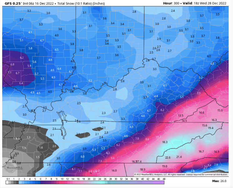
What's wild is thats at 10:1 ratios O.o
-
2
-
-
I'd imagine the ratios will be greater than 10:1 with the frigid 850's
-
5
-
-
Looks like Kingsport is about to get hammered
-
Attention then turns towards this afternoon and evening as
additional convection is expected to redevelop within the warm and
humid atmosphere. Temperatures are expected to climb into the 80`s
across the area, and dew points will peak in the upper 60`s. This
means there will be plenty of moisture for storms to feed off of in
the afternoon if convection can get started. Today is a bit
different than yesterday`s convection as there isn`t really a
significant source of synoptic level forcing to initiate storm
development, so determining location and timing of storms is a bit
more difficult. Water vapor imagery shows a bit of a moisture
boundary from southern Illinois down to northeast TN/southwest VA.
This could axis could be one of the forcing mechanisms for storm
initiation, especially south of this boundary...In addition to any
outflow boundaries left over from the overnight convection moving
out of eastern Kentucky. At this point the expect storms to
redevelop in the afternoon hours with the strongest solar heating
taking place. Forecast soundings and mesoanalysis continue to show
ample surface based CAPE of up to 4,000 J/kg in the most aggressive
models, and steep mid level lapse rates of over 7-8.5 C/km. Luckily
the deep layer shear looks fairly weak, and is mostly uni-
directional across our area, which will hopefully limit (but not
totally eliminate) tornadic development. An additional surge of
storms could move into the area after sunset from stronger storm
development over western Kentucky, but still some uncertainty if
this will move more into WV or VA.

The main threats with storms this afternoon and evening will be
Large hail possibly up the size of ping pong balls, and strong
straight line winds in excess of 70 mph. In addition storms training
over the same location could cause isolated flooding of low lying
and poor drainage areas, and an isolated tornado cannot be ruled out
at this point.

Storms will eventually come to an end after sunset and loss of solar
energy. Fog will be possible overnight as skies slowly clear out,
mainly in areas that receive rainfall from the afternoon storms.
-
 1
1
-
-
Hazardous Weather Outlook
National Weather Service Morristown TN
302 AM EDT Thu May 19 2022

NCZ060-061-TNZ012>018-035>047-067>074-081>087-098>102-VAZ001-002-
005-006-008-200715-
Cherokee-Clay-Scott TN-Campbell-Claiborne-Hancock-Hawkins-
Sullivan-Johnson-Morgan-Anderson-Union-Grainger-Hamblen-
Northwest Cocke-Cocke Smoky Mountains-Northwest Greene-
Southeast Greene-Washington TN-Unicoi-Northwest Carter-
Southeast Carter-Roane-Loudon-Knox-Jefferson-Northwest Blount-
Blount Smoky Mountains-North Sevier-Sevier Smoky Mountains-
Sequatchie-Bledsoe-Rhea-Meigs-McMinn-Northwest Monroe-
Southeast Monroe-Marion-Hamilton-Bradley-West Polk-East Polk-Lee-
Wise-Scott VA-Russell-Washington VA-
302 AM EDT Thu May 19 2022 /202 AM CDT Thu May 19 2022/

This Hazardous Weather Outlook is for portions of southwest North
Carolina...east Tennessee and southwest Virginia.

.DAY ONE...Today and Tonight

A round of showers and thunderstorms is expected this afternoon
into tonight. The primary threat will be strong straight line
winds and large hail. If multiple storms move over the same area
it could lead to isolated flooding of low lying areas.

.DAYS TWO THROUGH SEVEN...Friday through Wednesday

No hazardous weather is expected at this time.

.SPOTTER INFORMATION STATEMENT...

Spotter activation may be needed this afternoon and evening.
Please relay any information about severe weather to the NWS while
following local, state, and CDC guidelines.

$$
-
Not sure if anybody is interested but MRX has a virtual skywarn spotter training on their Facebook page. Here is the link but not sure if it'll work on here https://l.facebook.com/l.php?u=https%3A%2F%2Fstorymaps.arcgis.com%2Fcollections%2Fbd6cffba42de4339981758cecc110e36&h=AT2qeZpHqIolR1W7wmin-2uGVYYRDxGQi2O5chbiE_3kvVo4nxbtpyh0vw_oyyFpWeKCD4hx35VA2dajs92cBMLqWeW6S4S7_82eB7jAIz741jdc_kxBy1t-yjB5gFI4bA&s=1
-
1
-
2
-
-
Couple of images I snapped yesterday before the first storm rolled through


-
2
-
1
-
-
4 minutes ago, PowellVolz said:
Hard to tell without being there but regardless a cool video
.Yeah didn't realize my phone recorded at such poor quality, gonna have to check on that cause it's supposed to be 4k lol
-
2
-
-
Uploaded it to the tube, pretty sure it's scud but definitely one of the thicker scuds i've seen lol
-
2
-
-
This last one that came through was something else, pretty sure I recorded some rotation but gonna have to check the video out to be sure. Might have been scuds though
-
2 minutes ago, PowellVolz said:
Ohhh that should put it on track to hit me if it holds together!
.Ohh
-
1
-
-
Having a really intense storm roll through, started off with some hail then absolute down pour, pretty intense winds as well. Power flickering, won't be surprised if we lose power
-
Can't remember the last time a tornado watch dropped for the entire area
-
Tornado Watch
TORNADO WATCH OUTLINE UPDATE FOR WT 186
NWS STORM PREDICTION CENTER NORMAN OK
140 PM EDT FRI MAY 6 2022

TORNADO WATCH 186 IS IN EFFECT UNTIL 800 PM EDT FOR THE
 FOLLOWING LOCATIONS

TNC001-007-009-011-013-019-025-029-035-049-057-059-063-065-067-
073-089-091-093-105-107-121-123-129-137-139-143-145-151-155-163-
171-173-179-070000-
/O.NEW.KWNS.TO.A.0186.220506T1740Z-220507T0000Z/

TN
.    TENNESSEE COUNTIES INCLUDED ARE

ANDERSON             BLEDSOE             BLOUNT
BRADLEY              CAMPBELL            CARTER
CLAIBORNE            COCKE               CUMBERLAND
FENTRESS             GRAINGER            GREENE
HAMBLEN              HAMILTON            HANCOCK
HAWKINS              JEFFERSON           JOHNSON
KNOX                 LOUDON              MCMINN
MEIGS                MONROE              MORGAN
PICKETT              POLK                RHEA
ROANE                SCOTT               SEVIER
SULLIVAN             UNICOI              UNION
WASHINGTON
$$
-
I know not all severe weather is directly related to daytime heating, I experienced one of the worst storms during a day that had rain on top of rain, however my knowledge is super lacking in this area.
-
1
-
-
Been cloudy here all morning and now rain, wonder if that will limit the severe wx later today
-
1
-
-
Thor was very angry with that car
-
 2
2
-
-
I've seen some of the heaviest snow showers I've seen in a while today, looks like another one moving in
-
5
-
-
Had a burst of snow here :-o
-
3
-
-
Looks like more storms popping off to the west
-
Heavy rain and lightning, not a lot of wind but the light show was super impressive! With the way 2022 has went so far, stood outside for 10 minutes and decided not to press my luck lol
-
1
-
-
Temp got to 82 here, hoping to see some good lightning at least!
-
1
-
Historic Christmas Cold & maybe snow?! Dec 23rd-30th
in Tennessee Valley
Posted
I mean, it's still way to early to throw in the towel.