

Dsty2001
-
Posts
372 -
Joined
-
Last visited
Content Type
Profiles
Blogs
Forums
American Weather
Media Demo
Store
Gallery
Posts posted by Dsty2001
-
-
3 minutes ago, Holston_River_Rambler said:
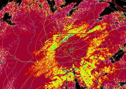
The last few frames of the correlation coefficient radar show it starting to accelerate, esp. from NW to SE. The ring around MRX radar site is getting smaller as the snow elevation drops.
Interesting! It seems our winds our from the NNW/NW right now and the temperature is dropping fast enough I can refresh the local weather station and see it going down lol
-
 2
2
-
-
If temps don't start crashing faster I will start to get concerned
-
-
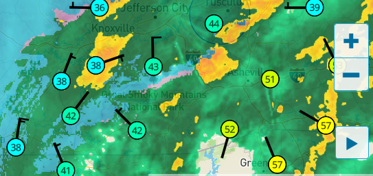
Anybody else noticing the rain/snow line starting to move from the south?
-
Looks like Harriman/Oak Ridge and Knoxville should be getting in the snow within the hour
-
-
Could be crazy but the cold air seems to be moving in faster than predicted IMO, changeover here in Greeneville wasn't supposed to occur till around 3-4am but judging by where the rain/snow line is, wouldn't be surprised if it gets here a hour or two sooner. Temp has dropped here another 5 degrees in just 30 minutes
-
1
-
-
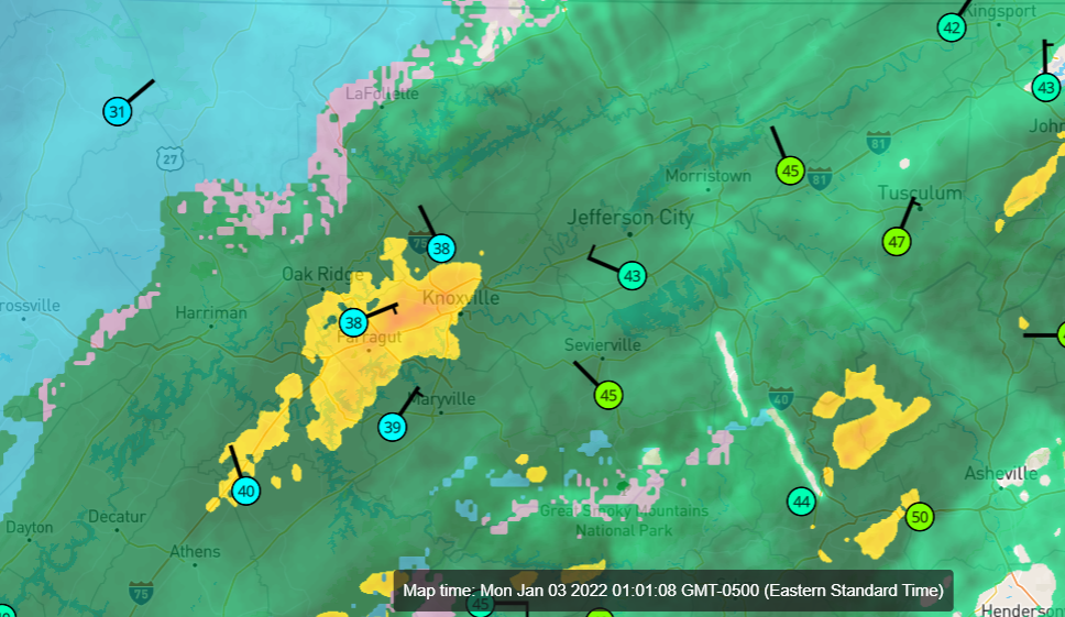
Judging by weather station temperature readings, there is a 10 degree separation between Greeneville TN and Rutledge, which is about a 50 mile difference. Temp here in Greeneville has dropped about 3 degrees in the last hour
-
1
-
-
Just now, Silas Lang said:
Just curious: does the cold rain actually help with the ground temps? Seems like it would, but I don't know.
From what I understand it can help cool it down faster
-
2
-
-
16 minutes ago, Carvers Gap said:
Have spent a lot of time out West. Warm ground temps rarely stop heavy snowfall from accumulating.
I know, I am just laughing at the posts on Facebook saying "Grounds too warm" for anything to stick. People apparently have short memories
-
3
-
-
So much for them warm ground temps lol
-
2
-
 1
1
-
-
Even in areas the rates aren't high it seems to be sticking, night time and low sun angle ftw?
-
3 minutes ago, Carvers Gap said:
Between three separate rain shadows, and downsloping winds...we know the drill in Kingsport. LOL. Not too mention we have easily the state's largest micro-heat island. Not so much a warm nose here as it is warm air that just won't scour out or that we make our own warm air. We also deal with downlsoping winds. Once that slp swings to our SE, the warm nose stops. What I saw with that 23z run of the HRRR was the slp was 1-2mb deeper over Upstate SC which has caused much more moisture to be on that model run. Last Christmas, took a while for the warm air to leave and for cold to flood-in from the Plateau. Our biggest advantage here is that we are have higher elevation than most cities....JC and Bristol are I think 100-200 feet higher than us. We will see...thermal profile will be threading the needle. Usually is.
tbh I think the snow just tries to avoid the stink from Kingston lol
-
1
-
-
So how are the short range models looking right now?
-
Am I wrong or does it appear the cool down is happening quicker than forecast in west TN? Looking at temp map looks like freezing line is quickly approaching Nashville
-
The bust potential is high, but I don't see MRX issuing WSW if they weren't confident. Timing will be key on how fast the cold air arrives, then of course how heavy the snow rates get. If they do reach 1-2" per hour as per the MRX discussion, I don't see why it couldn't accumulate quickly.
-
Gah, I hate to get excited but..
it's time to maybe get excited?
-
 1
1
-
-
So...is it time for us to get excited yet? lol
Not seen a thread with this good of potential not blow up or maybe people are just tired of being burned by the models
-
All good points, I have seen very heavy rates at the onset of a snow storm make short work of warm ground temps, there is a ton of variables. I was living in Maryland at one point and the temps had held steady in the 60s for a week or so, very heavy snowfall in the period of an hour and it was game over, even with marginal temps (think it was around 30)
-
I mean it would seem there is some pretty good model agreement that there will be some accumulating snow, MRX still seems shy to pull the trigger on any watches/advisories. This is within the next 24-36hr correct?
-
MRX will do as they always have, play it conservatively till the event is already underway. Can't say I blame them though, I've seen model support for heavy snows in the past only to end in cold rain.
-
2
-
-
Keep seeing people say no way it would stick since it's been in the 70s for weeks now. Little do they remember.. lol
-
1
-
-
I had just moved back to TN at the end of 2017 and was driving trucks over the road at the time. I seem to remember a surprise snow storm during that winter that dumped several inches but it quickly melted at least in White Pine.
-
1
-
-
I hope this winter is not a repeat of 2018-2019 rain rain and nothing but cold rain for months on end.
-
2
-

TIMS model verification, December 31, 2021 - January 3, 2022
in Tennessee Valley
Posted
Wasn't the official forecast for Knoxville to change over around 3am?