

Dsty2001
-
Posts
372 -
Joined
-
Last visited
Content Type
Profiles
Blogs
Forums
American Weather
Media Demo
Store
Gallery
Posts posted by Dsty2001
-
-
All snow Greeneville TN close to Mosheim, big fat flakes
-
 1
1
-
-
Sleet mixing in Greeneville, winds are howling. Surprised they didn't issue a wind advisory or extend the other one
-
2
-
-
Greeneville TN- Winds have picked up dramatically, temperatures are crashing,still rain but I think that will change soon
-
3
-
-
Friend in East Knoxville said it's ripping fat flakes there
-
2
-
-
Looking at the radar, very impressed with how the moisture is filling out on the back side
-
That's right you dirty storm, fill that back side up with moisture!
-
 2
2
-
-
Wonder what the models and MRX are seeing, I swear this system looks like it's moving way to fast or am I wrong?
-
1
-
-
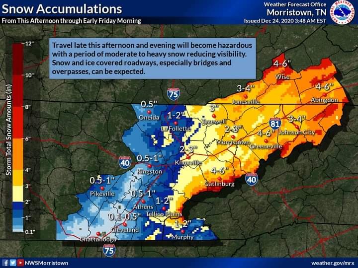
MRX basically bumped totals for the entire region
-
3
-
-
Are the winds we are getting tonight associated with tomorrows system? Just had a gust sound like it was making the roof tremble!
-
Hey man, with the way weather is in East Tennessee, flipping a quarter is about all we can do lol, but from the model trends I've been seeing I would agree with you
-
So are we thinking at this point this has a greater chance of busting low or busting high lol
-
Winds are getting a bit gusty here in Greeneville
-
3
-
-
Snowing at a pretty good rate here in Greeneville, everything is coated now
-
2
-
-
Already starting to get black ice in Greene co
-
1
-
-
Spoke with the wife in Greeneville, said snow is starting to stick on roads and temp has dropped below 32
-
2
-
-
Moderate snow Johnson City
-
1
-
-
At least based on radar the precip seems more healthy and abundant than what I thought was forecasted? Regardless, here in Johnson City nothing atm
-
Very tiny flakes in Greeneville, about to make my daily drive Johnson City
-
1
-
-
37 degrees 25 dp forecast low of 36

-
Wonder what's with that line of precipitation in E NC that seems to me pulling back
-
Feel like the forecast lows are going to bust high, already 38 here
-
Local weather station reporting 24 degree dewpoint Greeneville TN
-
2
-
-
Looks like they are expecting heavy cloud cover tonight keeping the temps from dropping even more, but right now in Johnson City clouds are clearing out so who knows
-
3 minutes ago, TellicoWx said:
Looking at all the soundings for central/southern valley and plateau, I think that was a good call. WWA, WSW, and WSW products are mainly influenced by travel (2"-3" of snow of the grass while pretty has little impact on the public). Most soundings are in the 34/35 range, couple degrees warmer than last weeks system..not ideal for accumulation on the roadways. Think they went a little too low for accums on grass and think the plateau will go to an advisory at some point.
From the way I read it they are only expecting .5-1" on grassy surfaces, road temps can also drop to support accumulating snow if there is a heavy enough band. Not sure how heavy this snow is supposed to be
Christmas Eve/Christmas 2020 Arctic Express Snow Obs.
in Tennessee Valley
Posted
Really surprised how quick it has started accumulating here, snow is coming down hard