

WidreMann
-
Posts
7,874 -
Joined
-
Last visited
Content Type
Profiles
Blogs
Forums
American Weather
Media Demo
Store
Gallery
Posts posted by WidreMann
-
-
2 minutes ago, CaryWx said:
Queen, Could you tell me the SREF snow mean for RDU
Half as much as 15z and temps warmer too. Looks like 00z NAM will follow suit with that.
-
 1
1
-
-
The biggest misspelling is '4-8"' over central NC.
-
 5
5
-
 5
5
-
-
Just now, Jonathan said:
Man, with a winter storm impending you CAN'T miss a few hours on this board. It's great though. So much info.
I need a quick recap! @Buddy1987 @Disc we still in for this baby in SW VA?
It's not un-probably maybe going to be unable to definitely not unsnow.
-
When do the 21z SREFs come out?
-
We had a penis posted. That's good.
-
1
-
2
-
-
10 minutes ago, wake4est said:
Weird I have no functional memory of that. Must have been really terrible for us.
It was snowing for several hours, but too warm to stick. But then in the late afternoon and early evening, it was sleeting and that did stick just enough to freak people out. We had half the normal folks at our contra dance and lost a bunch of money for a winter storm that wasn't worth SHIT.
-
1
-
-
1 minute ago, griteater said:
No, not the ULL...I'm talking on Sunday. 0 deg is roughly along NC/SC border early Sun, then bisects the state west to east midday, then it moves NW to western NC Sun aftn
That's warmer than the 12z, then, which keeps us around 0 until late afternoon/early evening.
What are the snow totals for central NC looking like before the changeover?
-
1 minute ago, griteater said:
Just mean that it doesn't jerk the 0 deg line NW right during the "1st half of the heaviest precip", but rather, during the 2nd half of the heaviest precip that rolls thru
I mean what are the time frames for first half and second half. Are you talking about the ULL moving through Monday, or are you talking about Sunday afternoon?
-
4 minutes ago, olafminesaw said:
Bullish as always

Yeah, that might have been reasonable two days ago.
-
2
-
-
29 minutes ago, wake4est said:
Found this on my laptop from one year ago today. Did anything become of this? I cannot remember what we were chasing.
The December 8th storm, probably, which ended up being snow in the NW quadrant of NC, rain mixed with sleet and some snow over the Triangle and otherwise just a cold mess.
-
Can we just ban the clown maps? They are worse than useless.
-
2
-
1
-
-
1 hour ago, Brick Tamland said:
Great, the other mod comes in and deletes my comment that was on topic just as much as others. Guess some things never change.
Your comments are never on topic.
-
1
-
-
12 minutes ago, griteater said:
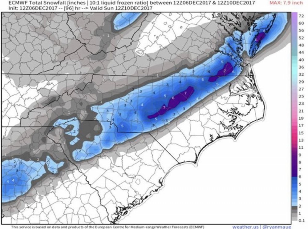
18z Euro compared to 12z was similar overall with temperatures. It brings the 850 0 deg back to just east of the NC Mtns during, say, the 2nd half of the heavy precip portion of the storm. It was wetter this run thru NC where there is a large area of at least 2 inches liquid. Here are the last 4 runs of total precip for the storm to Monday morning (12z Mon)

What is the second half of the storm?
-
12 minutes ago, isohume said:
The EC was used and weighted along with some GFS/CMC fields. The NAM profiles were not incorporated as it was deemed too warm at h85 and was an outlier, but will be watched for further trends. In my personal experience the NAM normally does quite well with the warm nose in this area.
So does that mean you were outvoted?
-
2
-
-
Snow line further east in NC with slightly cooler temps. Strong NEly flow at 925, easterly at 950 and weakly southerly at 700. Below freezing throughout the column at RDU.
-
2
-
-
It looks a little stronger at 500 with the southern stream wave, and there's a s/w diving into it from the north, more pronounced than before. But we still have good confluence over NE.
-
If anything, it's a little slower with both streams, which means it'll start to match up with the Euro and make RAH happy. Also means confluence will stick around longer in NE.
-
591 a little bigger over Cuba.
-
ICON apparently uses icosohedral representation of space. Why, I don't know.
GFS is starting to roll in. Getting ready to have your hopes and dreams dashed against a rock.
-
3
-
4
-
 1
1
-
1
-
-
1 minute ago, SteveVa said:
Speaking of sampling, didn't @dtk at one point debunk the theory that models are less accurate if the shortwave is over an area with almost no in-situ observations?
I hope so. Can you find it?
-
Just now, Wow said:
NAM builds in a 1040mb banana high over the OH valley to the NE. You can't ask for anything better. It's like an old 384hr GFS fantasy storm coming true.
Instead it's an 84 hour NAM fantasy storm.
-
8
-
1
-
-
Dry slot is not on the north or northeast side of the storm, so nobody.
-
1
-
1
-
-
I consider any December event to be bonus, so I don't care about warm ground.
-
1
-
 1
1
-
-
Boy does it drop temps and DPs at the leading edge. Sounding for Durham has wet-bulb temps in the mid-upper 20s all the way up, and SFC down to 31. Precip looks like it's still evaporating, so there's more cooling to go.
-
3
-

December 8-10, 2018 Winter Storm
in Southeastern States
Posted
Big blow up of snow accums just north of the Triangle. We're over to ZR by late morning.