

WidreMann
-
Posts
7,874 -
Joined
-
Last visited
Content Type
Profiles
Blogs
Forums
American Weather
Media Demo
Store
Gallery
Posts posted by WidreMann
-
-
Just now, yoda said:
Uh no, GGEM stalls and then heads inland just SW of OBX
Must have gotten old images.
-
Meanwhile GGEM stalls and then goes out to sea, albeit near the coast.
-
I'm amazed at how small the western part of the precip shield is. GFS doesn't give any rain for central and western coastal plain, even though winds pick up. Strange.
-
 1
1
-
-
5 minutes ago, SENC said:
@Downeastnc remember this?
Which storm was that?
-
West trend continues through 27. May not be enough to avoid the loop.
-
4 minutes ago, olafminesaw said:
To kick off the 0z models, the ICON takes a pretty decent shift to the left with a landfall around Cape Lookout.
The great convergence has begun.
-
2 minutes ago, downeastnc said:
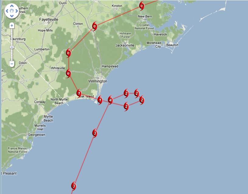
Its based on Euro data from last run, the official NHC track is right of this a good bit the center would move on a line from Jacksonville to Goldsboro to RDU

I also have no idea how good the Euro's wind gust maps are. The sustained winds map is in the 30-50 mph range for comparison.
-
weather.us shows basically the same numbers, even higher as we get into Friday afternoon. I really hope it heads further south, or keeps inching eastward and we can stay on the western side of things.
-
3
-
-
6 minutes ago, Brick Tamland said:
I know, but they were both labeled 2 pm Friday. The last update had it as a hurricane then, and this one is back to a tropical storm. I guess they are back to thinking it will downgrade faster once it comes inland.
If the storm is moving faster or slower, that will affect its status as of 2 PM on Friday.
-
10 minutes ago, Blue_Ridge_Escarpment said:
I didn’t see the Euro shifting way east. Especially not it’s ensembles.
But they did: https://weather.us/cyclone-tracks/euro/800-w-320-n/2018091012-240-florence.html. Compare with 00z.
-
I feel like I deserve a roasting. I mean, the HRRR temps were worrying and we did stay above freezing for most of the event, but we still got a ton of snow.
-
2 minutes ago, No snow for you said:
So we are adding Raleigh and mooresville to places with more snow than Greenville after today. At least I don’t live in simpsonville
Except north central Wake, where it is only flurrying. They are having some really bad luck.
-
10 minutes ago, PirateWx said:
This has been absolutely agonizing to watch for mby, coastal low eating all precip as it hits the western boundary of the county just for it to return on the eastern side...nothing in b/t
Y'all normally get the coastals while RDU gets skipped.
-
I'm still baffled by the warming. In what universe does moderate or more than moderate snow with a north wind and a completely cold column result in temps warming at the surface? I swear, every storm there's a new meteorological phenomenon that comes in to screw us.
-
Called it. Ofc, it's snowing now, but it's at 33 and now the other models show temps warming through the event. Not sure how, but I guess that's the way things go.
-
7 minutes ago, snowinnc said:
You’re in Chapel Hill, correct? If so then I’m not sure why you’re complaining. Those of us in Wake County have legitimate concerns but you are pretty much in the sweet spot.
South Durham, which performs poorly with nearly every storm and I don't know why. Perhaps Jordan Lake. Perhaps gentrification.
-
Models keep shifting NW and delaying. Temps are too warm. This and that, the usual. I'm guessing we'll see an inch around RDU. I guess if we have enough 1" storms we can reach an average winter again.
-
Just now, SnowNiner said:
Every model I've seen has Raleigh and eastern/central NC in the sweet spot. Hey but if you want to give me more snow, I'll take it!
I am concerned with the continued forecast for rain/snow at the onset by my NWS.
Have you seen the HRRR and the 18z GFS? Both keep us above freezing, albeit slightly, through most of the event. RGEM I think is also like that. HRRR actually raises temperatures after precip starts. Hard to believe, but entirely in line with the kind of thing that would happen here.
-
I know that the RAP isn't actually the most accurate model, but with it showing the continued trend of warming at the surface and precip further west, it's starting to indicate to me that this is going to be another western piedmont special. It is curious, though, that we can have falling snow, a decent northerly wind and still have BL temps warm. But hey, I've seen weirder things.
Moral of the story: don't bank on snow in the Triangle unless the models show you in the sweet spot ON THE DAY OF THE EVENT. Even 24 hours before is not enough.
-
1
-
-
Surface temps rear their ugly head and now we have a last minute NW trend. My cynical call is 1.5" tops for S Durham and most of Wake. If it trends anymore, cold rain isn't out of the question.
-
 2
2
-
-
EPO will kill us, guaranteed. It's all that's been saving us.
-
I'm wary of snows with frontal systems. Just in watching rain events with fronts, we've so frequently underperformed. Usually we don't care, so it goes unnoticed. My suspicion is that we'll have spotty snow showers that will be more solid towards VA. Some places around here will get a dusting or maybe some real accumulation, but unlikely.
-
What's been really weird to see is the radically neutral NAO. Usually there's a lot more variability. I suppose that speaks to the lack of storm systems of note coming through eastern North America.
-
The snow hole is honestly amazing. I don't think I've ever seen it be that bad before.

Hurricane Florence
in Southeastern States
Posted
I bet they'll slow it down at 5 AM. They probably want to see the 00z suite before going all-in on the stall-and-meander solution.