Gino27
-
Posts
556 -
Joined
-
Last visited
Content Type
Profiles
Blogs
Forums
American Weather
Media Demo
Store
Gallery
Everything posted by Gino27
-
Euro did some weird crap. Came west with precip but ULL was east. Tomorrow will be very interesting
-
There has been a subtle trend on all models to make the trough negative sooner which could help bring everything west. Time is on our side if that evolution wants to take place with new data.
-
Lol at the NAM. If only…
-
I’m definitely not a fan of recent trends. The ridge out west is much stronger and models are just starting to pick it up, which is forcing things east.
-
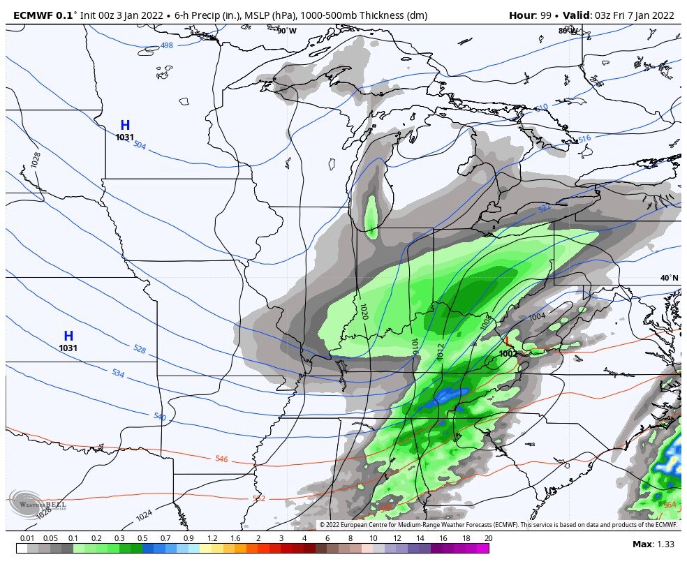
Euro crushes US-23 corridor
-
Even though there's really no blocking to keep this thing from going more west, I think a near miss to the east is most likely. I expected the GFS to start heading SE eventually.
-
Not the new run. It's windshield wiper time!
-
Euro took a huge step towards GFS/CMC camp. I wonder what the western limit of this trend could be. 100 hours is an eternity with something this complex.
-
Wow
-
GFS just spit out the wackiest run of all time, but nonetheless NW trend continues.
-
Sure did. Something to watch going forward, but our anti-snow force field will be in full effect!
-
No doubt. If we learned anything from the last storm, we're not in or out of anything until the snow is on the ground. This, however, is what I like to see for snow around here.
-
GFS brings a miss to the SW. I think a SW miss is the only one we haven't had yet this year.
-
GFS and NAM show a tiny clipper early next week. Euro had it yesterday. Now that I’ve put it on the internet it’ll disappear!
-
I usually call it quits around the last week of February. I get awfully tired of the short days and lack of foliage.
-
Unless we find a way to scrape together 1.3" of snow in the next 7 days. Columbus will be on pace for the least amount of snow since 1940, barring only the 2006-2007 season in which we would need 4" by the 21st to surpass. Even the infamous 2011-2012 winter had 4.5" of snow accumulated by January 14th.
-
I've been seeing some NW ticks on the models. We just going to get enough curl on vort before the coast robs our energy, and the confluence is still going to squash everything. It is a shame, but long range doesn't look as bleak as it once did.
-
Confluence is in the absolute worst possible spot and much stronger on the 18z GFS. The look that the NAM gave is pretty much our only hope.
-
We're always hosed by NW trend, or the lack there of. It must just be our climo/geography.
-
We made it under 100 hours before slipping away this time! That's major progress!
-
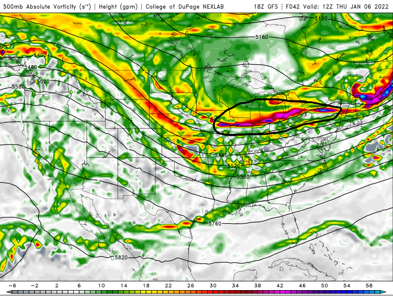
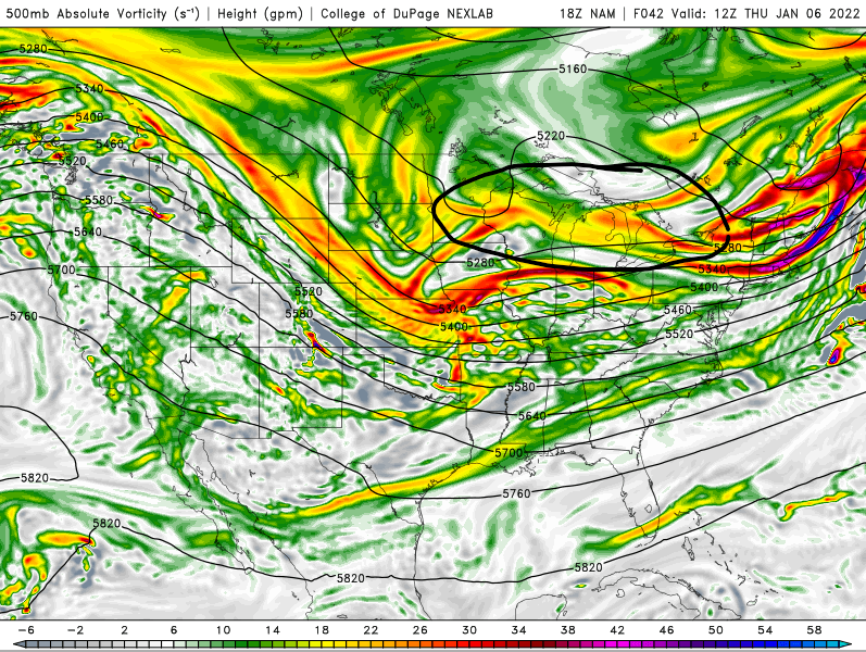
For what it's worth, the storm that's pounding the Mid-Atlantic followed a pretty significant NW trend within 90 hours. But the setups just aren't comparable. Within the last 24 hours the GEM and UKMET have gone back and forth a lot and the Euro has been most consistent, so we at least have that.
-
GFS has been shifting towards the Euro in terms of handing the first wave, but I fear the Euro has been over-amplifying the second wave. CMC might've just taken a huge step towards what the GFS has been showing.
-
GFS keeps ticking slightly better on 500 vort, but looks the same if not worse overall.
-
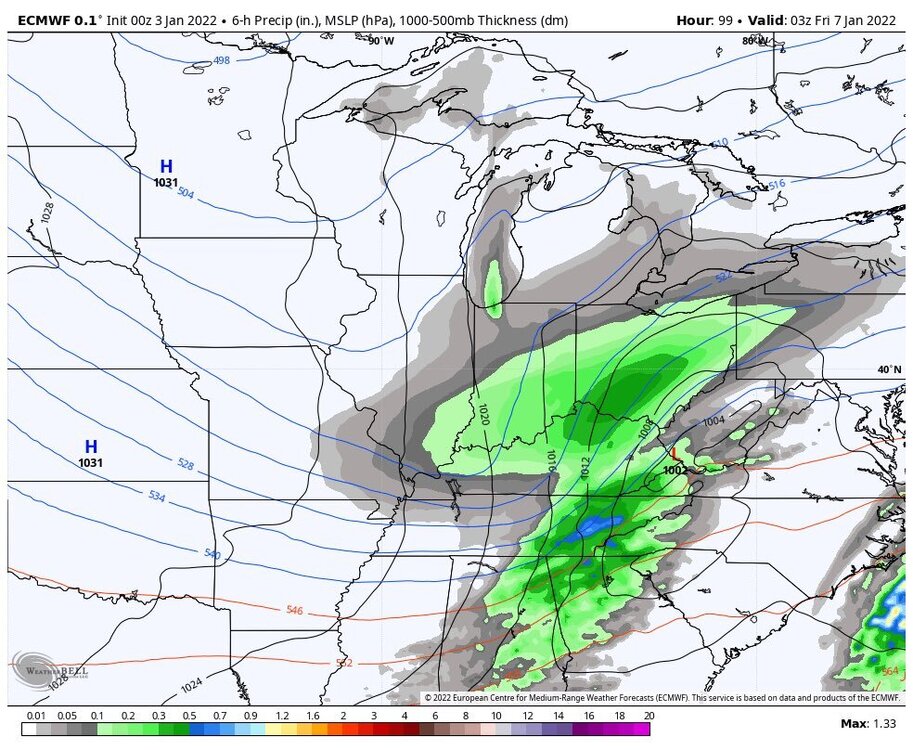
Euro coming in with more of the same. Getting closer folks.
-
GFS took a step towards the better solutions for us. Still need a lot of work, and everything else has to hold serve