Gino27
-
Posts
556 -
Joined
-
Last visited
Content Type
Profiles
Blogs
Forums
American Weather
Media Demo
Store
Gallery
Everything posted by Gino27
-
ILN launched a special balloon about 30 mins ago which will tell a lot of the story. Until we see that it’s gonna pound sleet for a while. Radar looks juicy.
-
I don’t think we changeover until around 6pm.
-
maybe shoulda stuck with my first map lol. Anyways still a long way to go There’s still snow down to texas

-
I can see snow on security cams back home in plain city. That’s surely an early “changeover” even though it’ll go to sleet later on
-
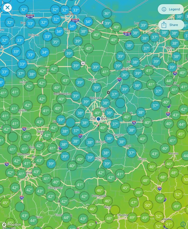
Osu campus at 33.7 House in plain city is at 29.7. This cold is coming in quickly.
-
I've got a big Calc 2 exam tomorrow so sleep will be limited + the distraction of watching the storm. Come on OSU cancel everything!!
-
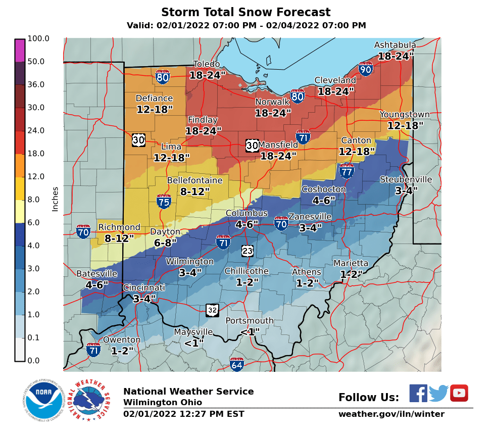
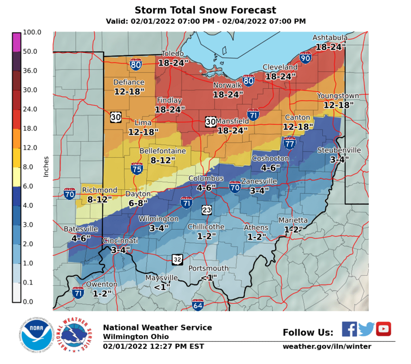
Me neither. I'm sticking with 2-4" for Columbus area with maybe an inch of sleet if it really pounds
-
Temps are definitely running a bit cool in spots. The main front is still where expected, though.
-
Here's the maps I just posted on my twitter page. I'm riding with the warmer guidance for now. The system seems a little bit moisture starved as of now, and I think that will reduce dynamic cooling.


-
but damn it doesn’t get much better than this

-
Wouldn’t be shocked if Wilmington goes with a winter weather advisory for parts of central Ohio. We don’t meet the 6” in 12 or 8” in 24 hour criteria for snow, or the criteria for ice storm warning based on their forecast
-
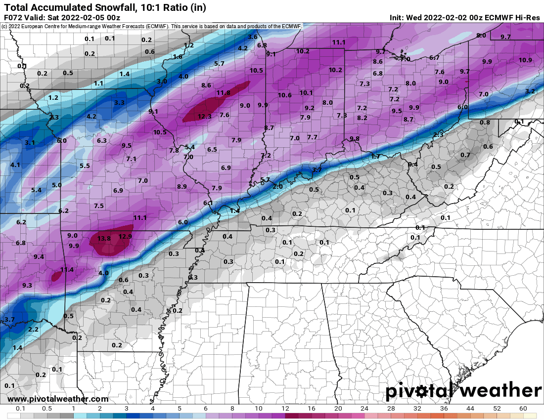
3k nam is much better and seems to reflect the 500 changes much better too.
-
NAM sucks. Tough scene
-
Glitch in the matrix
-
Euro does tend to have a dry bias, but it is concerning to see such a short period of precip compared to other models.
-
Euro with another step to GFS. I'm really interested to see where this ends up in 24-48 hours. Intriguing for sure!
-
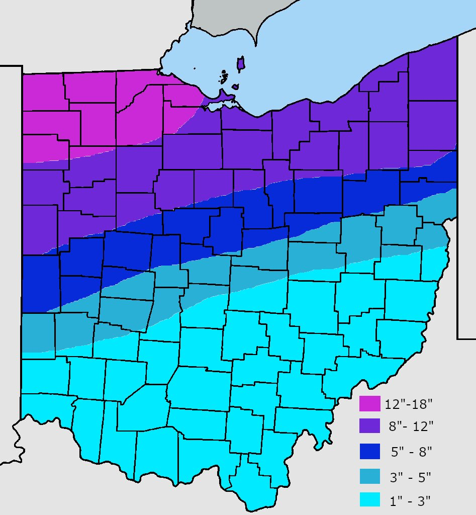
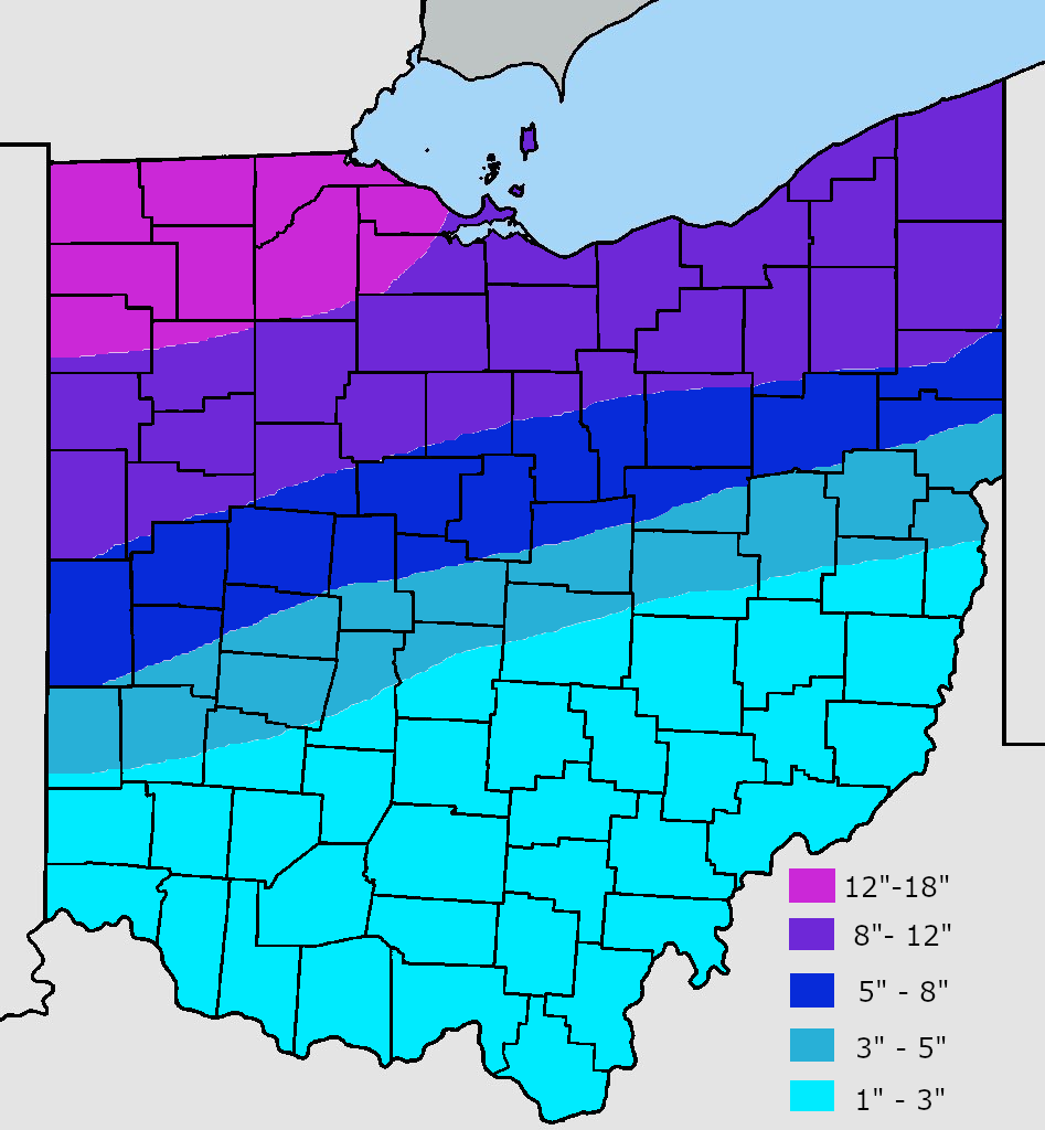
We love the line. Best thing is that I think the icing risk is reduced for Columbus area. Maybe I’ll pile up 3” of sleet like last year here on OSU campus. The snow shenanigans are always worth it!
-
Most of Columbus is still shafted. Gonna need another day of model shifts like we had yesterday
-
I'm thinking we all want it SE for better ratios and the inevitable NW trend/warm tongue of death... even though this setup doesn't really warrant that I guess.
-
GFS is best case scenario in my eyes. Maybe it can keep going SE??
-
Models are still all coming SE initially, but the second wave seems to get amped and we end up with just as much mixing.
-
With the windshield wiper effect I'd have liked to see a much bigger nudge south. This makes me fear that 18z is the furthest south it can possibly go, and it'll correct north with time.
-
Nam is a mega sleet fest for us. Still nudged south though.
-
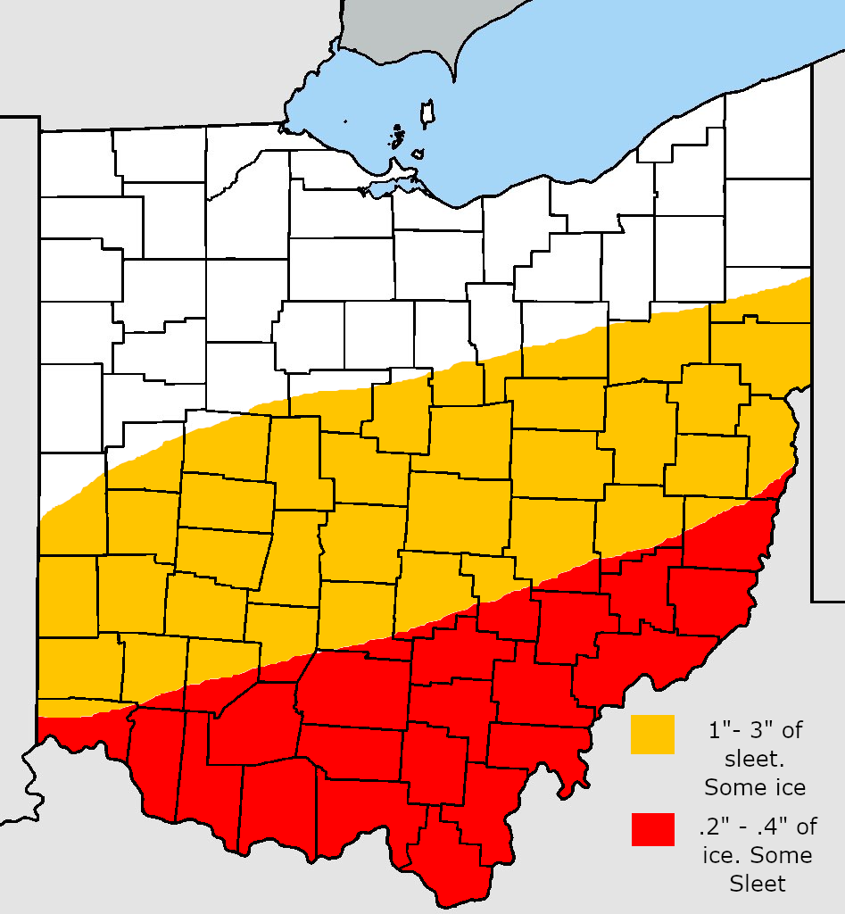
I don't love the wording, though. Scary stuff. IMPACTS...Power outages and tree damage are likely due to the ice. Travel could be nearly impossible. The hazardous conditions could impact the morning or evening commute. I'm also a little surprised they aren't mentioning the sleet either.
-
ILN dropped some watches. For areas NW of Columbus metro: OHZ026-034-035-042>045-010415- /O.NEW.KILN.WS.A.0002.220202T1500Z-220204T1200Z/ Hardin-Mercer-Auglaize-Darke-Shelby-Logan-Union OH- Including the cities of Kenton, Ada, Celina, Coldwater, Wapakoneta, St. Marys, Greenville, Sidney, Bellefontaine, and Marysville 304 PM EST Mon Jan 31 2022 ...WINTER STORM WATCH IN EFFECT FROM WEDNESDAY MORNING THROUGH FRIDAY MORNING... * WHAT...Heavy mixed precipitation possible. Total snow accumulations of 6 to 11 inches and ice accumulations of one tenth to four tenths of an inch possible. * WHERE...Portions of Central and West Central Ohio. * WHEN...From Wednesday morning through Friday morning. * IMPACTS...Power outages and tree damage are likely due to the ice. Travel could be nearly impossible. The hazardous conditions could impact the morning or evening commute. * ADDITIONAL DETAILS...Wind chills will likely fall below zero degrees Friday and Friday night. And for Columbus metro: ...WINTER STORM WATCH IN EFFECT FROM WEDNESDAY AFTERNOON THROUGH FRIDAY MORNING... * WHAT...Heavy mixed precipitation possible. Total snow accumulations of 4 to 6 inches and ice accumulations of two tenths to four tenths of an inch possible. * WHERE...Portions of East Central and Southeast Indiana and Central and West Central Ohio. * WHEN...From Wednesday afternoon through Friday morning. * IMPACTS...Power outages and tree damage are likely due to the ice. Travel could be nearly impossible. The hazardous conditions could impact the morning or evening commute. * ADDITIONAL DETAILS...Wind chills will likely fall to near or below zero degrees Friday night.