Gino27
-
Posts
556 -
Joined
-
Last visited
Content Type
Profiles
Blogs
Forums
American Weather
Media Demo
Store
Gallery
Everything posted by Gino27
-
Nice
-
Not sure pattern supports it, but the latest trends with PNA and NAO could bring it more west like that.
-
Even with the worst solutions being CMC and ICON, we would still pull a white Christmas out of those. Really hoping we're still tracking this thing under 100 hours.
-
Big difference with the GFS and Euro is that the Euro has a coastal low which doesn't let the wave dig from the NW, therefore we are warm and rainy
-
I'm not giving that threat any attention for a few days
-
There's something of a signal around the 19-20th, but suppression just rips it apart.
-
Still haven't had anything near Columbus, but I think that changes this week.
-
Warm nose. Sleet-fest. 33 and rain. Bring it
-
I-71 flexing

-
Columbus has been pretty lucky with avoiding ice storms recently. Not sure our luck will keep going this week.
-
Was just talking to some people about this very thing. Maybe we squeeze one more storm in during this upcoming cold and dry pattern, plus a clipper or two, but overall things look to heading towards winter wrapping up. I’m sure we’ll see some nuisance snows in spring but I’ve been killing for a decent stretch of severe weather.
-
All the heavy returns are sleet. Looks like the lighter bands are actually producing the accumulating snow
-
Looks like another dry slot after this bout of sleet. That could further warm us up. Ugh
-
Back to snow for now. Looks like pockets of sleet around for a bit longer Edit: back to sleet. I need to distract myself for the next hour lol
-
This sleet is rather frustrating. Just keeps building back in
-
I'm not concerned about this bout of sleet. We changed over to snow way earlier than I expected, and i think most of Columbus is back to snow by 7:30-8:00. Also radar returns to our SW look awesome and we should be ripping now once we change back.
-
Line stalled and coming NW if anything…
-
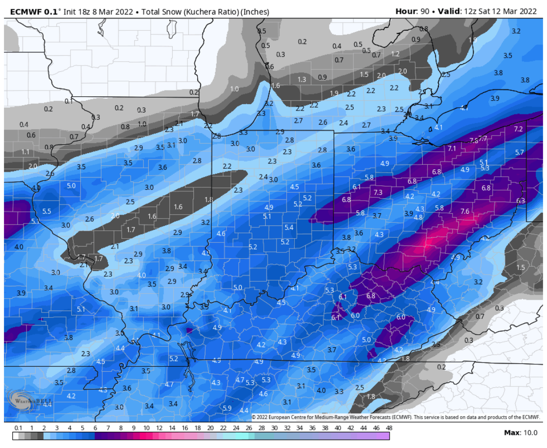
Wow this is a very intense snowband and we could stay under it for several hours too. Not to mention lots of moisture coming up in SW Indiana too.
-
Most of Columbus is about to get crushed. Very heavy snow to the NW
-
r/s line is screaming east. Gonna need it to keep up momentum. 850 temp advection is still really strong and there will likely be a warm push from the south to with the last surge in moisture. Really hoping we change over to dynamically cool the column before all this happens.
-
No doubt. Fgen is absolutely cranking too
-
Would love to see the line pick up the pace and change us over in Columbus near sunset. I think we would still get a major snow out of this if we do.
-
R/s has been moving SE. I think it’ll hit a wall around US/42 for a while though but dynamic cooling should help out
-
Yep looks like some flakes near plain city
-
Snow/Sleet line is "backbuilding" on itself near dayton. Dynamic cooling is definitely helping, but we are still an hour or two away from our main warm push.