

Dalfy
-
Posts
514 -
Joined
-
Last visited
Content Type
Profiles
Blogs
Forums
American Weather
Media Demo
Store
Gallery
Everything posted by Dalfy
-
Nice! Looking like they'll upgrade us soon. EDIT: just happened: 6-9'' call STL metro
-
Glass from STL CWA, stuck to his guns in the 1pm update. It's also interesting they're the only CWA to not expand wind chill warnings south of the central portion of their forecast area. Other potential areas for concern with this forecast are exactly what the SLRs will be and whether we might be a tad low on snowfall for Monday. Given the very cold air mass, snow ratios should be high with dendrites dominating. Present thinking is that storm total snowfall amounts will range from 2-3 inches in far northeast MO and west central IL to 4-6 inches encompassing the remainder of the CWA. These totals agree well with GEFS exceedance guidance using a max SLR, and are in the 50-90th percentile of the NBM. Noteworthy is our operational NBM data looked a bit light on QPF for Monday. The winter weather advisory looks on target for this event considering the aforementioned expectations and has been expanded to include the remainder of the northern CWA.
-
STL's criteria is >=6 inches I believe. They haven't updated their AFD or forecast since this morning at 6, before the NW shift; they were calling 4-6'' which is under their warning criteria. "Other potential areas for concern with this forecast are exactly what the SLRs will be and whether we might be a tad low on snowfall for Monday. Given the very cold air mass, snow ratios should be high with dendrites dominating. Present thinking is that storm total snowfall amounts will range from 2-3 inches in far northeast MO and west central IL to 4-6 inches encompassing the remainder of the CWA. These totals agree well with GEFS exceedance guidance using a max SLR, and are in the 50-90th percentile of the NBM. Noteworthy is our operational NBM data looked a bit light on QPF for Monday. The winter weather advisory looks on target for this event considering the aforementioned expectations and has been expanded to include the remainder of the northern CWA."
-
Our AFD from yesterday: "As the main surface system passes south and east of the CWA overnight Sunday into Monday, the probability of accumulating snow ramps up mainly along and south of the I-70 corridor. Upper-level divergence from the trough and mid-level frontogenesis will couple with cold air to produce efficient snow-to-liquid ratios. By the time this system departs the CWA Monday afternoon and evening, snowfall will range from 2-5 inches along and south of the I-70 corridor. I continue to have confidence in these totals, as blended and ensemble guidance continue to focus the greatest snow potential and amounts along this corridor." Learning moment: never have significant confidence in models >48 hours out, lol.
-
STL's AFD. They feel confident w/ call for 2-5'' along and south of I70 within their CWA
-
STL's AFD
-
LOL, I'm glad you appreciate the humor.
-
-
I feel for all those tech migrants from California.
-
Nothing in STL.
-
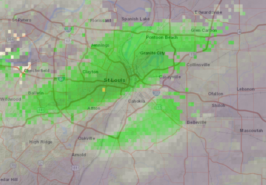
Perfectly situated band over downtown STL. ~28-30dbz. I don't have a way to really gauge the accumulation here but its accumulating quickly. Perhaps nearing 0.8 or so inches? Lovely outside. Temp is 17
-
Very light flurries in downtown STL @ a balmy 23. Most of the precip has been to the north and south of me
-
Downtown STL is around .6ish I think. Not too much but made for a nice walk.
-
Record setting cold run on the 18z gfs
-
Jan 31st - 33rd Storm Obs and Disco like it's 1979
Dalfy replied to Bob Chill's topic in Mid Atlantic
Yea I'm not going to miss that at all, haha. It was like a never ending set of really convincing mirages. Not to mention all the lost sleep and work productivity, checking models every 6 hours. God, it was torture but so addicting. Oh yes, that's something I'm looking forward to experience. Really hoping we can squeeze one event like that before winter ends. -
Jan 31st - 33rd Storm Obs and Disco like it's 1979
Dalfy replied to Bob Chill's topic in Mid Atlantic
Wish I could be there for this.. I've temporarily relocated to MO, aka no more noreasters for me . Anyway, here's an update from the wunderground station near my old house in Olney: light snow, 27. -
Measured a little over 11'' in Olney. We really hit the jackpot here with this one, and I for one am thoroughly satisfied! I'm hoping this is a good indicator for things to come with the pattern shift on the 20th. I am a bit winded from the obs and storm-tracking -- I forgot how much energy and attention storm monitoring involves.
-
Can definitely confirm that. Went on a 30 min walk and it's just pouring snow, my hair stood no match.. must've had like a half inch accumulate on it by the time I got back home. I measured something like 8.5 inches on the grass near a local road so I think we had somewhere between 9 or 9.5'' so far correcting for compaction.
-
It's just off Outerbanks. https://www.spc.noaa.gov/exper/mesoanalysis/new/viewsector.php?sector=19#
-
It's really coming down hard
-
It started intensifying here [Olney] just as I finished shoveling, lol. Oh well, it'll be easier the second time round
-
Jebman, sorry for butting in. You and your posts literally symbolize the epitome of the enthusiasm that drives half the board to be weather enthusiasts. I honestly don't think this forum [and the predecessor] would be the same without your posts. Don't trivialize them!
-
It's like communion during mass, it's a deep-rooted tradition -named after Jebman- of walking through a snowstorm for the sole reason of admiring the scenery. Now that you know, you should go take one and snap some photos
-
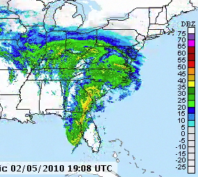
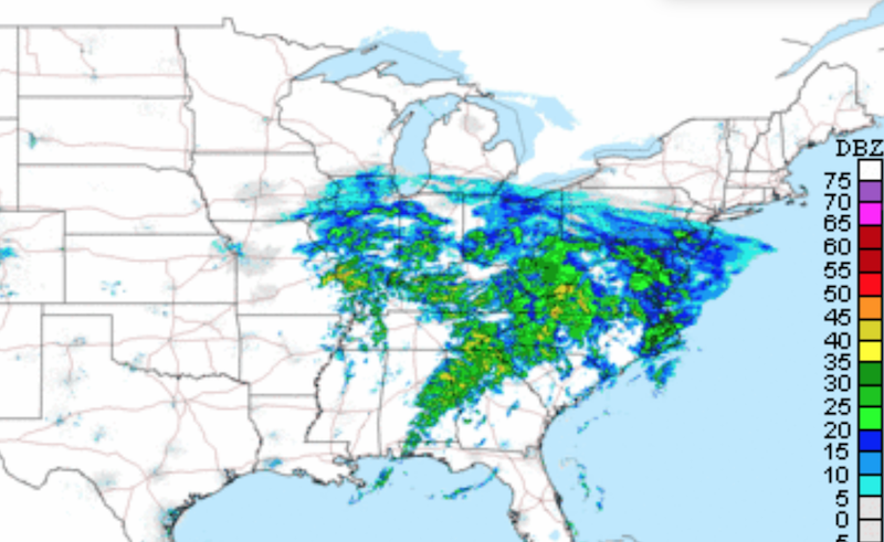
Very much an uncanny resemblance [first is current radar; second is feb 2010]. The precip shield on the east side is oriented differently and not as intense but the same general shape and breadth. Pretty cool if you ask me
-
Roads are covered in rockville and probably a little over half inch on non-asphalt surfaces. I'm really impressed with how fast the snow came in, not much Virga despite the low dew points earlier today


