

NorthHillsWx
-
Posts
6,913 -
Joined
-
Last visited
Content Type
Profiles
Blogs
Forums
American Weather
Media Demo
Store
Gallery
Everything posted by NorthHillsWx
-
https://x.com/markhuneycutt4/status/1839632280165253555?s=46&t=NyKvXvI1o-sJQb-68mmo4g
-
Exceptional, catastrophic, unimaginable flooding ongoing in the western Carolina’s. Unreal
-
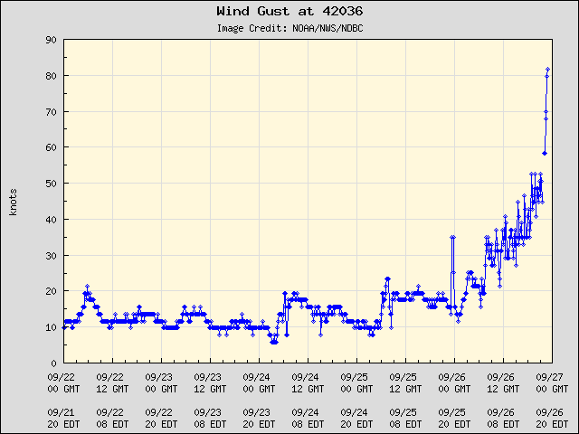
Downtown Greenville sustained 41 gusting 60 Anderson 67 mph gust
-
Gusts to 55 in Charlotte right now and over 60 in Clemson. That’s a large area of lights out
-
Clemson sustained at 33 kts gusting to 55 kts
-
Since I posted this 21 minutes ago. Outages have almost doubled. 350k in the dark and skyrocketing
-
Escalating quickly
-
First of likely many flash flood emergencies up. Avery county
-
Duke outages are skyrocketing. Up over 100k in last hour. Currently 176k and that’s likely to double
-
82 mph gust in Augusta. Station went down immediately after. Unbelievable EDIT: back online and still gusting over hurricane force. That city is going to be unrecognizable in daylight. Lots of pine trees
-
https://x.com/nwscolumbia/status/1839601665202409626?s=46&t=NyKvXvI1o-sJQb-68mmo4g
-
Augusta is currently sustained 51 gusting to 73. That is one of the more impressive sustained inland wind readings I’ve ever seen from a non elevated site thus far from a tropical systems landfall. There is no doubt devastating tree damage occurring. The core of the hurricane force gusts looks aimed for Greenville to me
-
Beaufort SC gusting to 68 kts! Charleston area with several 50+ kt gusts around
-
Greenville Spartanburg and Clemson all gusting over 40 now
-
This thing is WAY east of last nights forecast track Augusta getting hurricane force gusts now
-
Augusta now sustained at 40 kts gusting to 64 kts
-
Augusta just recorded a 58kt gust
-
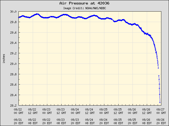
Still lightning ongoing in remnant eyewall. That tells me this thing is getting some upper level assistance and also that unusually deep convection for being this far inland will be efficient at mixing winds to the surface. Velocities over 90 kts showing on radar emphasize the wind potential this system continues to have. By all accounts, this is going to be one of the most prolific wind storms in the history of Georgia and possibly the upstate and mountains. I can see gusts of 70+ kts continuing into the mountains
-
And it does appear to continue wanting to deviate east of track. Could increase wind threat for Charlotte and Greenville down the line if that continues
-
That SE quadrant is benefiting from the 30 mph forward motion to keep these strong gusts going. I expect this to continue into the upstate and mountains. Augusta is about to get rocked, fully expect hurricane force gusts there
-
Looks like the main event is underway for the mountain and upstate areas. Will only go downhill the next few hours. Good luck to everyone in those areas and be safe
-
On the main thread some current obs gusting over 100 inland still!!! Wherever that core sets up is going to get wrecked with the saturated soils ahead of it.
-
Shows what that east side is capable of. I saw that gust report on the most recent advisory from NHC and figured you were in for a wild night
-
Probably 140 mph at this point


-
Wonder if this causes enough damage in the Clemson area to alter the game Saturday night


