

NW_of_GYX
-
Posts
1,025 -
Joined
Content Type
Profiles
Blogs
Forums
American Weather
Media Demo
Store
Gallery
Everything posted by NW_of_GYX
-
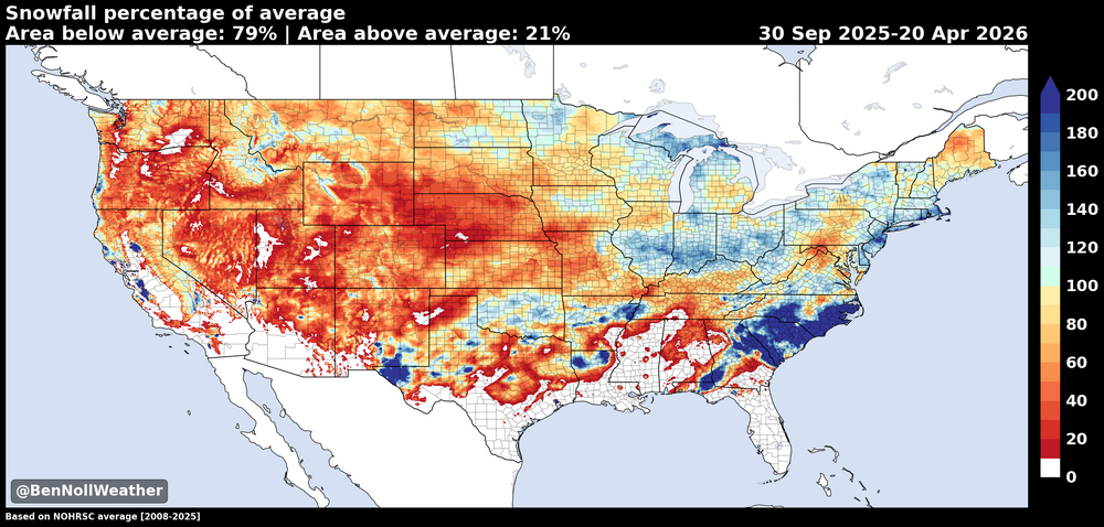
This may have already been posted but saw this on Opensnow’s season recap. Haves and have nots in the northeast fairly obvious. Not a good winter for Maine as a whole while the south coast did best relative to average.
-
White rain all afternoon but snowing again now and quickly coated up
-
34, SN. Maybe last of the season here?
-
Throttle pinned would be my recommendation
-
Lol, I treat that as a race gate
-
Winter lives on here, 10/10 today .
-
Plenty of snow on that side these days. Snowmaking upgrades plus boyne budget has made a big difference. Rumor has it will be open 7 days a week next season.
-
5.5” at home, about the same at pleasant Back to winter for a few days, photo from earlier this morning .
-
I need about 20” for average, possible I’ll get there but odds not great.
-
Same here. Temp dropped quick like @mreaves said it would
-
Flipped to snow here after briefly starting as rain. Will be tough to accumulate at 36 degrees though.
-
Snowy day at Bowdoin https://www.bowdoin.edu/webcams/coles.html
-
we hope
-
that area over to pen bay has had some great mesoscale events this winter
-
Nearly stationary funnel of moisture off the gulf, great to look at on radar. Is it amounting to anything on the ground?
-
I’m about 22” from my average at this spot since 2013. Certainly feasible but not guaranteed. If it happens, long duration cold plus best lake ice season since 2019 this winter could salvage a B-, otherwise it’s solidly in C category for this part of NNE
-
I’ve been tuned out for a while, spent last half of Feb in Hokkaido, Japan. That’s for another post. Looking ahead def some chances later in the month 19-26th? for the climo favored spots especially. We’re basically fully melted out here. Has been a cold but low snow year for the interior foothills into the mountains. Spots like Greenville are looking at less than 40” in January/Feb. that’s bad
-
That’s a high impact event for a decent portion of the upper Midwest
-
I’m at 62.5”. Difference is the December norlun and a couple other events where you outperformed. Wonder when the last time klew was ahead of the southern foothills/interior Cumberland county.
-
Overperformed here 2.25”. With Wednesday that’s 5.75” on the week, not a bad way to run a torch
-
It makes lots of noise too. Definitely a little spooky. Nice to be on skates so you can move quickly. But there’s at least 6” of ice on the whole bay so it’s very safe.
-
Stunning out there this morning .
-
Long fetch on that lake, need sustained night time lows well below zero, but even more importantly low wind. Big bay froze last year but was short lived and got smashed by wind
-
Count me in for the euro op look. This stretch has been great for lake ice but not snow. The big bay on Sebago is making legit ice for the first time in over a decade. Now lets relax the temps and get some snow where it wants to snow in peak climo, NNE
-
January 2026 regional war/obs/disco thread
NW_of_GYX replied to Baroclinic Zone's topic in New England
Cold morning, -13f


