ORH_wxman
-
Posts
93,098 -
Joined
-
Last visited
Content Type
Profiles
Blogs
Forums
American Weather
Media Demo
Store
Gallery
Everything posted by ORH_wxman
-
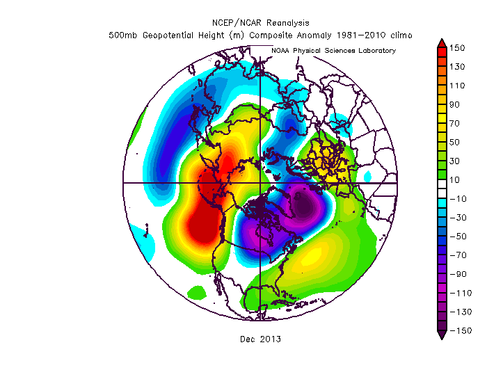
Even Dec 2013 wasn't exactly a Kocin Cookbook pattern, but we got walloped by a few storms that month
-
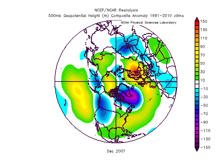
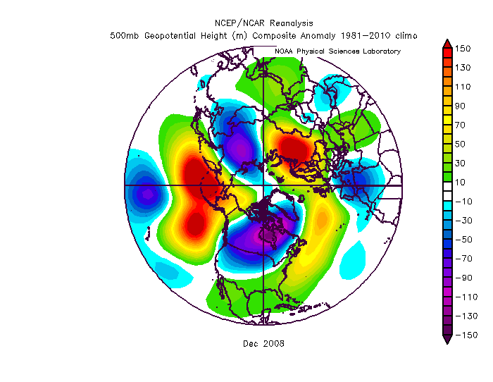
2008 was kind of similar too
-
Bummer, that puts all of New England out of the goods. There's always 2021-2022
-
I’d take the over at this point on 2035. We’ve basically had no trend in volume loss going back to 2010. You’d like to see something more discernible. Maybe there is another notable step-down currently in the works that will soon change the odds.
-
There's a lot of weak ice in the Beaufort/Chukchi region so I'd expect extent losses to accelerate again soon as a lot of that melts out and/or compacts, but we've lost any chance at a new record. I'm still expecting a top 3 lowest extent and area finish.
-
Euro seasonal is better than the others but in an absolute sense, it is still pretty inaccurate. It absolutely shit the bed last year even on the October and November versions IIRC. I also like to look at the H5 anomalies and not the 2m temp anomalies...they often don't seem in sync and the H5 anomaly forecast is going to be easier for the models to hit. IIRC, back in 2013-2014 and 2014-2015, it was showing these monster ridges over AK/EPO region (that largely verified) but they had warm anomalies in southern Canada and into most of the CONUS which is totally at odds with that pattern. So the H5anomaly was a lot more accurate for forecasting the sensible wx than the 2m temp anomaly.
-
I don’t think anything looks particularly bad. The N ATL cold pool is kind of annoying but it doesn’t drive the pattern...it can just act to reinforce a +NAO if it stays that way. Weak Nina is actually a pretty decent enso state. Most of the other stuff is pretty stochastic and not easy to forecast.
-
We’ve now fallen behind 2012 on both area and extent for losses. It didn’t take long to close the 800k extent gap. There is a good amount of weakened ice in the Beaufort/Chukchi sector, but I don’t see us finishing below 2012 on either metric.
-
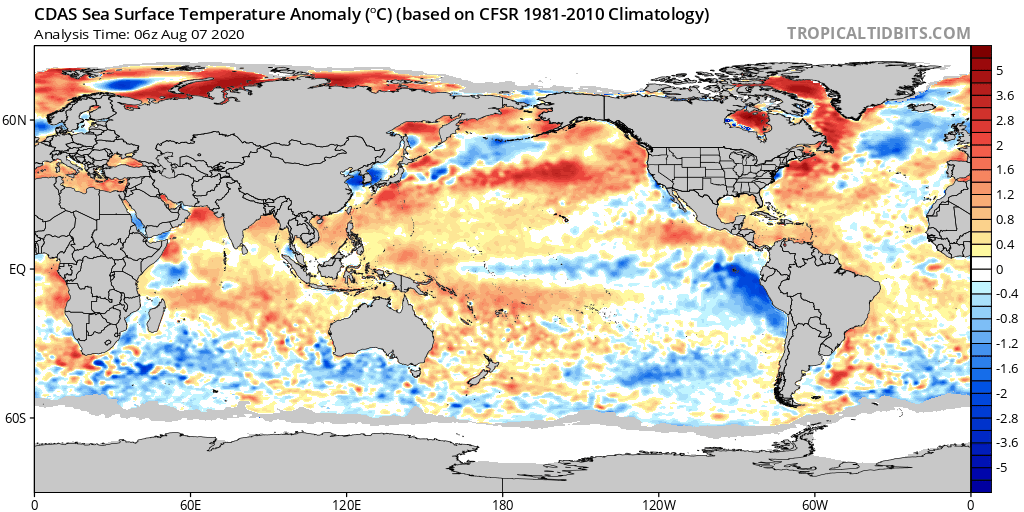
The ice bath sitting there in the N ATL doesn’t inspire a ton of confidence for the NAO. Hopefully it doesn’t end up mattering. GOA has been cooling a lot too recently though still above average while the warm pool south of Aleutians has been strengthening....wonder if the PDO will try and go negative this winter.

-
Yeah weak Ninas are good for snow in December. Ninas in general are good for snowy Decembers but you are right that the weak ones seem to have fewer duds mixed in. Dec 2016 was kind of near average. But Dec 2017, 2008, 2005, 2000, 1995 were all above average for the most part (2000 was kind of meh along the coast but good inland)...Dec ‘71 wasn’t great but Nov ‘71 was lol...and then the rest of winter was big. Dec 83 was similarly good inland but pretty mediocre right on the coast.
-
You weren’t supposed to tell them about our anti-VT group PM.
-
A lot of member social media groups are filled with chickenshits who either: 1. Want to stir up trouble for fun 2. Actually believe the crap they are typing but are too scared to say it without the “safety” of groupthink 3. Think their opinion is way more important than it actually is 4. Or all of the above. Agreed on the toxicity. No use wasting time in an environment like that.
-
If a local VTer told me to go home if I had a place there, I’d tell them to go f*** themselves and not think twice about it. Lol.
-
BDR and GON are pretty exposed. They might have some ok gusts.
-
I’ll be tracking the Tolland stem wind gusts with bated breath.
-
This storm looks like absolute ka-ka. I’d be surprised if there is much of any tropical wind core left by the time it reaches here. All gonna be hoping you get s LLJ max as it rapidly expands eastward.
-
It probably will. Or at least the warming there will slow. The N PAC has warmed faster recently than the N Hemisphere as a whole.
-
Its going to be inland for like 1,000 miles. Unless that drastically changes, this is primarily a big rain threat. If it stays over water somehow, then that means further east landfall over the cape or something. Outside of some southern facing exposed beaches, nobody is even seeing minimal sustained TS winds up in NY and New England.
-
I didn’t totally write it off. But as of now, it’s at the bottom of the list. There arent many scenarios where this is even a strong TS at landfall. The scenarios where the location is central/western CT have the storm tracking over the interior of the I-95 corridor so you don’t have any wind core left. Stronger scenarios are more plausible out east toward the cape if this stays more offshore.
-
Meh...dime a dozen in the other 3 seasons. I guess southerly 50mph on the coast in summer could cause a bit of damage. But the rain threat is 99% of this... You haven’t been through many New England TCs, have you?
-
Biggest threat is a PRE on this. The wind threat is lol up here.
-
That list I gave in vertical fashion was the good weak Ninas....not the ratters. Only ratter weak Niña is probably 1954-55...you could almost classify 2011-12 as one, but that was really a moderate Niña and it peaked pretty early. Of course everything else you said could be true as well. Maybe the warmer PAC outside of enso regions was reducing the effect. We did have a weak El Niño basically act like a La Niña a couple winters ago...but that has also been true in the past on a few events. Maybe it’s becoming more common now. We’ll need a higher sample to be sure. You've talked about the expanded Hadley cell...is it the dominant driver? Not sure. It definitely is a force that increases the gradient. But......Arctic warming faster than the rest of the globe reduces the gradient...that reduced gradient will want to offset an increased gradient from Hadley expansion. By how much? I don’t know. Will the PAC go back into a relative cold cycle again like we saw in the 2007-2013 years? That’s another question. I don’t think the N ATL going frigid on us since 2013 has done us any favors in terms of NAO blocking. You’d figure at some point the blocking will return...but outside of fleeting moments (March 2018...late Nov/early Dec 2019), we haven’t seen it during the winter months...not even during the “Labrador visits Boston” winter of 2015. I’m mostly thinking out loud in this post...we all know how difficult it is to predict winter here because New England has such a weird geography and no real Golden Nugget teleconnector. EPO would probably be our closest one to being that but even here we’re far enough east to not be in the direct line of fire like, say, the Great Lakes and upper plains are.
-
There’s been some subpar ones here but definitely minority. The monster ratter was 1954-55...least snowiest winter on record at ORH. 2005-06 and 1974-75 were OK but not great...1964-65 maybe slightly better. But a lot of goodies are on the list: 2017-18 2016-17 2008-09 2000-01 1995-96 1983-84 1971-72
-
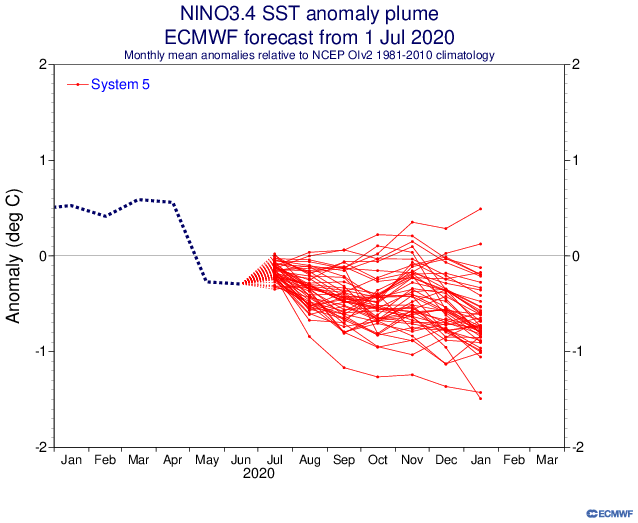
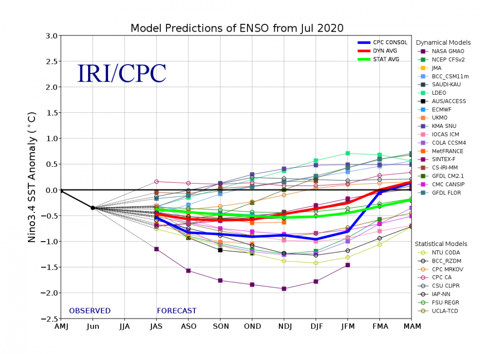
Most guidance still going for a weak La Nina....I was speculating on moderate about a month ago, but it seems we lost the easterlies and WWBs put a halt on it. But very recently, the easterlies have picked back up, so we'll see if there another late push to get things going. Weak La Nina can be very good though....some of our big ones in the past 30 years in weak La Nina have been 1995-1996, 2000-2001, 2008-2009, and 2017-2018
-
The reduction in extent losses was inevitable with how compact the ice had become (I made a post 5 days ago on this). However, we have had some good area losses recently, so there will be room for extent losses to pick back up if we can get another favorable pattern....for now, the reverse dipole looks to intensify over the next week, and then we'll see what happens after that.