


ORH_wxman
-
Posts
93,110 -
Joined
-
Last visited
Content Type
Profiles
Blogs
Forums
American Weather
Media Demo
Store
Gallery
Everything posted by ORH_wxman
-
haha....it was poking fun at his penchant for posting maps more relevant to NYC than to New England in the New England subforum.
-
There's one more panel for SE New England at 144....I'm banning for life you the next time you forget.
-
1/19-20/78....not even sure I’d qualify it as “widespread” 20 inches but BOS had 21.4 I think. It was their biggest snowfall on record at the time...a record that would last about 2 weeks.
-
I mean, there aren’t many January 20+ widespread events anyway in our region. They seem to be more common in Feb/Mar. Like for SNE, it’s really only 2015, 2011, 2005, 1996, 1978, 1961...maybe one more I’m forgetting? Don’t think ‘87 had a widespread 20 incher though the 1/2/87 storm had some pockets.
-
It was colder than our airmasses for the next week but i don’t think I’d qualify it as arctic. It was like -5C 850 antecedent. I don’t remember it being in the teens in that one. Maybe like mid 20s on the cold side of the CF.
-
1/12/11 off the top of my head. Prob not many others.
-
Dec (Edit: Jan1/..2 ) multi-faceted ptype mess potential...
ORH_wxman replied to Typhoon Tip's topic in New England
Cold layer below the warm tongue is pretty deep for the first several hours, so I wouldn't be surprised at a pretty good sleet-fest for a time. Esp in the zone between the pike and N CT/N RI. -
Dec (Edit: Jan1/..2 ) multi-faceted ptype mess potential...
ORH_wxman replied to Typhoon Tip's topic in New England
It was a late phase but the whole thing was much further southeast....and t ended up creating like a 700-800 mile firehose in the mid levels coming out of the east. Had 23 inches in that one in ORH. This one if it does phase and stall would happen much further north...it wouldn’t be an easterly firehose setup. It would be a rotting CCB/deformation. -
Dec (Edit: Jan1/..2 ) multi-faceted ptype mess potential...
ORH_wxman replied to Typhoon Tip's topic in New England
Could be a nice little sleet bomb for 3 hours here. Hopefully it starts as a couple hours of snow to at least whiten everything up good. -
I won’t hate on Forky for the snowblower comment...I used to think the exact same way but then I bought a house that happened to have a wrap around driveway...on a curve in the road (so the snowbanks get obscene)...LOL. Just brutal shoveling that. I did it the first winter in this house including 3 storms of 12”+ (1/4/18, 3/7-8/18, 3/13/18)...after that I said “never again”.
-
Never knew about the ethanol issues but I did notice my snow blower choking a bit last storm and was wondering if something was up with the motor. Ill have to try it from now on. There’s actually a gas station in town that sells ethanol-free gasoline.
-
Dec (Edit: Jan1/..2 ) multi-faceted ptype mess potential...
ORH_wxman replied to Typhoon Tip's topic in New England
The WCB on this one has looked kind of sickly on most runs. Not seeing that clean thump look. I think 6+ is going to have to be where CCB actions gets involved (not counting the upslope spots). -
Wow what a weenie run of the weeklies. 2nd half of January is all teed up on that look.
-
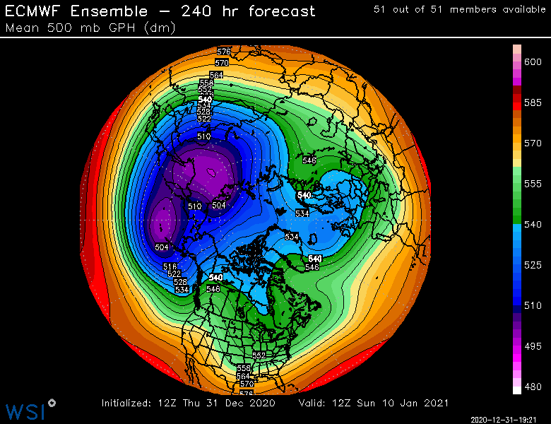
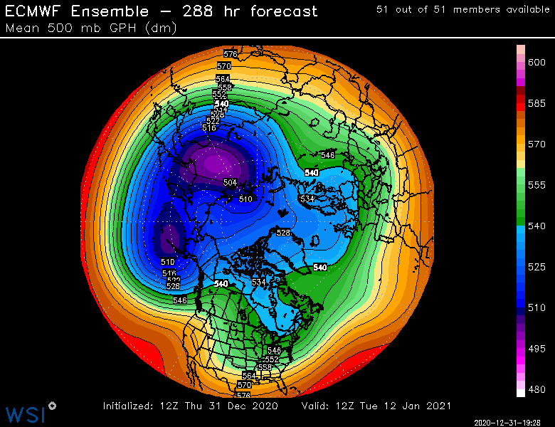
Many of the members must be breaking off a piece of the PV like the OP. I noticed the heights down in Ontario and our region look lower than previously. That’s obviously a good thing....even a little bit of fresh airmass enhancement goes a long ways when you have a block like that. A little more antecedent air can give a lot more wiggle room. Hopefully we see that trend stay on future runs.
-
Yeah plenty of ant-cyclonic curve on that
-
Yes. We did have a shorter lived block in Jan 2016 but it never got as intense as current model guidance is suggesting this one could be.
-
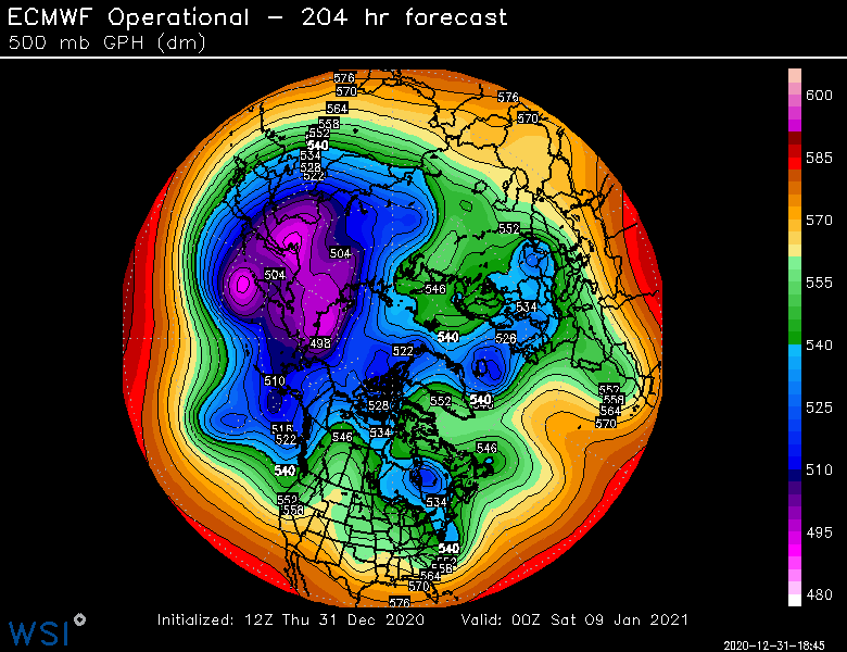
Did you see how this run breaks off a little piece of the PV around D4-5 and that actually then gets trapped in S Canada and keeps some decent cold around? You can see it sitting there just SE of Hudson Bay on the map I posted.
-
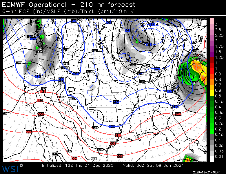
Davis Strait block....
-
At least wait until afternoon to hit the egg nog today. It's a long night.
-
Dec (Edit: Jan1/..2 ) multi-faceted ptype mess potential...
ORH_wxman replied to Typhoon Tip's topic in New England
I've noticed it runs a lot closer to the Euro than the old GFS in our winter storm threats....that's a big plus in my book. -
Only a few weeks until Tip starts making posts about how warm the interior of his car feels after being parked in the sun all day.
-
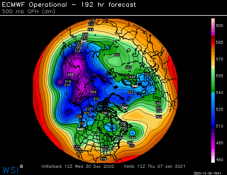
On a lot of runs the ridging kind of recycles and rebuilds at different times there rather than being this massive closed anticyclone. I wonder if that’s why the ensemble mean is more smoothed...because of the different timing of recycling ridges. Ideally, you’d have the closed anticyclone sitting right over the Davis Strait. There’s been a couple runs in clown range that have it but a lot of runs kind of look like the one I posted....where there’s a stout ridge there but it isn’t an immovable closed block...and it gets recycled a few times.
-
It would definitely be worrisome if we didn’t get an actual block...but the OP Euro has a legit Davis Strait block and so do several other models. When you see the ridging poking all the way back into northern Hudson Bay with the band of lower heights trapped underneath it, that’s what you are looking for....the lack of arctic air on our side of the pole makes it very marginal anyway for us, but without the block, we’d be in speedos and hammocks drinking pina coladas given how terrible the PAC is.
-
Dec (Edit: Jan1/..2 ) multi-faceted ptype mess potential...
ORH_wxman replied to Typhoon Tip's topic in New England
That is pretty snowy for pike northward on that RGEM run. 18z GFS render better for a inch or two on the front end as well for BOS/ORH. I’m still remaining mostly skeptical of the snow here for now until we get another tick colder. It’s not looking better up north of Rt 2 though for sure. -
Definitely a much more weenie-ish PAC at the end of the run.


