

ORH_wxman
-
Posts
93,099 -
Joined
-
Last visited
Content Type
Profiles
Blogs
Forums
American Weather
Media Demo
Store
Gallery
Everything posted by ORH_wxman
-
Yeah pretty much....this is weak. Still have to watch if guidance ramps up QPF in the final 24-36 hours since a lot of the analog setups are more robust....but it looks like this one is going to just be a C-1" deal for may....maybe a spot higher amount north of pike and then some FZDZ...maybe a pinger here or there.
-
Yep, the classic "pixie dust" sleet with frigid surface temps. You get these crappy flakes forming below the warm layer so the sleet is more like a 3 or 4 to 1 ratio.
-
More snow north.
-
The arctic cold in low levels is really impressive even at like 900-925mb....definitely more of a sleet sounding. You want torched 850s for ZR....these 850s are barely around 0C. You aren't getting ZR when you are barely above freezing in the warm layer and like -9C at 925mb, lol. That is a paint peeler if I ever saw one.
-
This definitely qualifies as a "warm bum-bums in the car" Tip post.
-
Wow that is an epic pellet-fest south of the pike that run.
-
GFS looking phase-y too....definitely going to be warmer.
-
NAM is still a little phase-y with the two streams.
-
Guidance has definitely been a bit too mild on most of our medium range threats recently. Best chance for icing IMHO is the freezing drizzle or light freezing rain on the first "system"...esp southern portions of CT/RI for Sunday/Monday.
-
It's pretty good about pike northward for warning snow, but it's not far from a lot more sleet. 06z EPS ticked north too.
-
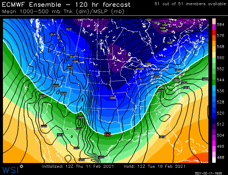
You can see the difference between the two camps.... Euro ------> warmer for 2/17, colder for 2/18-19 GFS ---------> colder for 2/17, warmer for 2/18-19 GGEM kind of in between. Hopefully we luck out and are just far enough north on both.
-
The 2/18-19 event is trending colder....that is likely to happen if 2/17 ends up warmer as the partial phase of the two streams in that event will lower the heights behind it a bit more.
-
If northern arctic shortwave doesn't get out ahead of the southern stream....it's going to be not much snow in SNE. Lot of sleet and ZR.
-
Yeah we want the two shortwaves to stay as separate as possible.
-
The guidance is moving toward the GGEM scenario from a couple cycles ago when it was trying to phase the arctic shortwave with the southern stream. Back then the GGEM was on its own...not anymore. This helps keep the midlevels torched a bit so there is more risk now for mixing/ice than before...and the chances of big warning snows on the front end decrease. We could still go back to the thump look...GFS has it and Ukie maybe but I see a clear trend here. We’ll see if that continues at 12z or not. FWIW, 06z runs kind of trended back just a bit so far. We’ll see what Euro does.
-
Slightly slower down south which tells me likely a little more amped than 12z if we extrapolated. But hard to say for sure. The Sunday system is still bothering me on guidance a little bit. Analog setups have decent QPF (like around a half inch for much of SNE)...so I’m wondering if that ramps back up a little inside 48h.
-
18z Euro is weak sauce for Sunday. Basically sliced QPF in half. Maybe an inch or two in the max zone.
-
BGM topography is better for rejuvenating rotting LES bands than a place like Ithaca is. Being further east also helps them a little more with synoptic coastals.
-
LOL...that was somewhat lucky to get it exactly....I just knew it was close to that because I went to school out that way and NWS BGM was our local office.
-
That one has been slowly cooling each run too the last few cycles.
-
What an arctic man high there.
-
Not too weird for them....they avg like 83.
-
EPS
-
One more tick and it won’t be a SWFE anymore here. More of a straight coastal.
-
Maybe. Depends how strong the thump is. This isn’t quite as far west as some typical SWFEs either.


