ORH_wxman
-
Posts
93,099 -
Joined
-
Last visited
Content Type
Profiles
Blogs
Forums
American Weather
Media Demo
Store
Gallery
Everything posted by ORH_wxman
-
I think even the interior would jump above freezing for brief time on the FROPA behind the system. But yeah, most of the precip damage occurs below freezing.
-
I’m tossing those types of runs until the evidence is very clear that’s what will happen. Seen this so many times where they try and track storms up Ginxy’s fanny only to see them go over the Cape or Islands once we’re almost on top of verification. Still gotta watch the mesolow potential too out ahead of it. Tomorrow’s junk could play a role.
-
18z NAM back to more of a furnace like the 06z run.
-
Yeah the hemispheric pattern is changing but it’s still pretty cold here through D10...we’ll see what happens beyond that but I wouldn’t be surprised if there are a couple legit threats in the Feb 22-26 time range.
-
Looks like less QPF than VDay 2007...that was a massive QPF bomb. I think I had like 8-9 inches of 6 or 7 to 1 snow/sleet combo. I also think midlevels are likely to be a little warmer so more ZR than that one. We’ll see though. Can’t rule out a late SE trend aloft.
-
Yes. I agree anecdotally with dendrite’s NAM rule...when it’s ripping in warm layers around 750mb, usually best to take it seriously. When it has the max warm layer much lower around 850, then we toss if other models are colder. And yes on the surface. Model guidance is overwhelmingly too aggressive in these situations in warming up the lowest levels. Maybe if a track from ginxy to Scooter actually verifies, then I might push the warmth further inland, but otherwise, bring ‘em down.
-
It actually has light crap off and on starting predawn tomorrow morning and then the steady stuff moves in early Tuesday predawn.
-
Euro is pretty cold too for 2/18. At the moment that one looks a bit similar to Tuesday except the PV which was originally supposed to settle in ahead of Tuesday, actually settles in after Tuesday and we have an arctic antecedent airmass which would be better for starting as snow.
-
Yeah it’s definitely been running colder aloft along with the Ukie. Suggests a lot of sleet N of pike...esp near MA/NH border. Prob starts as a burst of snow even. My gut tells me to go with the warmer models aloft though.
-
Secondary may tickle east on some of these runs like the RGEM. Not sure I’m totally buying a low over scooters head. Something like NAM makes more sense.
-
Yeah and that matches with my old radial anecdotes....I always noticed around a quarter inch radial is when you’d start seeing the scattered power outages and then at around 1/3 or 3/8ths is when it would start to seem to “ramp up”.
-
Yeah the new criteria using flat ice makes the warnings a lot easier to verify...and makes the warning a lot less menacing than it used to be. It’s still a pretty good icing event, but the old ice storm warning was like “whoa, this is pretty serious”.
-
Yeah, I was mentioning this earlier (I think yesterday) about the QPF aspect. I’d normally want to see at least 2” of qpf for major ice storm concerns unless it’s like 1.25-1.50 protracted out over like 36-48 hours from mostly light intensity stuff.
-
Yes the trend is def warmer in the midlevels.
-
Toss those sfc temps.
-
VDay 1962 was more impressive imho
-
Surface. It can torch aloft as long the flow is Southwest up there.
-
Pretty hard to warm the interior when it’s not mostly in-situ CAD. This is pretty classic pressure pattern to keep them well below freezing.
-
I think there’s multiple more chances in February. I mentioned earlier that 2/22 is starting to gain some traction. I agree with Scott that March looks warm and it makes sense but that could change too. Guidance has been pretty bad in the extended range. Lot of LR forecasters got humbled this year.
-
This isn’t a pure in-situ CAD event like we often see with a retreating high into Nova Scotia. It’s going to be really hard to dislodge cold in the interior. The only way will be if the primary trends west and stronger and you get a secondary trying track over like SE CT to RI to SE MA.
-
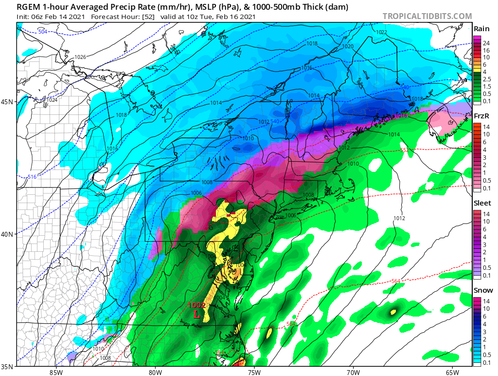
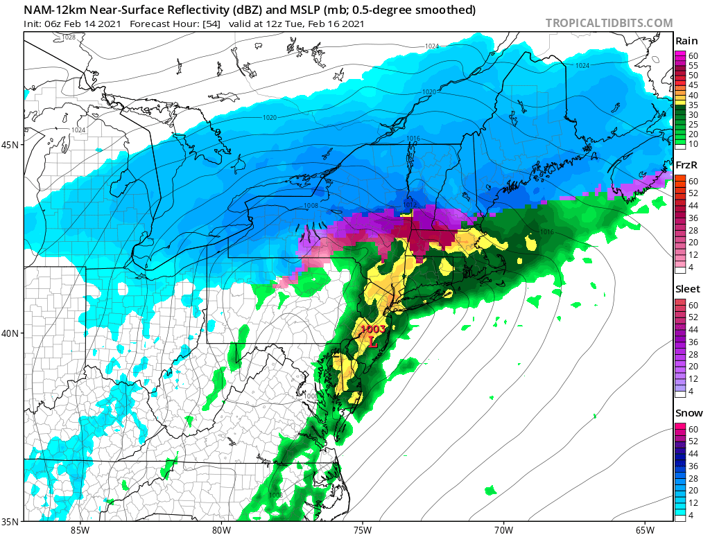
The guidance is going to verify too warm if they have that mesolow poking northeast into CC bay like the rgem does. If it’s a little less defined like the NAM then it’s prob going to transition to 33F rain further inland and ORH elevations will be the main area in SNE. Below are the rgem and NAM...you can clearly see the rgem points more NE while the NAM is more ENE. Euro was more northeast too which would end up colder. RGEM/Euro look means take ‘em down at the sfc

-
Euro looked pretty thumpy late week. Hopefully we trend that a little more. Also a potential threat 2/22...EPS has that. Looked Miller B-ish
-
This could be pretty icy over the interior. Gotta watch for the mesolow too. Some guidance is trying to poke a mesolow up to the northeast. Not all guidance (NAM doesn’t really have it but rgem and to lesser extent euro)....but if we pop that mesolow up into CC bay and northeastward, then it’s goodnight for warming above freezing at the sfc at least to like 128 and maybe even a little closer to coast.
-
Yeah maybe as high as 0.4-0.5 if it’s efficient. But this isn’t a major ice storm as modeled right now. Moves too fast and not enough QPF. Could be a decent nuisance type ice situation though. Around 3/8th radial starts getting annoying with some power outages.
-
I saw a couple threats that run. They just went wide right and one kind of redeveloped overhead. It wasn’t a particularly torchy run.