ORH_wxman
-
Posts
93,092 -
Joined
-
Last visited
Content Type
Profiles
Blogs
Forums
American Weather
Media Demo
Store
Gallery
Everything posted by ORH_wxman
-
December 2021 Obs/Disco...Dreaming of a White-Weenie Xmas
ORH_wxman replied to 40/70 Benchmark's topic in New England
Basically whole month of January would rock if that happened, but weeklies are not very useful beyond Week 2/3. -
December 2021 Obs/Disco...Dreaming of a White-Weenie Xmas
ORH_wxman replied to 40/70 Benchmark's topic in New England
Prob as soon as the -NAO shows up stronger on future runs. They'll whine their way to 50 inches in 3 weeks. Then they'll quickly forget it and irrationally fear the -NAO again next winter. -
December 2021 Obs/Disco...Dreaming of a White-Weenie Xmas
ORH_wxman replied to 40/70 Benchmark's topic in New England
The longer range beyond looks even better too than the Pre-Xmas pattern. That has some higher end potential than just the SWFE pattern. -
December 2021 Obs/Disco...Dreaming of a White-Weenie Xmas
ORH_wxman replied to 40/70 Benchmark's topic in New England
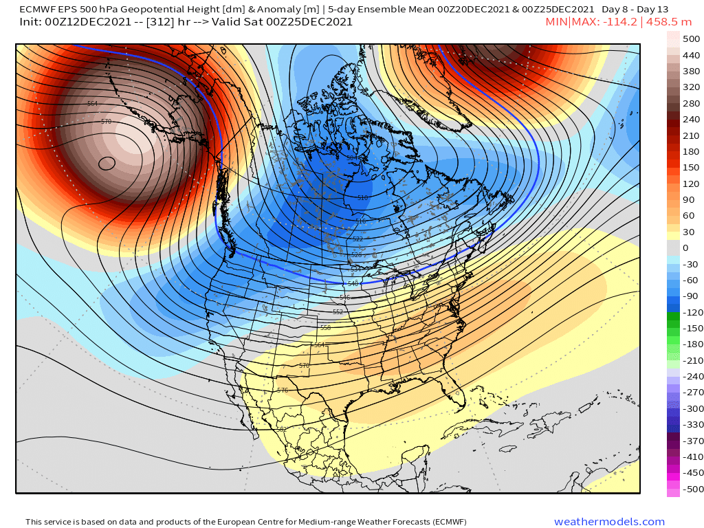
The NAO has definitely helped the overall trend the past few days in the mean H5 anomaly look leading into Christmas. Here's a loop of the 12z EPS the past 4 days starting Dec 10th and ending with today's run....you can see how much more stout the SE ridge was on early runs.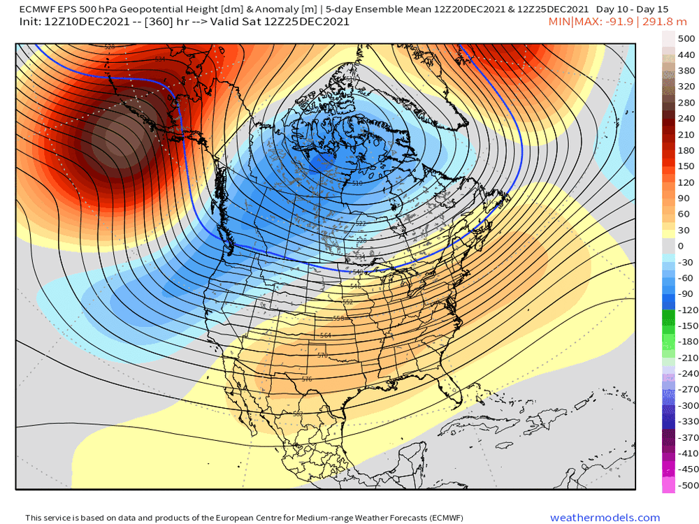
-
December 2021 Obs/Disco...Dreaming of a White-Weenie Xmas
ORH_wxman replied to 40/70 Benchmark's topic in New England
You can see it here....it helps force everything further south...some ensemble members are trying to show this so its something to watch. It would increase the margin for error if we get that look.
-
December 2021 Obs/Disco...Dreaming of a White-Weenie Xmas
ORH_wxman replied to 40/70 Benchmark's topic in New England
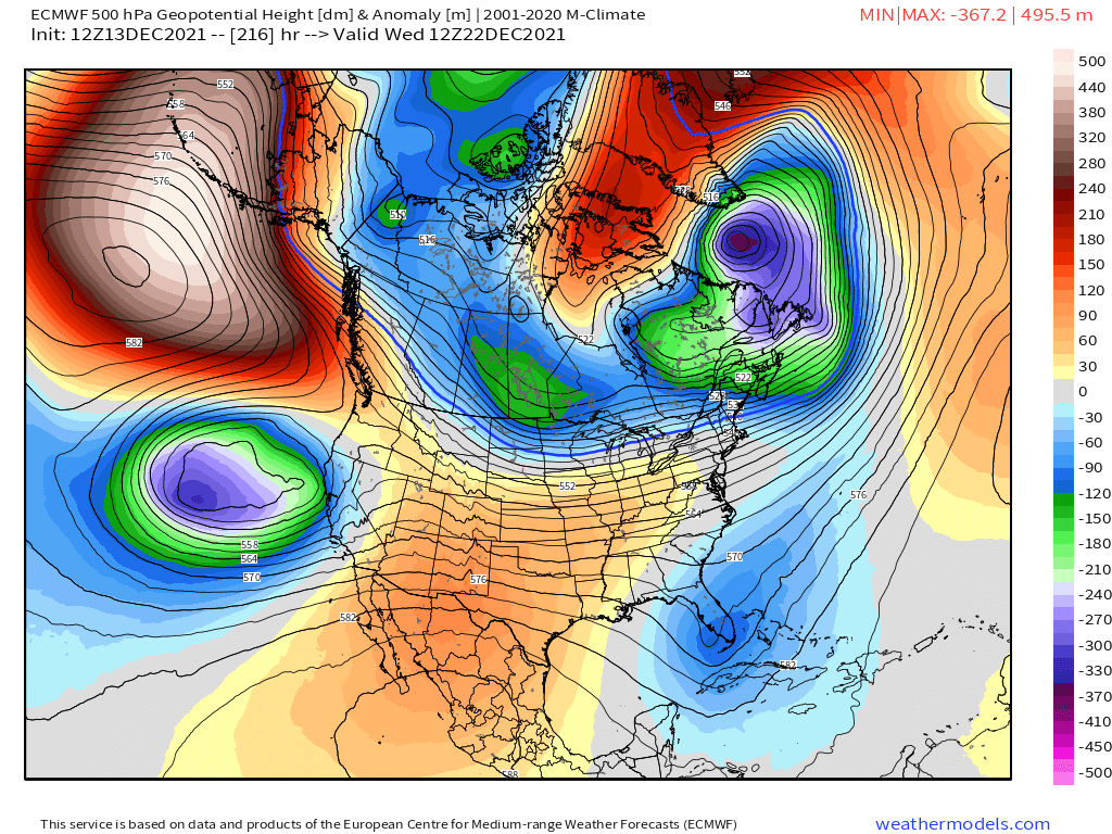
Damn, Euro is ripping a piece of that NAO block all the way back into Baffin Island/Hudson Bay by 12/22....that would make for some fun I think in the days following. -
December 2021 Obs/Disco...Dreaming of a White-Weenie Xmas
ORH_wxman replied to 40/70 Benchmark's topic in New England
All the western energy gets cutoff and sinks southwest into the Pacific, lol....I'd probably rather have that actually if we somehow manage to snow on 12/18-19 and have a pack to protect...it keeps everything northern stream which is better for us and better for avoiding cutters. -
December 2021 Obs/Disco...Dreaming of a White-Weenie Xmas
ORH_wxman replied to 40/70 Benchmark's topic in New England
Euro is def interesting for 12/18-19, but I'm not buying it yet. That's a low end warning event pike-northward on that run. It's just that we don't really get a solid flux of CAA prior to that event which is what makes me skeptical of the snow that far south. If future runs can give us a bit better push behind the FROPA this Friday, then maybe I'll start buying a bit more. -
December 2021 Obs/Disco...Dreaming of a White-Weenie Xmas
ORH_wxman replied to 40/70 Benchmark's topic in New England
Yeah unlikely we get skunked completely....esp once you are getting up into northern SNE. Long ways to go though before anything...even the 12/18-19 threat is 5 days out and most of us in SNE are not in the game with that threat....so we're still probably a week-plus out from our next snow threat. A lot can change. -
December 2021 Obs/Disco...Dreaming of a White-Weenie Xmas
ORH_wxman replied to 40/70 Benchmark's topic in New England
The 12z GFS is actually a great example to have right after the 06z GFS.....while the 06z GFS shows how things can go right, the 12z GFS shows how things go wrong. We're reliant on timing since we don't have true downstream blocking. That -NAO is still east-based so it's not going to provide much resistance for cutters....not until it retrogrades more into the central part of the domain which it might after Xmas....but prior to that, we are still at the mercy of timing. -
December 2021 Obs/Disco...Dreaming of a White-Weenie Xmas
ORH_wxman replied to 40/70 Benchmark's topic in New England
If it's beyond 3 days or so, that's probably the right approach. -
December 2021 Obs/Disco...Dreaming of a White-Weenie Xmas
ORH_wxman replied to 40/70 Benchmark's topic in New England
That was a great SWFE. Came in like a wall (so did 12/16/07 too 3 days later). I remmeber I was actually out running a couple errands and got back home just in time...it was prob around 11-1130am or so. Like a few weenie flakes were falling right as I pulled back in the driveway and then about 5 minutes later I looked back outside and it was S/S+....just ripping. -
December 2021 Obs/Disco...Dreaming of a White-Weenie Xmas
ORH_wxman replied to 40/70 Benchmark's topic in New England
There may be 2-3 chances between 12/18-12/25....hopefully we can cash in. The pattern is really active and there's a lot of cold bleeding in after the 18-19th. -
December 2021 Obs/Disco...Dreaming of a White-Weenie Xmas
ORH_wxman replied to 40/70 Benchmark's topic in New England
Looks good north of the pike....but my gut is that one ends up being NNE....we'll see though. -
December 2021 Obs/Disco...Dreaming of a White-Weenie Xmas
ORH_wxman replied to 40/70 Benchmark's topic in New England
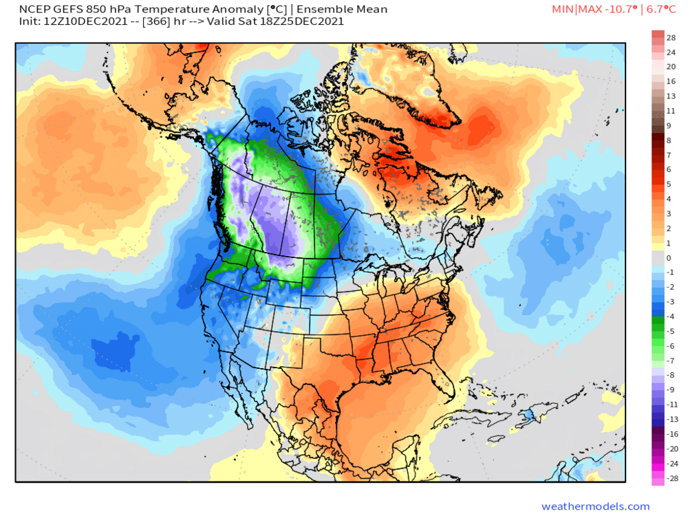
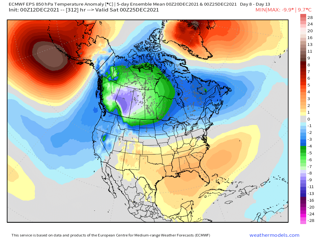
Here’s the 5 day 500mb anomaly mean ending 00z 12/25 and then the 850mb temp anomaly below that for the same time....we’ll have chances with that look but with the SE ridge, cutters are still a risk.

-
December 2021 Obs/Disco...Dreaming of a White-Weenie Xmas
ORH_wxman replied to 40/70 Benchmark's topic in New England
-
December 2021 Obs/Disco...Dreaming of a White-Weenie Xmas
ORH_wxman replied to 40/70 Benchmark's topic in New England
Definitely plausible. There’s pretty decent ensemble support for some potential wintry systems between 12/20-12/24 -
December 2021 Obs/Disco...Dreaming of a White-Weenie Xmas
ORH_wxman replied to 40/70 Benchmark's topic in New England
Euro/GFS/GGEM all have something to watch for 12/20 timeframe. They also have one for 12/18 but it seems like NNE might be the place to be for snow in that one. -
December 2021 Obs/Disco...Dreaming of a White-Weenie Xmas
ORH_wxman replied to 40/70 Benchmark's topic in New England
There’s always plenty of room for a grinch storm in there. Esp with that SE ridge still around. But at least there’s good cold bleeding down and it’s an active jet so we should have chances going forward after next week’s torch. -
December 2021 Obs/Disco...Dreaming of a White-Weenie Xmas
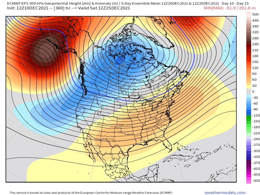
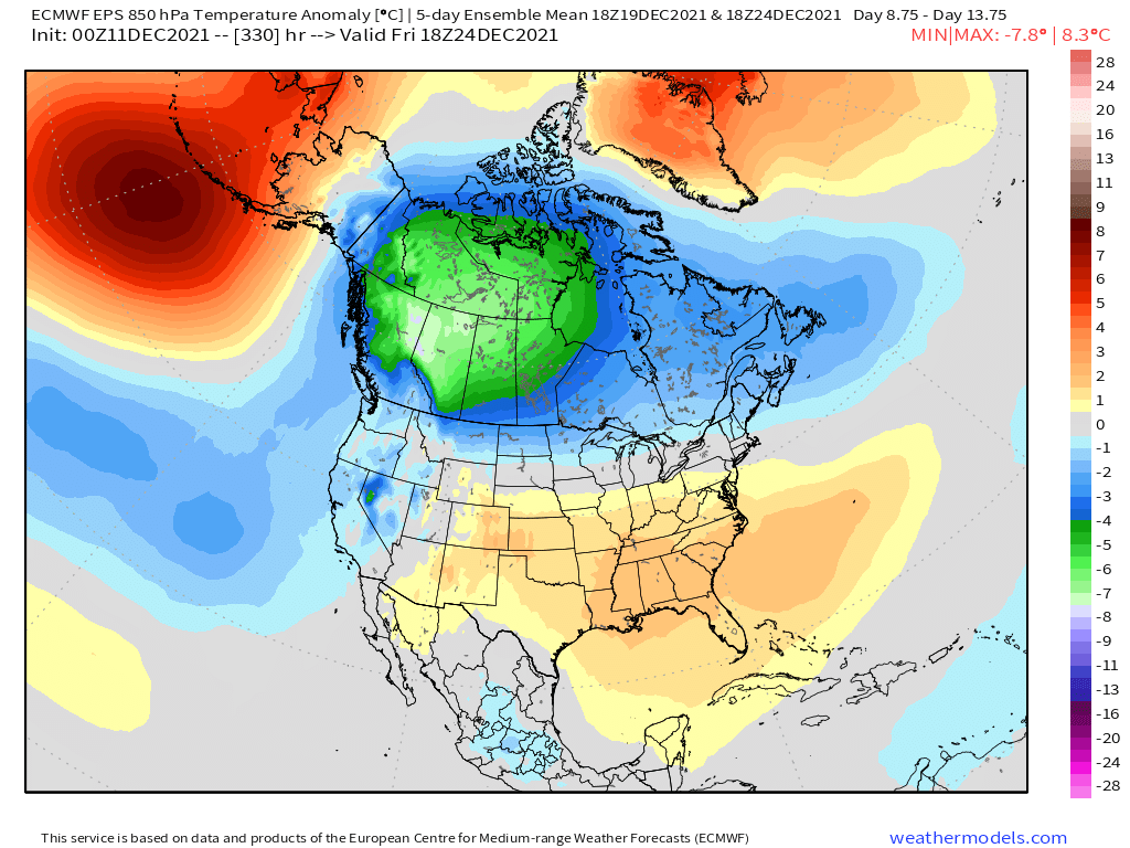
ORH_wxman replied to 40/70 Benchmark's topic in New England
This is the EPS 5 day mean ending 12/24 for both H5 and H85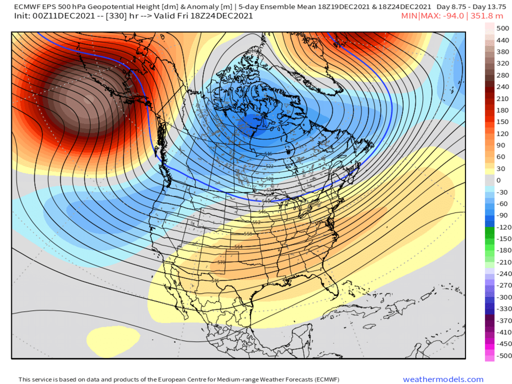

-
December 2021 Obs/Disco...Dreaming of a White-Weenie Xmas
ORH_wxman replied to 40/70 Benchmark's topic in New England
Ensembles on both GEFS and EPS show some potential there in that Dec 19-24 range. -
December 2021 Obs/Disco...Dreaming of a White-Weenie Xmas
ORH_wxman replied to 40/70 Benchmark's topic in New England
12/22-23/69 had a nasty ice storm over central MA. Prob the one. Dec 1973 is a good mention by the others but that was a full week earlier on the 16th. -
December 2021 Obs/Disco...Dreaming of a White-Weenie Xmas
ORH_wxman replied to 40/70 Benchmark's topic in New England
Yeah gotta go back to 2015 really....though you could maybe make a case for 2018 (first 10 days were brutal cold with the 1/4/18 bomb....however the rest of the month was a torch). Jan 2019 was cold, but not all that snowy. -
December 2021 Obs/Disco...Dreaming of a White-Weenie Xmas
ORH_wxman replied to 40/70 Benchmark's topic in New England
It's clown range but it's a very good look....esp for interior. That high is kind of moving east to coastline might have issues by the time the storm comes up the coast, but overall it's at least something that is plausible once we're done with next week's torch. -
December 2021 Obs/Disco...Dreaming of a White-Weenie Xmas
ORH_wxman replied to 40/70 Benchmark's topic in New England
The 850 anomalies show this well...it's not that warm here.