ORH_wxman
-
Posts
93,092 -
Joined
-
Last visited
Content Type
Profiles
Blogs
Forums
American Weather
Media Demo
Store
Gallery
Everything posted by ORH_wxman
-
It's frigid at 850 but the NAM has that warm nose at 750mb......looks like a scalping here.
-
Yeah the precip shield looks pretty cruddy when it's cold enough for snow...and it may never snow south of HFD. You'll prob start as some snow....it would be the type of thing where the cruddy precip shield has you starting as sleet, and then it goes over to snow as the better lift moves in and then back to sleet as the warm layer intrudes. But yeah the dynamics look pretty weak sauce, so I'm not expecting more than a couple inches here...I'd consider a couple inches a win actually. It wouldn't be shocking if its like 0.5-1" or something and then sleet crud for hours.
-
That one was like over OH Valley/W PA and it eventually sliced over New England....it was almost a coastal but further west.
-
December 2021 Obs/Disco...Dreaming of a White-Weenie Xmas
ORH_wxman replied to 40/70 Benchmark's topic in New England
There's a couple chances....the longer shot is 12/22-23....but there's a distinct chance at something 12/24-25 too....some guidance kind of has it more like 12/26....but there's a lot of shortwaves in the flow. The key is getting the -NAO to pin enough of a 50/50 low to force any potential cutters to our south. I also expect additional chances in the week to 10 days post-Xmas. You have that big -PNA just firehosing the flow with shortwaves into the NAO block. -
You never want to see the vortmax kind of sheared and tracking through Ottawa and Montreal for a big front end thump....you typically want that more consolidated and closer to us.
-
This also doesn't come in like a wall of S+ like some other SWFE...this is probably going to be putrid 1 mile type SN- with garbage flakes for the first 4-6 hours...it really doesn't start getting going until mid-event which by then, the scalping will be pretty far north.
-
December 2021 Obs/Disco...Dreaming of a White-Weenie Xmas
ORH_wxman replied to 40/70 Benchmark's topic in New England
EPS is actually grazing us with some light snow for next week’s 12/22-23 system. We’ll have to keep an eye on that one. -
Yeah it’s unlikely to be a huge issue. If we were getting double or triple the QPF it would be more interesting. Hopefully guidance cools a tick today because ZR is pretty useless. But I’m guessing the midlevel warming trend will actually continue at 12z. I’m just hoping for a couple inches here before the flip but it’s looking precarious.
-
There won’t be a lot of glazing in this event. Of course, it doesn’t take much to be dangerous, but I’d be surprised if any glaze was more than a couple tenths. Not a classic look for big ice.
-
Rgem looked a little cooler than 18z. edit: Bristol beat me to it
-
December 2021 Obs/Disco...Dreaming of a White-Weenie Xmas
ORH_wxman replied to 40/70 Benchmark's topic in New England
We need mainejayhawk to make a gif of George Bailey running through downtown in the snow and photoshop a scooter head on it. -
18z euro ticked warmer. Took CT out of the advisory snows except maybe far N CT.
-
December 2021 Obs/Disco...Dreaming of a White-Weenie Xmas
ORH_wxman replied to 40/70 Benchmark's topic in New England
Miracle on Scooter Lane? -
December 2021 Obs/Disco...Dreaming of a White-Weenie Xmas
ORH_wxman replied to 40/70 Benchmark's topic in New England
Scooter white Christmas saved on 18z gfs. -
ICON tickled colder at 18z if we even give a sh*t about that model....it was one of the warmer ones at 12z though....so we're seeing some convergence now (RGEM coming in warmer after being one of the coldest models too).
-
RGEM looks like it's tickling warmer on the 18z run. It was pretty cold at 12z with like 3-4" down into central CT....this run is giving the advisory snows mostly along and north of the MA/CT border.
-
December 2021 Obs/Disco...Dreaming of a White-Weenie Xmas
ORH_wxman replied to 40/70 Benchmark's topic in New England
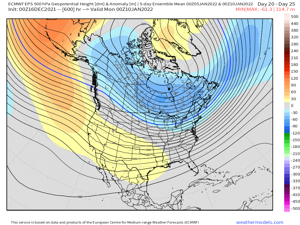
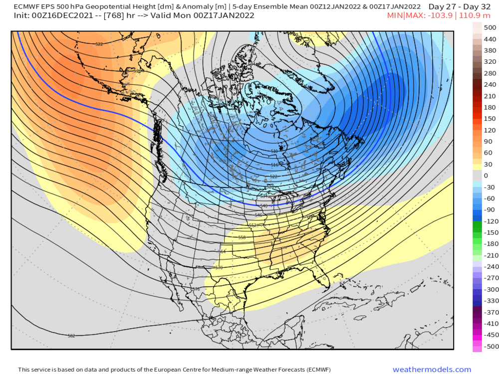
Weeklies are pretty nice....they shift the PAC/Aleutian ridge eastward in January so it's more over the GOA and EPO region...so we lose the deeply negative PNA trough. Here's the 5 day mean Jan 10th and then the same thing for Jan 17th...note how the ridge moves eastward. This is getting pretty far out there but that would be a good time for that to happen as they start to lose the NAO blocking
-
3km NAM was actually decently colder than the 12km on the 18z run.
-
December 2021 Obs/Disco...Dreaming of a White-Weenie Xmas
ORH_wxman replied to 40/70 Benchmark's topic in New England
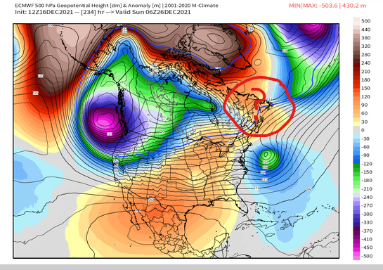
Here's a visual of the 12z OP run and the EPS....notice how on the EPS, you see the PV lobe anomaly pinned underneath the NAO block up in the Maritimes/New Foundland but on the OP, it's nada.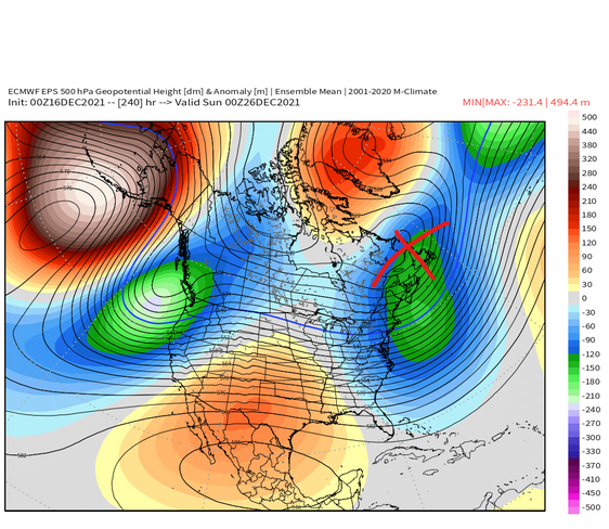
-
December 2021 Obs/Disco...Dreaming of a White-Weenie Xmas
ORH_wxman replied to 40/70 Benchmark's topic in New England
OP euro solution is kind of ugly in that the southern stream gets totally isolated and cutoff but the fact there is a storm there is good to see. Even with those flaws, it's pretty close to a good event. One of the flaws on this run is that a chunk of the PV that was previously getting pinned under the NAO block actually retrogrades back west into the PNA domain, which gives us a worse airmass to work with too. -
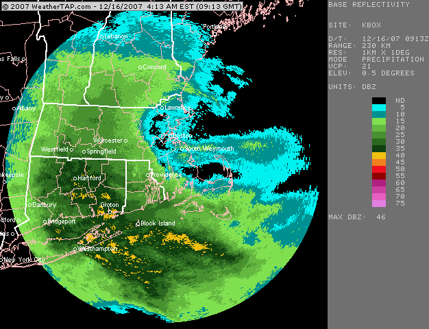
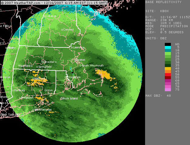
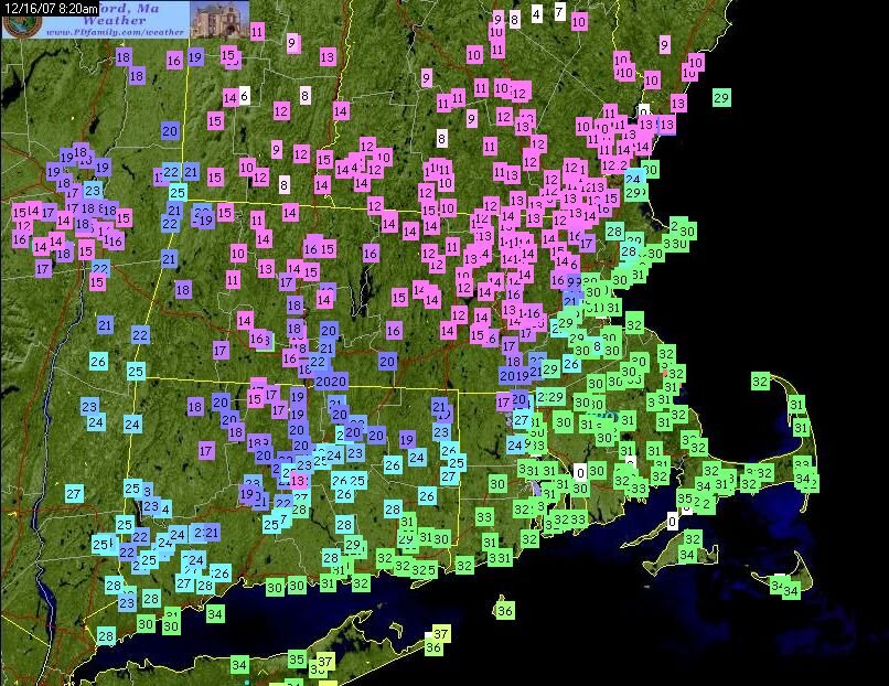
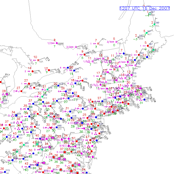
Nice write up 4seasons....that band up in NY and into VT?NH was one of the most ridiculous mesobands I've ever tracked. Not to be forgotten either is the anniversary of the 12/16/07 bust....mostly 2-4" amounts were forecast for SNE...and while that was fairly accurate down in southern parts...much of MA/N RI busted way positive....with 6-10" for a large area. While we didn't have dual pol CC back then, we could still see the yellows washing out near the southern MA border....this was very heavy snow too with good dendritic growth....2" per hour stuff. First image is just after 5am....and then the second image is 2 hours later....not a lot of headway made on the sleet line. Then that storm also had a crazy tight coastal front...and finally my favorite image is the sfc plot that shows sleet up in upsate NY while it's ripping snow on the Cape.
-
Doubt it...dryslot punches in pretty hard from the WSW. Might get a few flurries on the back end, but nothing meaningful unless this trended further south.
-
You've been pretty consistently in the 3-5/4-6 zone on almost every run save for a couple scaryish torch runs. I wouldn't be sweating there too much regardless. Worst case scenario for you is prob like 2" with several hours of scalping BBs....more likely you'll prob get a good high end advisory thump Also, the snow maps are more sensitive in ORH county because the sfc temps there are cold...so any run where the warm layer aloft is colder/warmer will affect the totals more. Your area is prob getting a slight penalty on various clown maps for sfc temps near or just above freezing (I'll take the under...you'll prob be a couple ticks below freezing in reality)....so even a "Colder" run aloft, doesn't help you as much as it should.
-
I'd sign on the dotted line if I could make this run verify...I'd take 3-4" with some IP/ZR in there and run. Need another tick colder though before we get those NAM runs 30 hours out that have the chickens getting pelted with BBs.