ORH_wxman
-
Posts
93,095 -
Joined
-
Last visited
Content Type
Profiles
Blogs
Forums
American Weather
Media Demo
Store
Gallery
Everything posted by ORH_wxman
-
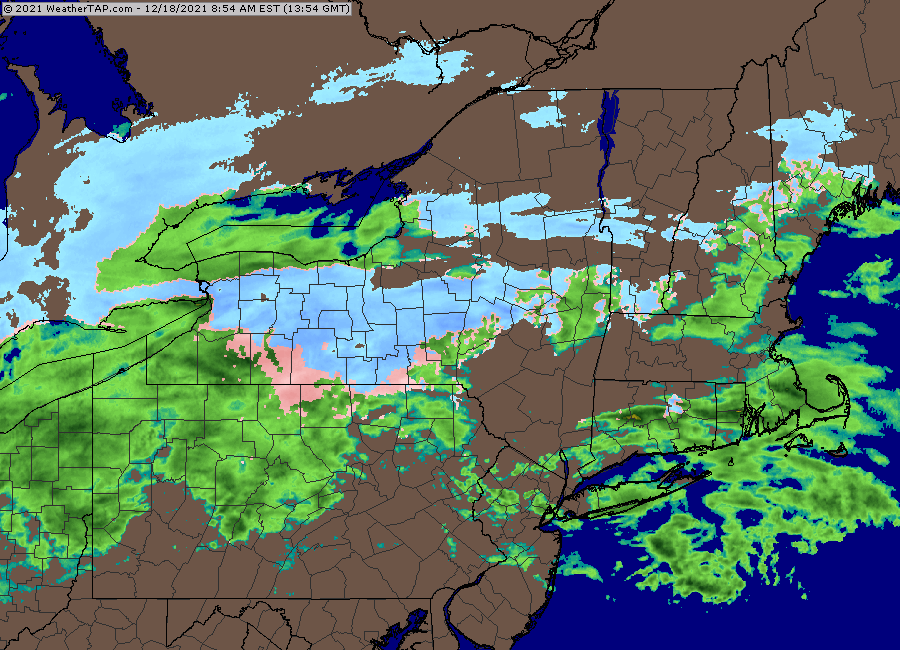
This one is fugly. Look at this precip shield. But this is what you get when it’s a sheared vortmax going through Ottawa.
-
December 2021 Obs/Disco...Dreaming of a White-Weenie Xmas
ORH_wxman replied to 40/70 Benchmark's topic in New England
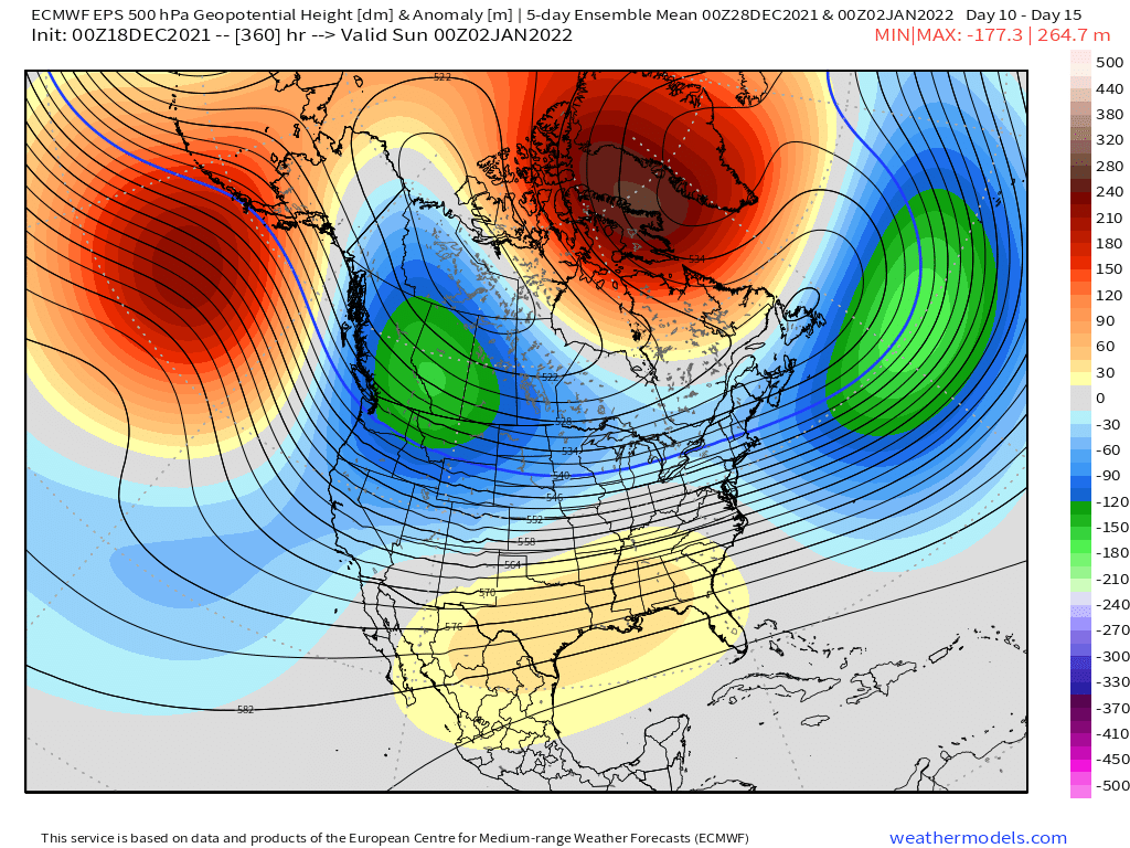
Yeah +250dm anomaly on a 15 day mean. That’s the type of stuff we used to see in the 2010 blocking days. -
December 2021 Obs/Disco...Dreaming of a White-Weenie Xmas
ORH_wxman replied to 40/70 Benchmark's topic in New England
D10-15 mean pushes that PNA height anomaly a bit east/inland and that NAO block is in an ideal location.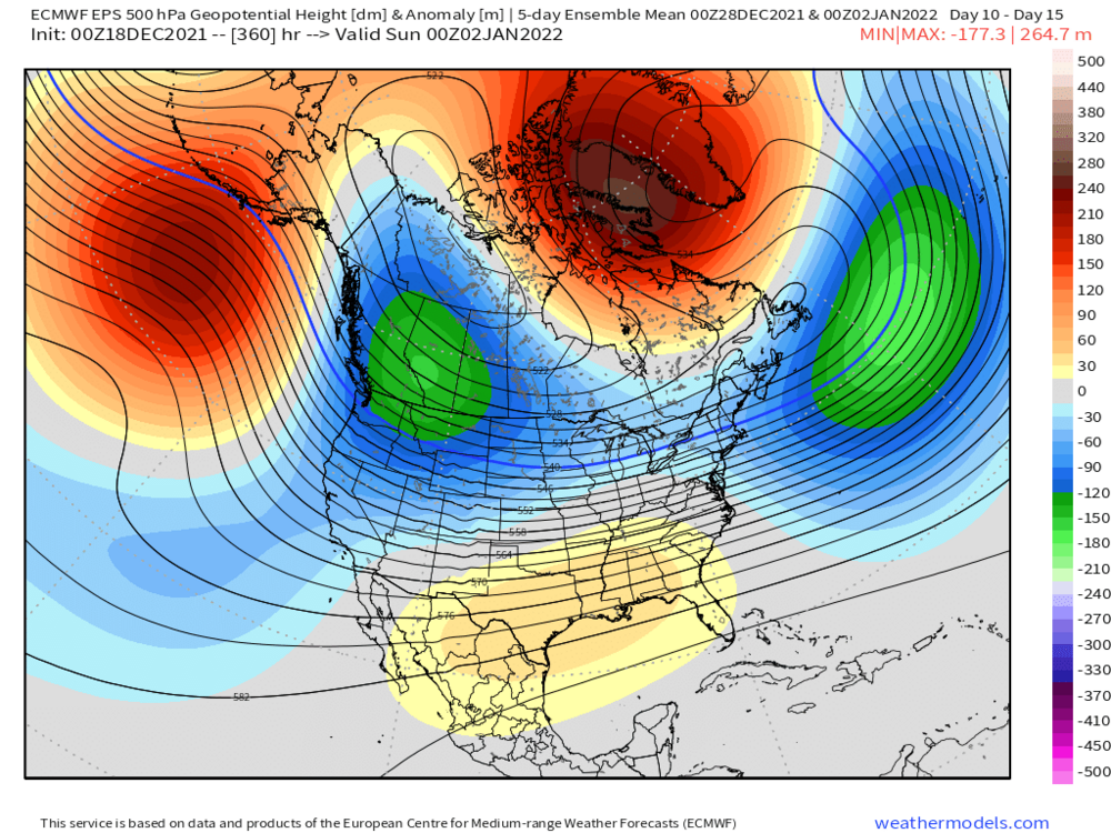
-
Is Kevin getting a burst of snow? Looks like that precip is snow on CC. Or he’s right near the line.
-
December 2021 Obs/Disco...Dreaming of a White-Weenie Xmas
ORH_wxman replied to 40/70 Benchmark's topic in New England
Pattern looks amazing on the EPS going forward regardless of any potential grinch on Xmas. I’m pretty confident we will cash in at some point on that look. -
December 2021 Obs/Disco...Dreaming of a White-Weenie Xmas
ORH_wxman replied to 40/70 Benchmark's topic in New England

-
When he does the swan dive off the building.
-
Ray just pulled a Bill Murray in Groundhog Day.
-
Bit of an IVT as it exits with moisture trapped below 800mb....so yeah, might be some snizzle or even some light snow for a time early Sunday morning. It's only like -5C...so questionable how much snow there is, but prob a lot of salt nuclei in that given it's in the low levels and -5C is prob cold enough with lots of salt nuclei.
-
18z NAM looked slightly less offensive with the warm nose aloft down here in the early going...so it actually gives us an inch or two versus very little on the 12z run. However, the 3km wasn't interested in throwing us that bone.
-
December 2021 Obs/Disco...Dreaming of a White-Weenie Xmas
ORH_wxman replied to 40/70 Benchmark's topic in New England
It’s good for holding in a semi-permanent 50/50 feature. You can see where that low height anomaly is now just E of new Foundland. It becomes pretty hostile for cutters. -
December 2021 Obs/Disco...Dreaming of a White-Weenie Xmas
ORH_wxman replied to 40/70 Benchmark's topic in New England
The NAO block is in a better spot than a few days ago. That west-based look with a -PNA is really good for us usually. -
December 2021 Obs/Disco...Dreaming of a White-Weenie Xmas
ORH_wxman replied to 40/70 Benchmark's topic in New England
The primary is in Lake Superior at 216 hours....lol. But the block forces a secondary to develop off NJ. -
December 2021 Obs/Disco...Dreaming of a White-Weenie Xmas
ORH_wxman replied to 40/70 Benchmark's topic in New England
This entire pattern is going to be difficult on model guidance because of the -PNA firehose running into the NAO block....at any time, one of the fragments of energy ejected from the western trough could become a player, but the model guidance can't really tell which one it is this far out. That's not even counting how model guidance handles the block itself...nuances in the orientation of the block can have large sensible wx effects. -
December 2021 Obs/Disco...Dreaming of a White-Weenie Xmas
ORH_wxman replied to 40/70 Benchmark's topic in New England
Euro has a weak impulse in the flow that tries to give a little light snow overnight Xmas eve into Xmas morning, but it's just a shade dry. More like snow showers. But again, those things are not going to be modeled well, so worth watching if it can turn into something bigger. -
Definitely lost the to GFS in the 96-120 timeframe....so a bad showing by the Euro. Confidence not restored after its win last week.
-
Yeah it was better for everyone N of rt 2....it wasn't much difference here, but it trimmed the 1-2" amounts down in CT/RI
-
The WAA has a harder time the further east you get....this isn't like a usual coastal.
-
Euroi ticked warmer again....pretty big juice-up in QPF though...so that's gonna be better for those who can stay snow long enough to take advantage.
-
December 2021 Obs/Disco...Dreaming of a White-Weenie Xmas
ORH_wxman replied to 40/70 Benchmark's topic in New England
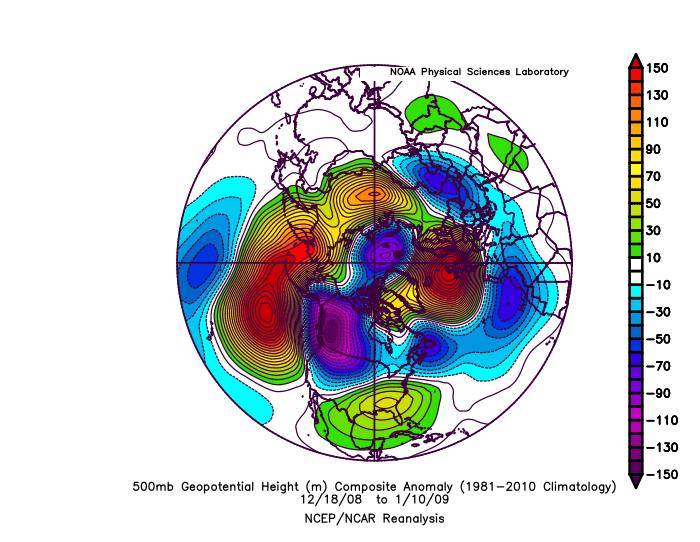
And here;s another....one that didn;t work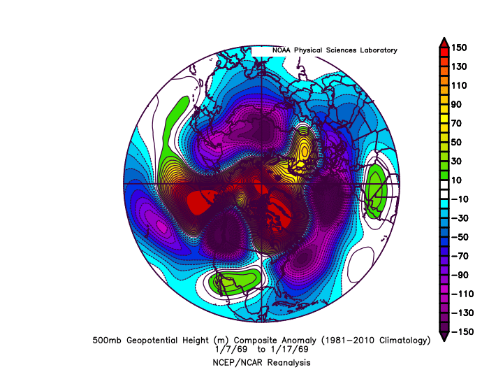
-
December 2021 Obs/Disco...Dreaming of a White-Weenie Xmas
ORH_wxman replied to 40/70 Benchmark's topic in New England
Here's a couple similar patterns: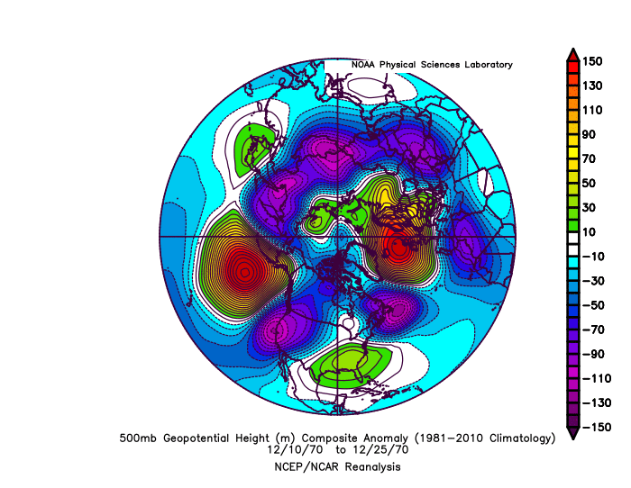
-
December 2021 Obs/Disco...Dreaming of a White-Weenie Xmas
ORH_wxman replied to 40/70 Benchmark's topic in New England
Canadian tries to redevelop a clipper on Xmas even to our south....that would prob be enough for white Xmas for most of us. These types of embedded shortwaves in the fast flow are going to be hard for models to resolve at this lead time. The pattern definitely gets even better after Xmas, but I wouldn't sleep on the 12/24-12/25 potential yet. -
December 2021 Obs/Disco...Dreaming of a White-Weenie Xmas
ORH_wxman replied to 40/70 Benchmark's topic in New England
Yeah I'm more interested in the train of shortwaves between 12/24-12/27. I'm hoping one of the early ones can deliver for Xmas, but I'll take any of them delivering. -
December 2021 Obs/Disco...Dreaming of a White-Weenie Xmas
ORH_wxman replied to 40/70 Benchmark's topic in New England
We're gonna have Tblizz listening to White Snake before too long while he watches the models whiff us one after the other.