ORH_wxman
-
Posts
93,092 -
Joined
-
Last visited
Content Type
Profiles
Blogs
Forums
American Weather
Media Demo
Store
Gallery
Everything posted by ORH_wxman
-
That streamer goes all the way through S ORH county and to near UUU.
-
Beast must have gotten several inches? That streamer seemed to be near them oscillating all night.
-
LL lapse rates are like 9C/km tonight....watch for windex squalls up in NNE/CNE...they may get down to the pike region in SNE, but I'd def favor further north toward Ray if anything was gonna happen in SNE. Too bad we didn't have a little more moisture pooling or it would have a chance to be higher end.
-
That is a very realistic possibility.
-
Agreed. There are going to be plenty of chances though it looks like. There seems to be another potent shortwave behind the weekend deal too if that one fails.
-
I mean, that’s pretty much exactly what I’m getting?
-
I didn’t quite have that much. About 10.5 here. Prob 5-7 miles S in Milford had a foot though. They spent longer in that great band.
-
I mean, i prob only had about 0.2 extra of QPF? You prob had around 0.4 and I had maybe 0.6? 0.7 if generous.
-
It’s still full coverage here. 3-4” of dense ripe snow in most spots though maybe more like 2” in the most exposed yards on the street. Glad the ice pack is off the driveway though.
-
Ensembles have a super strong signal at the end of their run which is like 1/24 or 1/25. Prob no true breakdown until February if that is close to correct. Things can always change though. We’ve seen that enough already this season. But I’m pretty optimistic.
-
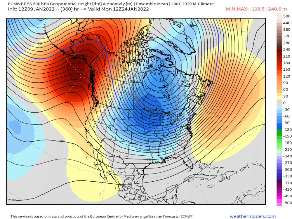
Can’t believe how strong the anomalies are in the EPO region for that far out. Very strong signal.
-
I would never guarantee at 5 days out that you are good. But right now Friday looks fine…but definitely keep checking.
-
EPS looks like a super cold pattern for a lot of the CONUS at the end. That’s major arctic express there
-
Euro actually had some really light snow with that. Even a stripe of 1” or so along rt 2 and prob a coating for pike region. But it needs some help to be more than a nuisance. Definitely possible though.
-
Good signal on EPS but plenty of spread a week out


-
No that is the first system that is a longer shot imho. It could produce something but I’d favor the one behind it which would be next weekend.
-
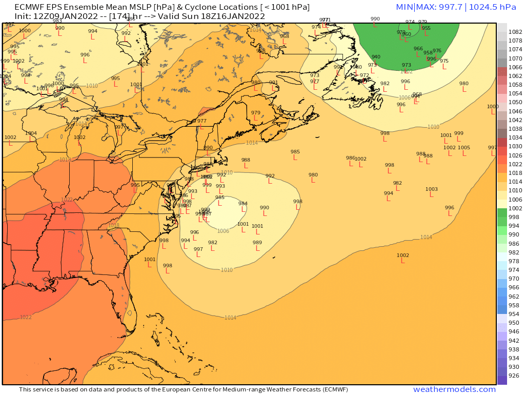
Gets shunted way south but that’s a nice look overall. I like the really strong northern stream there.
-
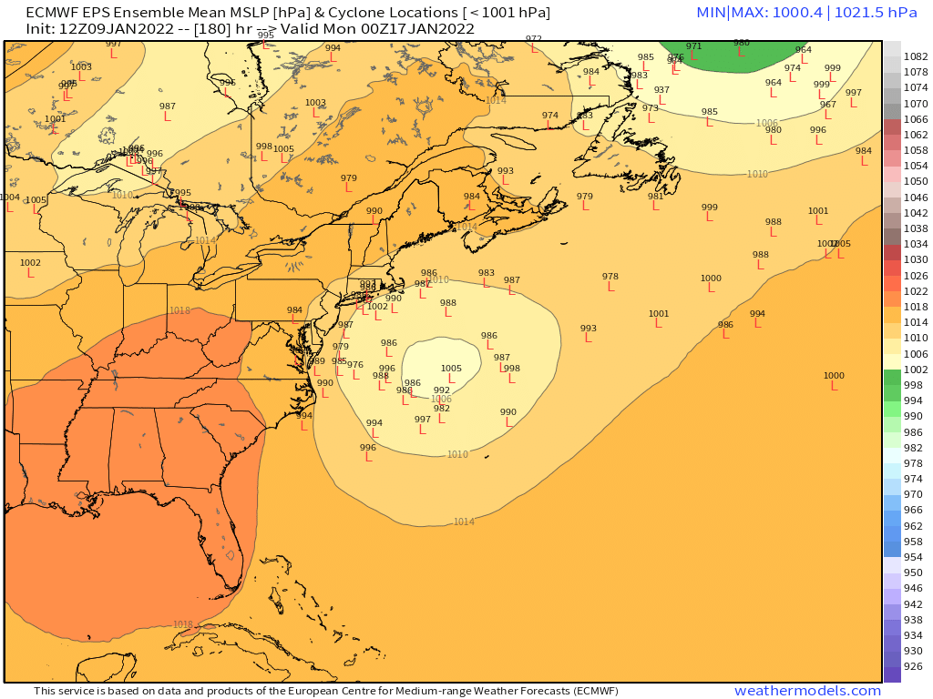
Euro is definitely cooking up something big at 156 here.
-
Yeah this is a lot of shortwaves in the flow. I feel like the event afterward has more support but can’t ignore the Thursday night/Friday deal just yet.
-
My pack is getting pretty ripe/dense. No longer a fake effect fluffer pack. Around 5-6” but it’s gonna be a glacier by tomorrow morning. It’ll make a good bottom base layer on our march to 3+ feet OTG by early February.
-
Up to 39 now. Ice almost totally gone from driveway.
-
Nice stalled Miller b on GGEM. Lol
-
The near-sfc in-situ CAD ZR events don’t accrete on elevated surfaces very well because the drops aren’t supercooled. Literally a few hundred feet up is probably above freezing. Usually when the cold is a bit deeper, the drops become supercooled so they freeze on contact with trees and power lines. In this case, they need some time to glaze, so they drip down and mostly freeze on the ground.
-
37 and light rain here. Starting to get some of the ice melted off the driveway.
-
Up to 32F here now. Doesn’t look like ZR will be a huge factor thankfully. Driveway is already pretty icy from hard packed snow that turned into a glacier so hoping a few hours of 35-40 can take care of that.