ORH_wxman
-
Posts
93,092 -
Joined
-
Last visited
Content Type
Profiles
Blogs
Forums
American Weather
Media Demo
Store
Gallery
Everything posted by ORH_wxman
-
It’s solution is pretty close to the EPS mean so it’s not like it’s an outlier. Definitely well within the realm is solutions.
-
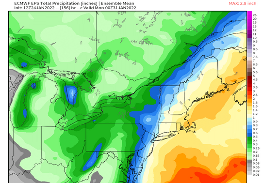
Looks like an inch or so
-
There is a nice cluster now on the 00z GEFS that is up toward ACK that was not on the 18z run

-
Lol no....I'm just much less afraid of a storm ripping up through ORH than before today. A hugger near the Cape is still a very real distinct possibility, and you don't even need it that far northwest where you are since this is hooking left into the Gulf of Maine....a lot of these solutions that track outside the Cape still hit NH pretty hard like the 00z Ukie.
-
Yeah today the trends were pretty decidedly against a 100% southern stream phase. Gotta update the priors. The question is now how much of whatever less than the 100% do we incorporate into the system. I guess something else weird could change in the northern stream but it seems to be pretty steady on most guidance.
-
The storm is going to be nearby…we know that much. Really the only major variable right now is still how much southern stream gets incorporated. It’s the difference between maybe a scraper and a cape track roughly. That’s where the realistic goalposts are imho. If we want to get super weenie-ish about 2 standard devs you could prob extend the goalposts a little further to a whiff and maybe something tucked near BOS but that’s getting fairly low probability.
-
That was def a jump west on Ukie.
-
Even some of these sloppier half-phased solutions are crazy strong. Just shows the higher end potential on this…esp if it gets captured by a closing off H5 and temporarily slows down.
-
They are all in an unmarked box somewhere next to the Ark.
-
It probably got put in the same storage warehouse as the CRAS model.
-
It seemed like every storm that winter I was migrating down there by 4 days out when I saw the writing on the wall up here. But it was fun tracking some of those. You even had kind of a pseudo-SWFE down there where I came in and kept saying “stop worrying that it will hit NC and S VA, this is easily going to trend north.” I think you all got like 8-10” of fluff out of it. It was like a week before the big dog.
-
He’s already gotten enough taste of that since last year and now needs to go for a few kills…jackpot a couple storms.
-
Yeah I probably wouldn’t go into weenie mode on the air until about 72-84 hours out. Though I’d definitely be dropping hints at D5.
-
I think the important point you missed was we used the NAVGEM as the tiebreaker.
-
Yeah 18z euro looks like it would be a bit more amped than 12z. Def didn’t follow the 18z GFS
-
Meteocentre has the 18z gem but it only goes out to 84h on the 18z run.
-
JJ Foleys FTW. My favorite is when they politely told all of us “gentlemen, we think you may be more comfortable in our back room”…they were so diplomatic kicking us out of the main bar.
-
If this storm is in the process of hooking back toward the Cape during that time, it could be an epic tide.....major coastal flooding.
-
Winter storms are too frequent here to name them...and if you aren't following TWC all the time, you'd have no idea anyway, but most people do remember the date (or close to the date) that something happened. They aren't required to watch TWC to remember it either.
-
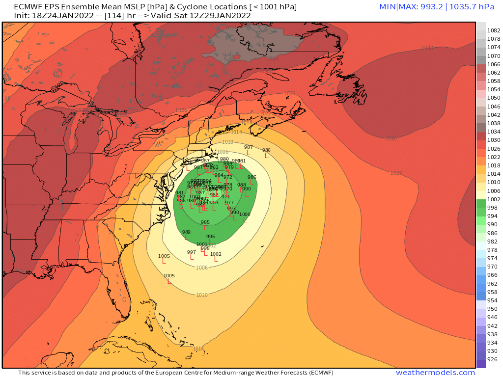
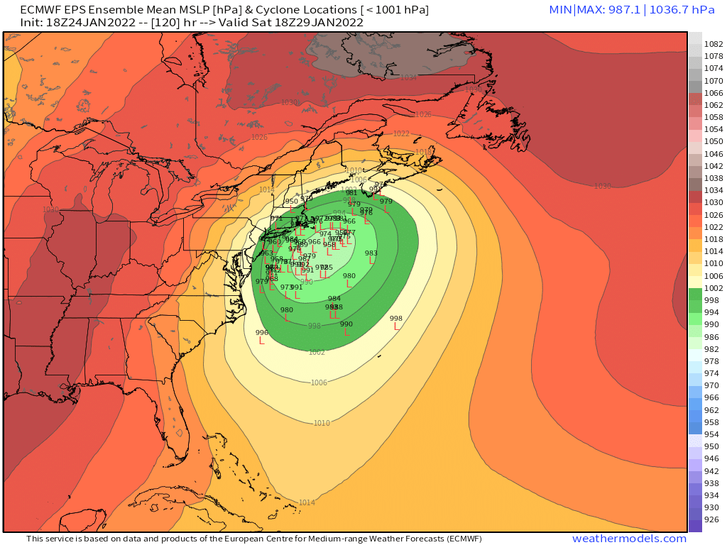
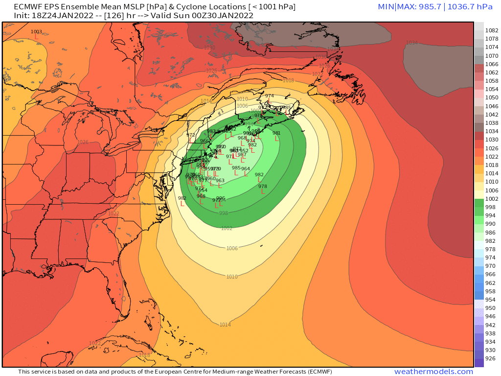
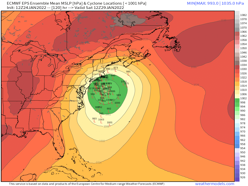
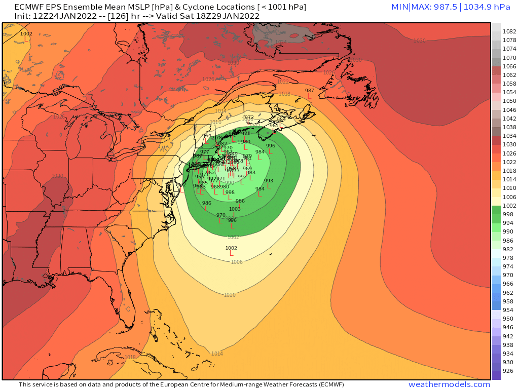
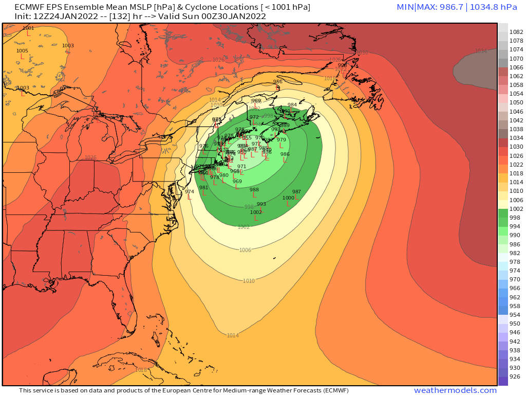
Today has really started narrowing the clusters on the ensembles and OP runs for 5 day lead time....confidence is definitely higher than normal at D5 for this one. Still have to be cautious obviously, but given the model guidance and also the larger scale pattern that is driving this evolution, we can afford to be a little more confident. It's not like some shortwave coming in slightly stronger or weaker is going to drastically change the solution....because its the larger scale features that are driving this the most.
-
Hell, if only it was Wednesday....once we get inside 72h, the shifts will not be very big.
-
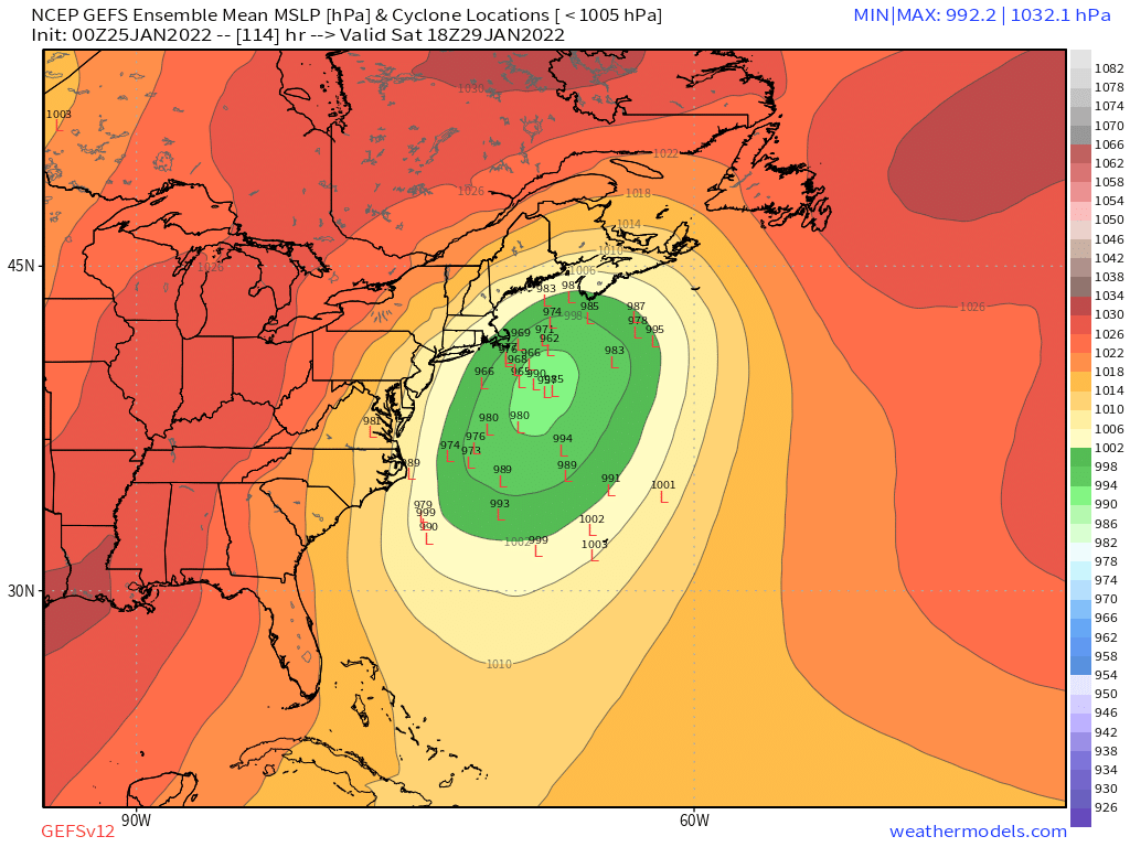
EPS mean QPF pretty good for a lot of folks
-
That was the best run so far IMHO....the densest cluster is clearly close to the mean center (BM and just E of the cape) and very few actually go inland.