ORH_wxman
-
Posts
93,092 -
Joined
-
Last visited
Content Type
Profiles
Blogs
Forums
American Weather
Media Demo
Store
Gallery
Everything posted by ORH_wxman
-
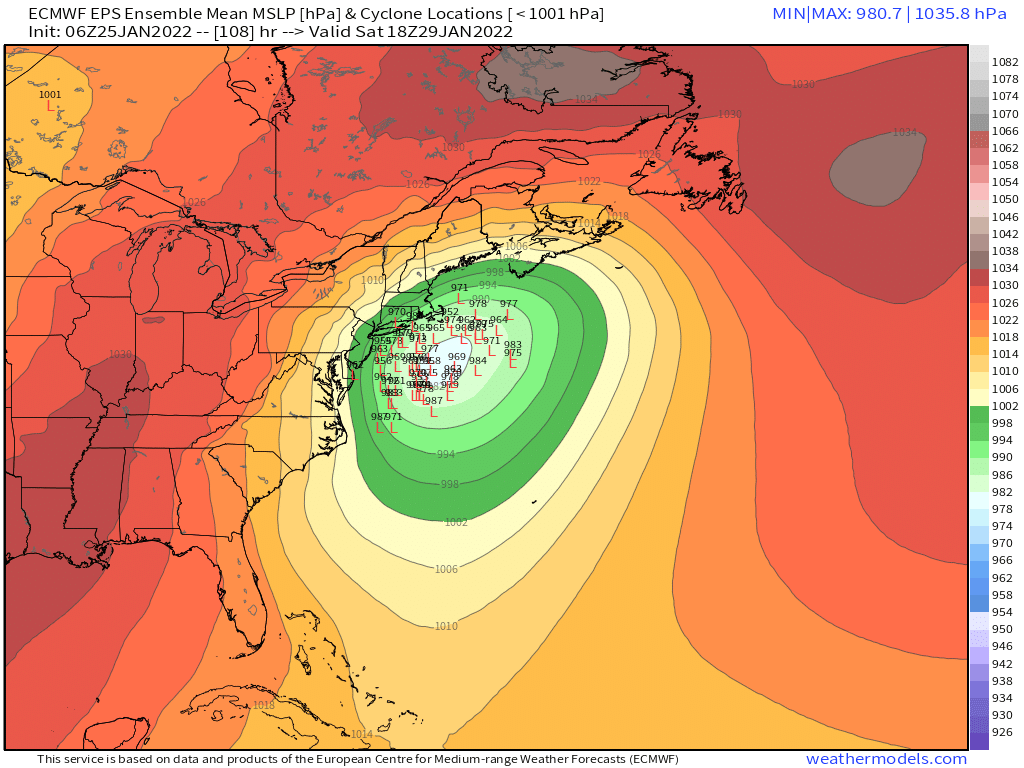
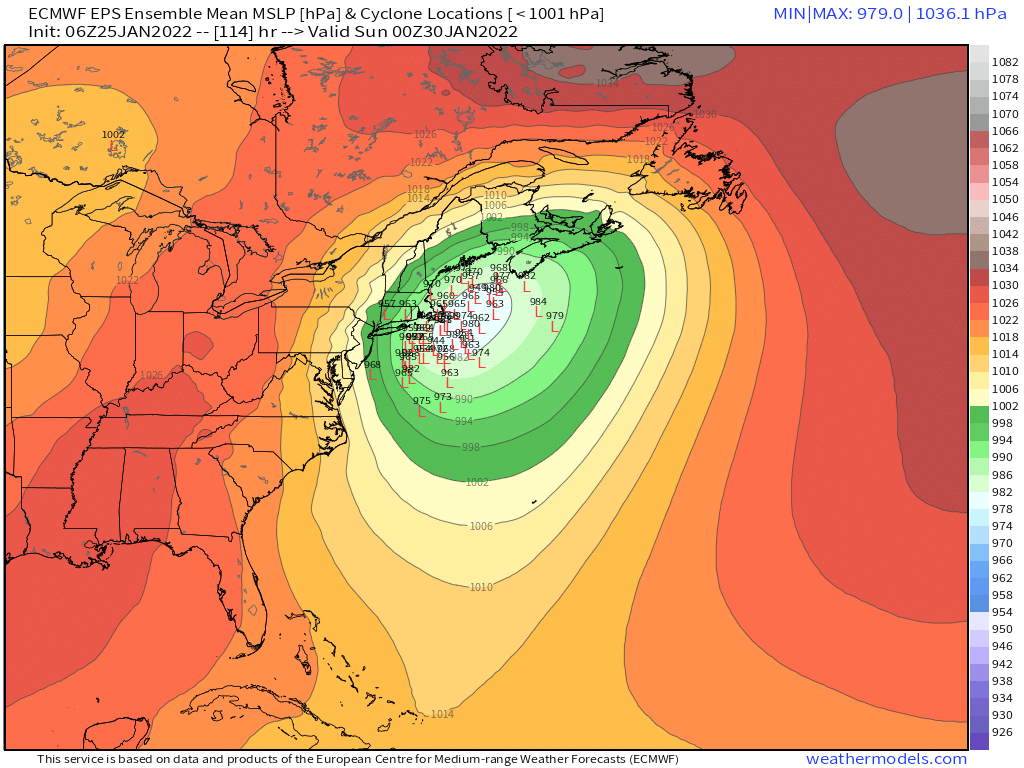
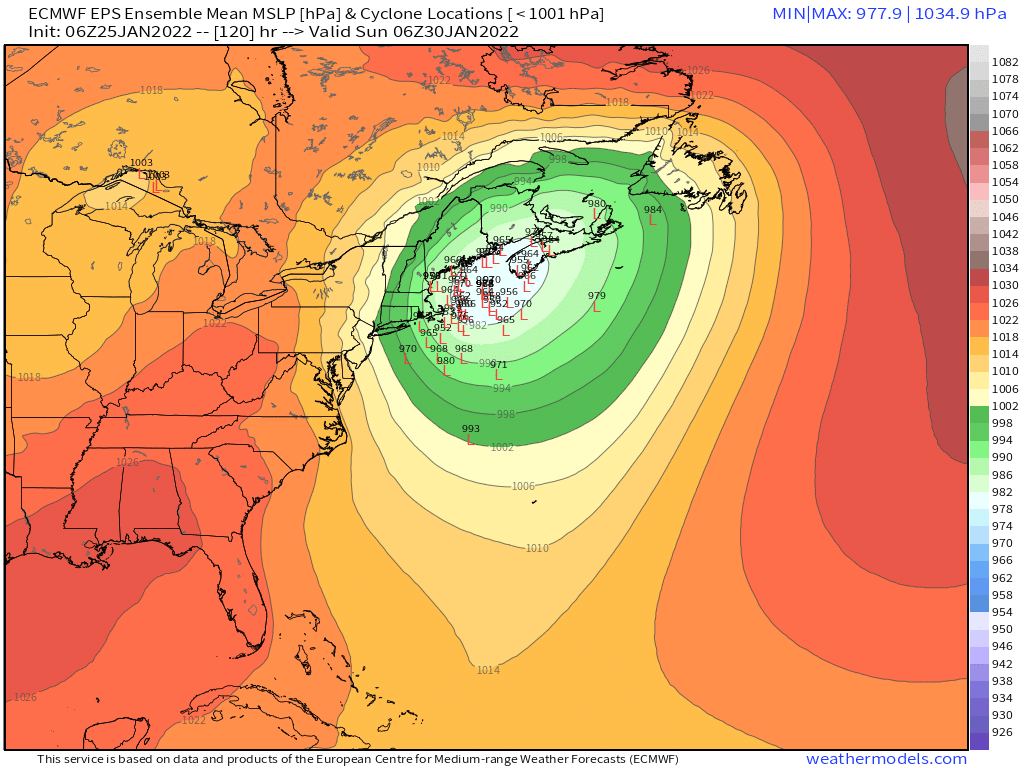
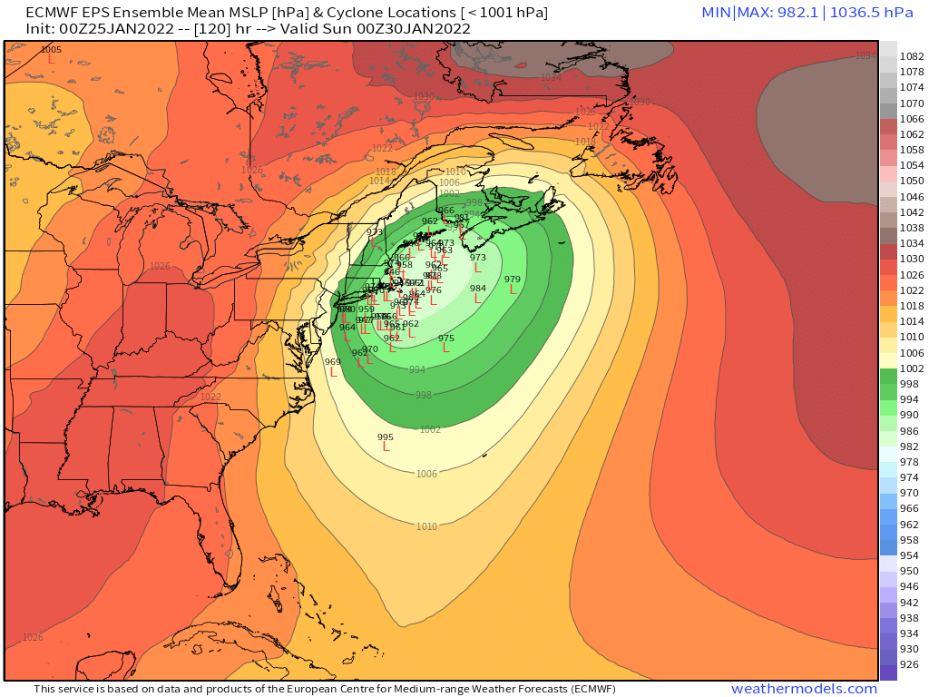
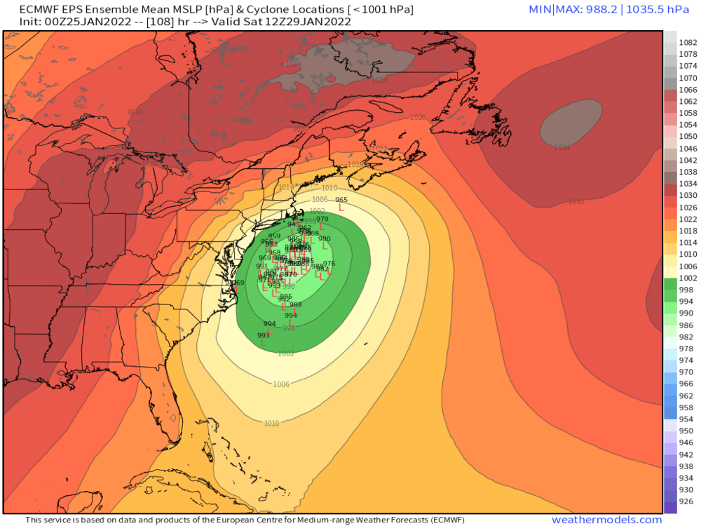
Heights have been coming in lower over Nova Scotia on these runs too. That's where that "pinching" of the north side of the trough is probably coming from...or at least related to it.
-
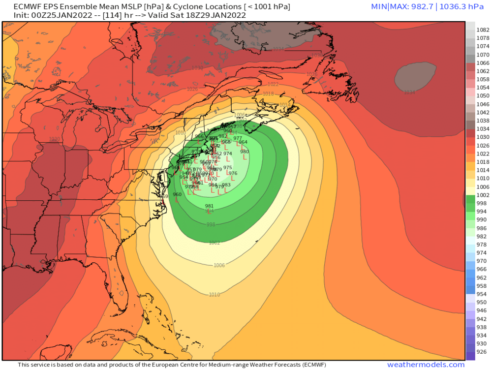
Yeah this will be more subdued than 00z....not surprising though considering how amped that run was compared to other guidance.
-
You want the GFS...later nuke job and doesn't send a dryslot near us. Maybe tickles the Cape and then collapses east.
-
Yeah there would actually be a secondary band on the outer part of the precip shield on that solution...there's a decent area of ML fronto out in W MA and W CT and along the NY border. It wouldn't be a death band like back east, but it would probably drop a nice fluffy secondary jack.
-
Yeah technically you're right, but we've coopted the term over the years to mean a historical storm wherever it hits. Like we'll say "that's a HECS for Portland Maine"....kind of doesn't really make sense when you break down the acronym, but it's still easier than typing out "a historic storm for PWM"
-
Lol, 952 over the BM on the GGEM. That's the kind of stuff I used to draw in my notebook in college during class when I was bored.
-
That capture is how you get a HECS....you need it to stall for 6-8 hours...almost all the great ones did it at least that long. Couple rare exceptions maybe....Feb 5, 2001 for interior.
-
Northern side of the trough is getting pinched a bit...the RGEM was doing that too which is why I told Ray it would be east of the Euro despite phasing in most of the southern stream....that northern pinch is something to watch.
-
This is gonna be a mushroom cloud somewhere south of the islands.
-
It would be a phased tempest but the trough axis is solidly east of the 00z euro on the RGEM.
-
NAM would prob be more than a light event....it is more amped than the 06z GFS was at 90h.
-
Yeah I was expecting it better too. My guess is the EPS is too amped, but it is closer to reality than the GEFS. Maybe the old 70/30 rule will restore sanity to the wx forecasting world. But knowing this year...prob not.
-
Yeah we'll see...the classic 70/30 compromise used to work very well...we will see if that happens this time.
-
Clusters on the 06z EPS weren't too different from 00z...the furthest west members got erased, so that's prob why the mean ticked a shade east but the overall clusters really didn't change. Funny how this is playing out very similarly to Jan 2015....Euro and its ensembles are the furthest west while other guidance is further east. Before the central/western CT peeps get triggered...it doesn't mean it's going to play out just like that storm did.
-
EPS has two clusters. One near the BM and another to the west probably kind of like the Op
-
It would actually be kind of funny if after all this, a bunch of people got 6” of sand because of dryslotting. But yeah, don’t want any part of that look.
-
Yes. Or have H5 tighten up a little bit so that we’re getting firehosed with heavy precip even if the ML deformation is off to our west…kind of like a Jan 2011 or Feb 2013….you don’t get those nasty dryslots hitting us even though deformation bands are west.
-
That run was definitely very eerily similar to Boxing Day in the evolution. Right up to the 500mb dryslot too. Boxing Day slotted so bad because not only did it close off and capture far SW, it was really broad at H5 and tore the dryslot all the way up into SNE. We can sometimes get away with systems getting captured way SW (see Dec 92), but you don’t want this big northward broad push aloft that shoves the dryslot really far.
-
Yeah I’m not that worried about stuff like that yet. It’s always an outside possibility but my guess is it looks different as we get closer.
-
Boxing Day tracked over the cape and kept the Cf pinned near south shore. This run is similar with the type of CF being pinned pretty far south toward the low center.
-
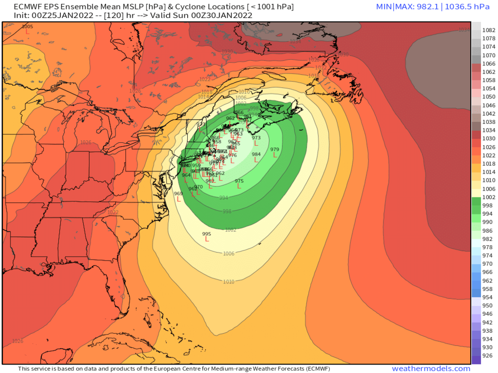
Def coming west of 12z for sure. Even though 18z didn’t go out far enough, it looks more amped than that run too.
-
They reprogrammed me. Now I’m talking to copying machines like Albert Pujols in that old sportcenter commercial.