ORH_wxman
-
Posts
93,092 -
Joined
-
Last visited
Content Type
Profiles
Blogs
Forums
American Weather
Media Demo
Store
Gallery
Everything posted by ORH_wxman
-
Prob October 30th of last winter or 12/5/20 also. Had almost 10” on winter hill in the latter event…both started as rain.
-
Too bad we can;t lock that run in...that would be pretty good for a lot of the forum...NNE gets a nice chunk and SNE gets the goods later in the system and nobody torches really except maybe the south coast really early on.
-
Usually im ok on the phone, but not as good as when I'm sitting at the computer. But this is probably not a good system for me to do in-progress model comparison on the phone because of how many parts are moving on this one....like i can notice out west looks more suppressed but then the cold press up in Ontario/Quebec is a little less and that can cause conflicting signals. When I can toggle properly, it's a lot easier to see the whole map differences.
-
Jan 1987 was good....1986 was utter trash. Jan 1988 was ok, maybe slightly above normal snow and quite cold.
-
Nice CJ for scooter and south shore from 102-114.
-
You weren't forecasting a Feb 7-9, 2015 redux with 2 feet at BOS?
-
Yeah this is pretty close to 12z which is part of the reason it’s hard to do this on my phone. I think it’s prob a smidge warmer looking back toward PA/OH. Still going to be a cold solution though in comparison to other guidance.
-
Lol now it looks a little colder at 66. I’m done trying to do this on my phone. I’ll have to cancel myself for 18z run analysis when I’m off my computer.
-
I take that back…was toggling the wrong frames. It’s a bit warmer.
-
GFS actually looks colder through 54h.
-
There will be ice, just a relatively narrow zone that gets more than transitional ice. In scenarios where this gets pressed more, most locations would see ice during the transition to snow but only a small area will see prolonged icing. Anyways, we have another couple cycles to figure out where this is honing in on. Trends today were pretty incoherent.
-
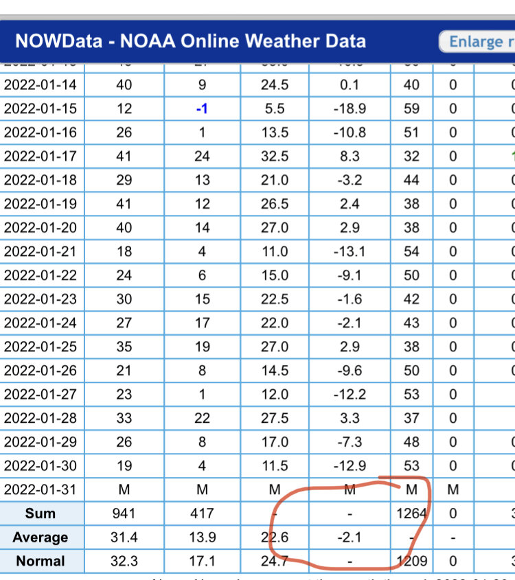
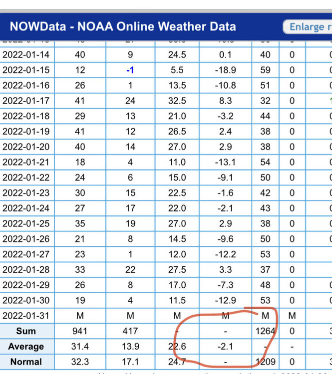
Hmmm. ORH says -2.1 right now. Are you using old normals?
-
Yeah once the NAM starts trending, it never reverses course.
-
My guess is ice zone is probably pretty narrow in this system. That said, it’s possible that narrow zone ends up over SNE. NAM might be pretty icy at least for a chunk of SNE if we extrapolated another frame….but worthless endeavor on the NAM
-
Schwoegler had thunderstorms in E MA for that one two days out before it trended way colder.
-
NAM is going to be more suppressed than 12z. Not really in range yet, but the signs are pretty clear by 48h, so it's not 100% useless on that front.
-
EPS cancels the Feb torch....what a tragic bust by the weeklies if that's right.
-
Yeah I know what he was talking about....but it doesn't really mean anything. Strong highs don't have to press more than models show them. Models could just be overdoing the high. I tend to put more stock in the high strength and magnitude of cold when it's already established over us. Once they get established, they are VERY hard to move. IF this one can get established out in front, then its not going to be rain....but we obviously don't know if it gets established or not.
-
No he's saying the base of the mountain had 2" for the month (while 8k higher up had 6")....he wasn't talking about the depth (base) of the slopes.
-
Yeah but press where? Yeah, it might might press more, but it does it press BEHIND the storm and not in front of it?
-
Again, the high strength itself isn't the question....it's the orientation of it...does it press down to the east prior to the wave gaining latitude? The Euro says not enough outside of NNE. It might be too amped, but don't make the mistake of just citing the high strength...it doesn't mean much if it's not established over our region prior to the storm. If that high was sitting up over Quebec City prior to the storm, then I'd say it matters way more.
-
Euro has been over-amped all year. Could easily slide south some.
-
The problem is the high is a beast, but the storm makes it here before the high presses in...so the high could be 1060mb and it wouldn't matter. The key is getting that high to press down prior to the storm arriving.
-
Looks more amped at 54h than 06z. Though the southern stream hanging back in the southwest looks weaker...so it could change in the next few panels.
-
If you had to pick a clunker month out there, a warmish January after a record-breaking December would be the way to do it....you can enjoy the obscene base depths without having to bundle up. Kind of like skiing on corn up here in late March after an epic month or two.