

ORH_wxman
-
Posts
93,092 -
Joined
-
Last visited
Content Type
Profiles
Blogs
Forums
American Weather
Media Demo
Store
Gallery
Everything posted by ORH_wxman
-
3rd year Ninas are pretty rare. But within that small sample, every December has been cold Dec 1910 Dec 1975 Dec 2000 Dec '56 and '85 barely miss the cut due to them being borderline cold neutral cases, and Dec 1945 barely misses because the prior year was borderline cold-neutral sandwiched between 2 Ninas. 1956 was actually just barely below avg so you can classify it as average temps. But there is a notable lack of warmth in all those years for December. So I think our chances for a colder December are increased this season from the baseline. Most of those winters went out with a relative whimper though with a huge exception of 2000-2001.
-
Update: As of 8/13, the NSIDC SIA was 4.07 million sq km. Here’s how other post-2007 years compare on the same date: 2021: -240k 2020: -960k 2019: -850k 2018: +100k 2017: -340k 2016: -470k 2015: -490k 2014: +480k 2013: +190k 2012: -1.04 million (-1040k) 2011: -650k 2010: +80k 2009: +250k 2008: -350k 2007: -690k
-
Update: On 8/10, the NSIDC SIA was 4.25 million sq km. Here's how other post-2007 years compared on the same date: 2021: -350k 2020: -850k 2019: -830k 2018: -190k 2017: -380k 2016: -590k 2015: -560k 2014: +420k 2013: +80k 2012: -1.16 million (-1160k) 2011: -690k 2010: -60k 2009: +220k 2008: -290k 2007: -600k
-
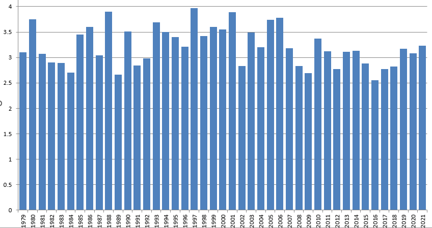
Here's the post-2007 NSIDC area minimums: 2007 2.954993 2008 3.079552 2009 3.547109 2010 3.072129 2011 2.916451 2012 2.228429 2013 3.607877 2014 3.576643 2015 3.139137 2016 2.463209 2017 3.000742 2018 3.235357 2019 2.871403 2020 2.5859 2021 3.1658
-
It makes sense that we're coming back to the pack a little bit since the mean minimum area since 2007 has been 3.03 million sq km (median 3.07 million sqkm)....and we've only had 3 seasons above 3.5 million sq km since 2007....those being 2009, 2013, and 2014. In fact, those are the only 3 post-2007 seasons with a minimum over 3.25 million sq km. The next closest was 2018 at 3.23 million sq km.
-
Update: On 8/7, NSIDC SIA was at 4.32 million sq km. Here is how other post-2007 years compared on the same date: 2021: -220k 2020: -840k 2019 -790k 2018: -10k 2017: -290k 2016: -660k 2015: -470k 2014: +380k 2013: +240k 2012: -1.14 million (-1140k) 2011: -570k 2010: -120k 2009: +200k 2008: -120k 2007: -440k
-
Update: On 7/30, NSIDC SIA was 4.91 million sq km. Here’s how other years compared on the same date to 2022: 2021: -160k 2020: -1.16 million (-1160k) 2019: -810k 2018: -220k 2017: -230k 2016: -720k 2015: -570k 2014: +170k 2013: -50k 2012: -980k 2011: -690k 2010: -470k 2009: +50k 2008: +20k 2007: -590k
-
Update: On 7/26, NSIDC SIA was 5.25 million sq km. Here’s how other post-2007 years compared on the same date: 2021: -250k 2020: -1.06 million (-1060k) 2019: -860k 2018: -350k 2017: -420k 2016: -640k 2015: -540k 2014: tied 2013: -310k 2012: -880k 2011: -690k 2010: -460k 2009: +140k 2008: +100k 2007: -710k
-
Update: NSIDC SIA was 5.40 million sq km on 7/23. Here’s where previous years since 2007 compared on the same date: 2021: -340k 2020: 1.01 million (-1010k) 2019: -840k 2018: -370k 2017: -450k 2016: -600k 2015: -400k 2014: -90k 2013: -460k 2012: -890k 2011: -800k 2010: -310k 2009: +10k 2008: +40k 2007: -640k
-
Large part of the ice pack has fresh snow cover on it from the cold cyclone last week. It's definitely help put the breaks on the area loss since the 2nd week of July.
-
Update: On 7/20, NSIDC SIA stood at 5.52 million sq km. Here's how other years stood at the same point compared to 2022: 2021: -280k 2020: -850k 2019: -880k 2018: -180k 2017: -380k 2016: -480k 2015: -290k 2014: -100k 2013: -220k 2012: -910k 2011: -590k 2010: -110k 2009: +120k 2008: +220k 2007: -500k
-
Update: On 7/16, NSIDC SIA was at 5.84 million sq km. Here’s how other years looked on the same date compared to 2022: 2021: -290k 2020: -720k 2019: -840k 2018: -50k 2017: -200k 2016: -520k 2015: -240k 2014: -60k 2013: -230k 2012: -900k 2011: -360k 2010: -270k 2009: +70k 2008: +190k 2007: -590k
-
I’m not sure how they are getting that data. Only issue I see is that graph is from NASA and not NSIDC….so maybe they are using a different algorithm. Here’s a dataset of NSIDC extent and area but it stops in late 2021…. https://docs.google.com/viewer?a=v&pid=sites&srcid=ZGVmYXVsdGRvbWFpbnxhcmN0aXNjaGVwaW5ndWlufGd4OjU1OGIwZWI0NGI2ZDI5YTM I’ve been using the below site for in-season area updates in 2022 https://cryospherecomputing.com NSIDC has the area available somewhere on their site but it’s hard to find. The top of the first link’s data source explanation might be able to get us there but I haven’t taken the time to try and build my own spreadsheet yet based off it.
-
Where are you getting the area numbers from? There hasn’t been a minimum above 4 million sqkm since 2006.
-
Bluewave’s numbers were extent while I’m posting area. Area is a little different.
-
Update: As of 7/12, NSIDC area was 6.26 million sq km. The cold cyclone over the CAB right now continues to slow the area loss. Here are where other years compared on the same date: 2021: -730k 2020: -750k 2019: -930k 2018: -190k 2017: -70k 2016: -620k 2015: -210k 2014: +30k 2013: -120k 2012: -940k 2011: -460k 2010: -330k 2009: +230k 2008: +40k 2007: -490k
-
Update: Now having data 10 days into July, we’ve seen 2022’s melt slow even further relative to the post-2007 field. On 7/10, NSIDC area stood at 6.35 million sq km. Here are where other years stood compared to 2022 on the same date: 2021: -480k 2020: -620k 2019: -820k 2018: -190k 2017: -20k 2016: -540k 2015: -90k 2014: +200k 2013: +20k 2012: -680k 2011: -280k 2010: -270k 2009: +230k 2008: +130k 2007: -350k Theres currently a deep, cold low pressure over most of the CAB right now and that is not forecasted to move much over the next 5-6 days….so I’m skeptical we play much catch-up in the next week. There are signs that it may try and drift more to the ESS/Chukchi beyond that time frame, so perhaps the melt will pick up again if that happens. But we’re wasting what’s left of the prime sun angle up there in the meantime.
-
Update: On 7/1, the NSIDC SIA sootd at 7.07 million sq km. Here's how other years compared on the same date: 2021: -70k 2020: -510k 2019: -450k 2018: +320k 2017: +10k 2016: -240k 2015: +130k 2014: +260k 2013: +340k 2012: -650k 2011: -210k 2010: -380k 2009:+640k 2008: +220k 2007: -400k For the minimum Sea ICe Area prediction, we can use prior years' melt out from July 1st onward to estimate how this tear will turn out because there hasn't been much of a trend in ice loss after 7/1....the big trend has been prior to 7/1. We have maybe seen a slight increase in melt from 7/1 since 2007, so I will weight those years more. Below is a table of how 2022 would turn out if it followed previous years' melt out from 7/1 onward.... For example, if we used 1989's ice loss from here on out, we'd finish at 2.66 million sq km. 2016 had the highest meltout beyond 7/1 on record, and would produce a final SIA min of 2.55 million sq km if we followed that path in 2022. You'll note that the record year of 2012 is only like 4th or 5th most ice loss from 7/1 onward which means most of the damage was done prior to 7/1. We can pretty much rule out a new record this season based on this data. We'd need to obliterate the post 7/1 loss record set in 2016 to achieve it. A top 3 lowest min is probably out too.....likewise, a top 3 highest min in the post-2007 context is likely out as well....though another 2010 from here on out would achieve it. All other post-2007 years would fail, however. All that said, the average ice loss from 7/1 onward in the post-2007 era is 4.09 million sq km which would produce a 2022 min of 2.98 million sq km (7.07 million minus 4.09 million). I'm going to stick very close to this number and go with a final minimum of 3 million sq km +/- 300k. I might hedge a little higher if the forecast was colder on the Beaufort/CAA side over the next week but they will continue to see mild weather so I will stick with 3 million. Final extent prediction is a lot harder than area because extent relies a lot upon compaction/dispersion which is really hard to forecast. But that said, usually something in the 3 million sq km range for area will produce an extent min on NSIDC of around 4.5-4.8 million sq km. So I will go with 4.6 million +/- 500k....I have larger error bars on the extent. (side note: JAXA extent usually comes in around 200k lower than NSIDC extent after their algorithm update post-2013....so I will not be using Jaxa to verify this prediction. Only NSIDC daily extent)
-
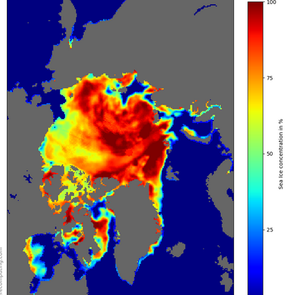
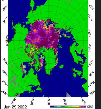
Yeah the melt-ponding has been very extensive over the Beaufort/Chukchi/CAA portion of the ice....see below. The first image is the NSIDC (SSMI/S source) one and the second is AMSR2. Note how the concentration is much higher on the AMSR2 image because it's not fooled by melt-ponding nearly as much like SSMI/S is.
-
Update: The accelerated melt ponding from the dipole has pushed 2022 more toward the higher melt years of the pack now instead of being near the high-retention years....but still not into the highest tier level like 2012. NSIDC SIA on 6/29/22 stood at 7.12 million sq km. Below are how other years compared on the same date: 2021: +40k 2020: -50k 2019: -280k 2018: +490k 2017: +310k 2016: +20k 2015: +410k 2014: +400k 2013: +560k 2012: -510k 2011: -30k 2010: -310k 2009: +910k 2008: +550k 2007: -180k I'm away the next few days but I'll have my final prediction for SIA minimum when I get back and the 6/30 and 7/1 data is in. Unless there are drastic changes over the next couple days, this year's prediction is probably going to be somewhere between a top 5 and top 10 melt year....I don't think it has quite enough juice to make a top 3 and the dipole recently has done enough damage to take a result like 2009/2013/2014/2018 out of the equation.
-
Update: The melt has picked up a bit with the dipole pattern currently in progress across the arctic basin. As of 6/22, the NSIDC SIA stood at 8.09 million sq km. Here's how other years compared on the same date: 2021: -520k 2020: -430k 2019: -390k 2018: +350k 2017: +20k 2016: -480k 2015: +30k 2014: +70k 2013: +270k 2012: -650k 2011: -140k 2010: -480k 2009: +710k 2008: +50k 2007: -460k The dipole pattern looks like it will persist for another 4 days or so and then the low currently in the ESS will migrate toward the Beaufort/CAB and produce a reverse dipole which would slow the sfc melt down again. So the time to rack up losses is right now and the next few days.
-
When I first started looking more into NSIDC SIA as a predictor around 10 years ago, I almost chose 6/20 as the cutoff date because it's not that much less accurate than 6/30....so I think most of this season is likely baked into the pie at this point. There have a been a few years (like the previously mentioned 2008) which really went crazy the final 10 days of the month to end up closer to the bigger melt seasons, but a large majority of the seasons were pretty baked by the solstice. I think the best-guess theory (with the assistance of some literature on melt ponding) is that there simply isn't enough time in the melt season to make up for a lack of melt-ponding in the first 3 weeks of June. If you fall behind in the melt-ponding during that period, you pretty much cannot catch back up unless you really have some crazy anomalous weather. Most of the melting in the 2nd half of the summer is from bottom melt rather than surface melt (sfc temps cool back below freezing pretty quickly late summer), so you need as much surface melt momentum as possible early on to achieve a big melt season...and lots of melt-ponding helps enhance sfc melt by lowering albedo and increasing heat transfer, etc.
-
Update: NSIDC SIA stood at 8.39 million sq km as of 6/20/2022. Here's where other years stand now: 2021: -580k 2020: -720k 2019 -470k 2018 +90k 2017: -50k 2016: -420k 2015: -170k 2014: -80k 2013: +60k 2012: -740k 2011: -330k 2010: -450k 2009: +710k 2008: +70k 2007: -610k You can see there's some pretty clear divergence now between the huge melt years and the higher retention years. There's still some time for movement (2008 lost a lot in the final 10 days of June), but 2022 is quickly trending toward years like 2018/2017/2014/2013. There is a dipole pattern setting up over the next week or so....if 2022 is going to make a move toward the big dog melt years, it has to be during this next week.
-
Update.... NSIDC SIA stood at 8.65 million sq km as of 6/16 How other years compared to 2022 on this date: 2021: -320k 2020: -410k 2019: -520k 2018: +50k 2017: +120k 2016: -330k 2015: -70k 2014: +150k 2013: +110k 2012: -800k 2011: -330k 2010: -190k 2009: +670k 2008: +180k 2007: -170k
-
Update (NSIDC SIA stands at 8.72 milion sq km as of 6/15): 2021: -90k 2020: -220k 2019: -460k 2018: +140k 2017: +110k 2016: -280k 2015: -50k 2014: +80k 2013: +190k 2012: -730k 2011: -200k 2010: -210k 2009: +660k 2008: +210k 2007: -140k 2022 is starting to fall behind the pace of loss on the top melt years like 2012, 2016, 2020, 2011, 2007, etc. Gonna need it to pick up quite a bit over the next 2 weeks to have a shot at a new record or even top 3. I think there's probably too much ice in the Beaufort/Canadian Basin/CAA this year for a huge season.

