ORH_wxman
-
Posts
93,092 -
Joined
-
Last visited
Content Type
Profiles
Blogs
Forums
American Weather
Media Demo
Store
Gallery
Everything posted by ORH_wxman
-
I think you’d be surprised how bad NNE did in the 1980s too. Esp the latter half. Lot of stein up there. Early 80s we’re great there.
-
Yeah it was just after lunch. Prob between 1-2pm. IIRC ORH went from nothing to heavy snow inside 30 min and it stayed heavy snow on official ASOS for like 10-12 hours straight. Just a massive 10-12 hour crush job and then it was over. There wasn’t a ton of snow between that storm and the Mar 4-6, 2001 storm…but it mostly stayed OTG. Then March went gangbusters.
-
‘81-82 was an excellent winter…one of the few good ones that decade. Very cold that winter with a lot of good events culminating in the April ‘82 blizzard. The problem with the 1980s is they had so few blockbuster storms…esp post-1984. We have a few biggies in 1987 (esp interior) but that’s about it. Then you mix in some absolute garbage snow winters overall like ‘84-85, ‘85-86, ‘88-89 and the decade averages out quite poor.
-
Feb 5, 2001 was an incredible storm for its intense snowfall rates. Almost all of that fell in under 12 hours.
-
The 1980s are pretty cold on that graph. The defining feature is really no huge torches of any kind outside of the super Nino ‘82-83 winter. So while they didn’t have utterly frigid winters post-82, they consistently were below normal on temps.
-
Despite the 16th being useless, there definitely seems to be a pretty active look going forward. We may play with fire, but lots of chances and lots of cold lurking north next week and beyond.
-
North Shore sometimes gets hot and it just snows there. Happened a lot in the 2013-14 winter. They had it coming after the recent brutal stretch there.
-
If we somehow reel this system back in to be a warning event in SNE, this winter will really start moving up the charts. It’s already been a damned good winter but we have a lot of snow climo left and you don’t want to waste those periods.
-
This still feels like classic bait…but Euro skynet suite showing some enthusiasm makes this a little more interesting. Still need other guidance to jump on board.
-
Sort of, but not in the way i meant it....it was frigid in 2015 but we stopped getting good snow events and the south coast and mid-atlantic actually got some in late Feb and March. But yeah, 2015 couldve been put into even further epic territory if we had scored anotehr big dog in March that year. I really meant years where it just basically melts off slowly in 40F weather with no reinforcements of significance.
-
It does almost every year....the question is are we going to keep the continuous winter train going or is the ride mostly over and then we're just mixing in stat padders in March/April. Could go either way....some years like this died a slow death in late Feb/early Mar (like 2011)....while others went gangbusters (2001)....some gave us faux spring and then went gangbusters back to winter afterward (2017 and 2018 both did this)
-
The question is if we can continue this slow pack build up or if we start getting some rainers mixed in.....I do think we'll definitely see additional snow events. But if we pseudo-cutter next week and have these seasonably milder days mixed in, then you start melting back the icy grip winter has had on us....whereas if we only do a little bit of maintenance melting, and then smash an arctic high in front of next week's system and turn into a beefy cold SWFE, then it feels like winter is still in full swing....two somewhat different paths that we aren't sure on yet.
-
Pretty much all guidance has something late next week. It’s just a question of whether we press a high down ahead of it for a winter event or if it’s a cutter or pseudo-cutter.
-
EPS wasn’t nearly as warm as OP in LR. Still pretty snowy in the 11-15 day.
-
GFS and euro flip flopped in the long range today.
-
Feb 10-11 Mid Week Minor Event - Ride the hot hand?
ORH_wxman replied to HoarfrostHubb's topic in New England
Yeah this beats any 2018 stretch. The late Dec 2017/first 10 days of Jan 2018 was pretty awesome but didn’t have the pack this deep. March 2018 was pretty damned epic but it was a slow melt given time of year. Feb 2021 was a really nice stretch to your west but it doesn’t beat this. Def have to go back to 2015 to get a stretch this long with pack this deep and some decent cold to go with it. -
Another north shore jack would be fitting too
-
Congrats
-
Yeah but it’s all blocked up. GFS def trending toward the Euro idea of blockier look.
-
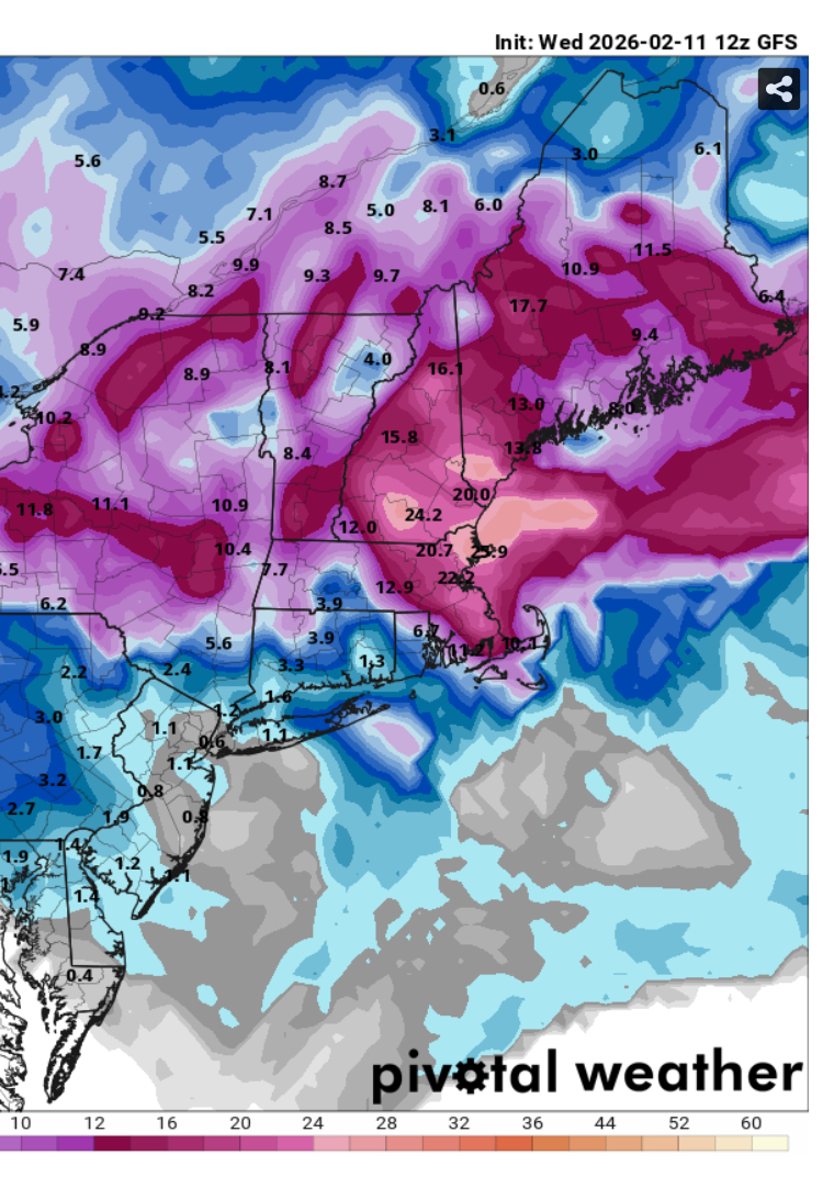
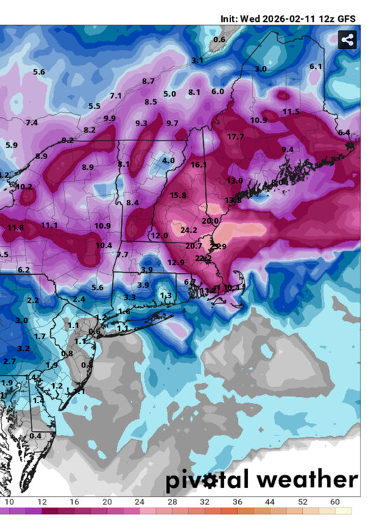
GFS try to pull a mini-Feb ‘69 next Friday.
-
GFS skynet still way SE...not particularly close.
-
Downslope dandy today....might tickle 40.
-
Euro skynet was much closer but still a whiff. At least it was finally even half-interested. Well need a pretty solid move by all other guidance at 12z I think.
-
Feb 10-11 Mid Week Minor Event - Ride the hot hand?
ORH_wxman replied to HoarfrostHubb's topic in New England
It’s interesting that we had good snow growth during the heaviest rates last night but in between it was kind of grainy. The snow overall felt a little dense shoveling this morning. Looks nice though. 1.6” storm total with a tenth new after 1.5 last night before going to bed. -
Feb 10-11 Mid Week Minor Event - Ride the hot hand?
ORH_wxman replied to HoarfrostHubb's topic in New England
North shore jacked again for SNE.