baltosquid
-
Posts
1,236 -
Joined
-
Last visited
Content Type
Profiles
Blogs
Forums
American Weather
Media Demo
Store
Gallery
Everything posted by baltosquid
-
love seeing most members west of the mean. edit: removed image since I was ninja’d anyway
-
Honestly if the GFS comes back west at 18z I’d chalk it up to noise. If it suddenly becomes the least snowy model though and THEN its original idea of a beltway bomb comes to fruition, that would be hysterical.
-
Pivotal needs to hurry up. I want to see where these lows go
-
You’ve done an excellent job, way better than me imo.
-
Wait holy shit, the next frame is even better

-
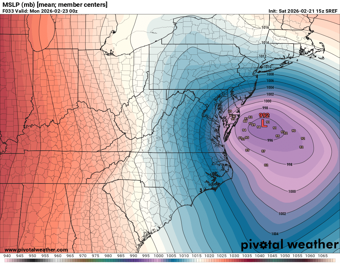
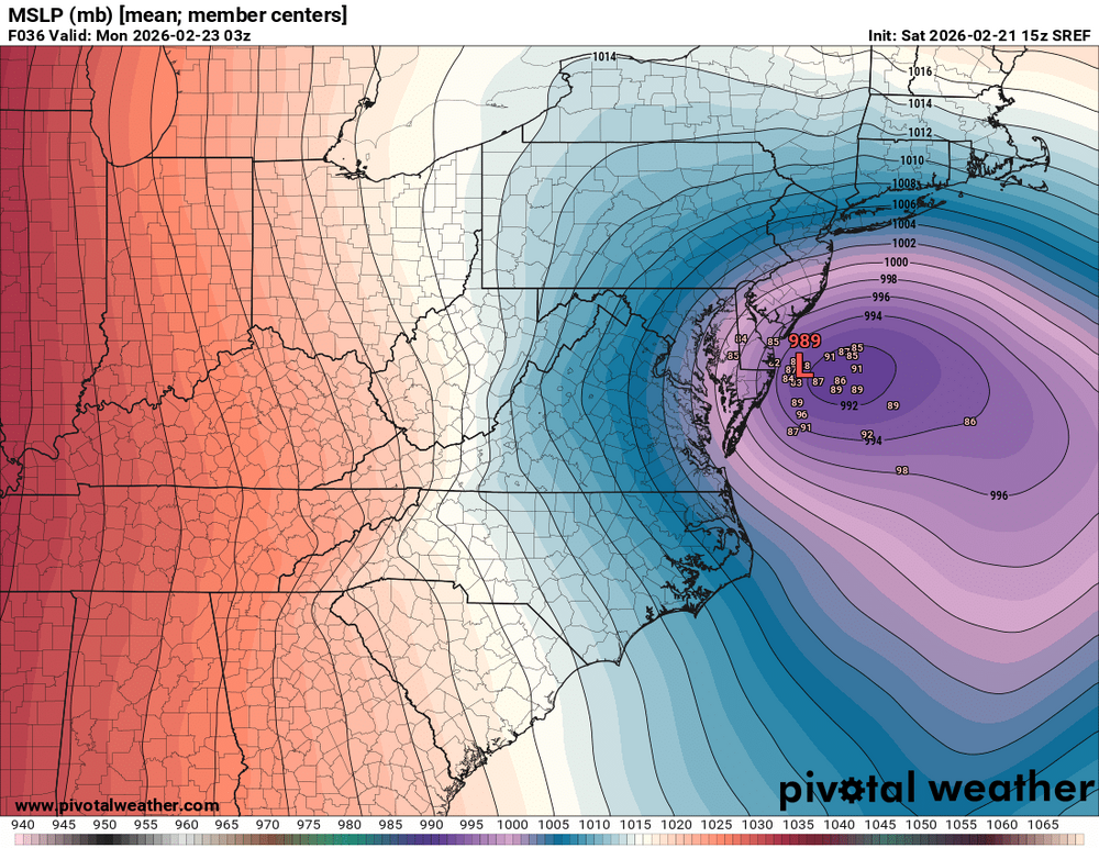
Every dog has its day as they say! Also while the mood is relatively good, why not look over at the 15z SREF… Tuck city.
-
Also I am encouraged it wasn’t one run to get to this. After the air went out of things at 00z, it started this move at 06z then accelerated it at 12z. Hopefully it’s just picking up on a final, persistent trend now and not a windshield wiper…
-
Weenie handbook subsection C article 14.7.2. “The best banding sets up NW of modeling”
-
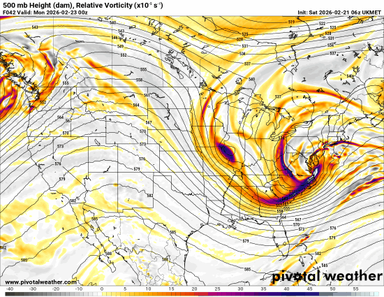
That was easily the best h5 the euro has given for this. Not a small adjustment. And check the layers - pretty stacked through 700 a few dozen miles offshore. Wow. …can we get one more?
-
Tick deeper h5 and maybe a tick negative or the same. Surface low is pretty much the same.
-
I think one could argue the h5 is a tick better on the UKMET. I think the soundings are better than the pivotal ptype suggests. Metros seem to be at 33F under heavy rates, feel like that would accumulate. Verbatim wetter for both metros.
-
-
Was weaker on the NAM. Deepens to 288 on the GFS but only 291 on the NAM. This is at hour 27. edit: terminology mixup, I mean there’s a 288 line on GFS and only 291 on the NAM, so the GFS is deeper
-
Yeah 700mb closed low is up in MI now. I should clarify it is a problem earlier. We still do close but the best runs had it happen more SW.
-
Western ridge is nice but a broader trough is blunting the heights to the east. The lakes low feature is getting more prominent. Don’t like seeing that trend stronger so late in the game. Check 700 and 850 heights. We’re not closing off there because of that and it’s taking away the heavy GFS precip. And preventing tilt.
-
GFS is running. Looks more positively tilted.
-
ICON-EPS reflects the op - tick west initially but pushes the low out faster. Minimizes CCB time west of the bay and QPF dips as a result.
-
ICON is a hold. It looks like it comes a tiny bit west initially but pushes the low east a tick quicker next frame. Totals are basically the same but verbatim the tiniest tick better. Still not gonna do it west of the bay.
-
3k does have a classic 95 subsidence area though lol. But this is a good run.
-
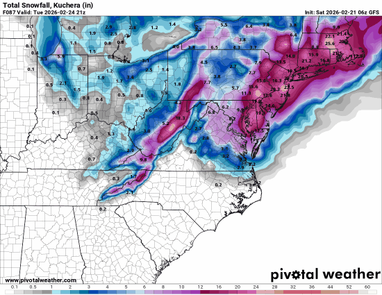
3k is dumping, wow.
-
Center of the h5 low is more southwest than both 06z and 00z. Not by a ton but it doesn’t take much to get us a better result.
-
H5 looks like it is much more like 00z again. Surface reflects that and is closer to that result through 30.
-
Man I wish it wasn’t a total fantasy. Would actually be quite the forum pleaser. CCB gets decently west and the inverted trough covers people well outside the CCB.
-
It’s wrong biased
-
Absolutely, that’s why I highlighted the 18hr look because past that’s truly beyond the pale for the HRRR lol, and is already shaky. I will take the better result but yeah doesn’t really move things