

baltosquid
-
Posts
1,236 -
Joined
-
Last visited
Content Type
Profiles
Blogs
Forums
American Weather
Media Demo
Store
Gallery
Everything posted by baltosquid
-

Feb 22nd/23rd "There's no way..." Obs Thread
baltosquid replied to Maestrobjwa's topic in Mid Atlantic
All wet snow now pretty much -
Feb 22nd/23rd "There's no way..." Obs Thread
baltosquid replied to Maestrobjwa's topic in Mid Atlantic
Changing over now. No longer even need to squint or even wear my glasses to see the flakes. Still mostly rain but getting quieter as flakes pick up. Next milestone, stickage... -
Feb 22nd/23rd "There's no way..." Obs Thread
baltosquid replied to Maestrobjwa's topic in Mid Atlantic
Just squinted out the window for a while. 99.99999% rain, but... a couple big flakes falling slower caught my eye. Changeover appears to be coming. -
Feb 22nd/23rd "There's no way..." Obs Thread
baltosquid replied to Maestrobjwa's topic in Mid Atlantic
Baltimore city, says 35.4 now. Dropping quick. -
Feb 22nd/23rd "There's no way..." Obs Thread
baltosquid replied to Maestrobjwa's topic in Mid Atlantic
Mesonet seems to have Baltimore dropping 1 degree over the past half hour. Took an hour and a half to drop the degree before that. Accelerating. Their site is definitely a bit cooler than Canton but hopefully this is the beginning of the crash and then snowflakes soon... I think I see the mixing line over the bay on correlation coefficient, inching NW. -
Feb 22nd/23rd "There's no way..." Obs Thread
baltosquid replied to Maestrobjwa's topic in Mid Atlantic
Rain is heavier now in Baltimore. Maybe if we can stay under these returns for a bit we can changeover somewhat on schedule. But I am basically expecting 2-4 inches. I think we've lost warning criteria potential with how warm it has gotten, barring a perfect overnight death band. Oh well. I think it can still look quite pretty tomorrow though, as long as we don't completely get minimized between the CCB and the norlun... -
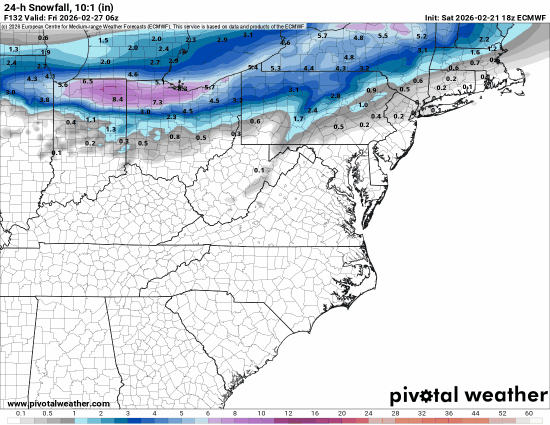
Not enthused by this as I feel like it's a situation where it coming south means potentially making it go away entirely tbh. But snow within 5 days on the euro I guess deserves a little attention.
-
FWIW temps on the EPS look good in that window and there is decent snow depth in the mean for this range (depth because I use free pivotal). Curious to see how it looks in a couple hours when we get the ensembles for 12z.
-
Feb 22nd/23rd "There's no way..." Obs Thread
baltosquid replied to Maestrobjwa's topic in Mid Atlantic
Sicko to post this gif I know but inching closer per HRRR.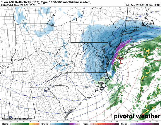
-
Whatever the next shot is, let’s hope it’s not a coastal lol. Waiting for bands to get thrown back is way more stressful than just watching the shield blossom in the TN valley.
-
Feb 22nd/23rd "There's no way..." Obs Thread
baltosquid replied to Maestrobjwa's topic in Mid Atlantic
I never disputed anything. I’m observing the poor returns that don’t correlate with temperatures dropping. It’s nowcasting time and the nowcast has light rates. -
Feb 22nd/23rd "There's no way..." Obs Thread
baltosquid replied to Maestrobjwa's topic in Mid Atlantic
Seeing the lighter returns just to Baltimore’s immediate south doesn’t inspire confidence; some wunder stations are starting to drop now but a break might undo that Not hard to see how we bust really low here. Hoping for a death band somewhere in there… -
Feb 22nd/23rd "There's no way..." Obs Thread
baltosquid replied to Maestrobjwa's topic in Mid Atlantic
That’s interesting. Definitely more NAM like if you switch over within an hour or two. Hopefully this set of heavier returns is backed up by something so you don’t warm back up! -
Feb 22nd/23rd "There's no way..." Obs Thread
baltosquid replied to Maestrobjwa's topic in Mid Atlantic
Looking over at DC/Nova wunder stations and it’s impressive how those heavy returns are bringing down the temps. Hopefully we have the same thing in store for Baltimore soon. The rain is getting louder. -
Feb 22nd/23rd "There's no way..." Obs Thread
baltosquid replied to Maestrobjwa's topic in Mid Atlantic
That backend snow is nice. If I could lock in something plausible, give me warning level up front then some snow globe stuff in daytime for a couple inches. That is the ideal outcome. But I am a little nervous about that not delivering; feels like it often doesn’t. -
Feb 22nd/23rd "There's no way..." Obs Thread
baltosquid replied to Maestrobjwa's topic in Mid Atlantic
HRRR looks either east or drier to me tbh -
Not counting on them to be right but like the data point that mesos have room to go bigger. Better to have it snowy than not...
-
SREF mean moving west again lol... money frame was hr39 at 12z. Need the next frame at 18z to compare.
-
Also while the euro AI did not move west really, its ensembles did tick west and a few members get pretty close to Delmarva
-
Hard to see but there's a member tucked right onto Cape Charles
-
Great trend to have this close to start time.
-
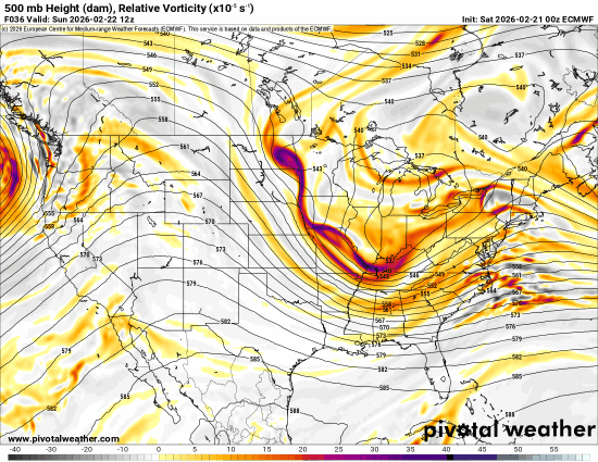
I'm behind on pivotal but in addition to better heights on either end, the euro is de-emphasizing the trailing vort (the one in the midwest, not the first one) at 24hrs. That probably helps!
-
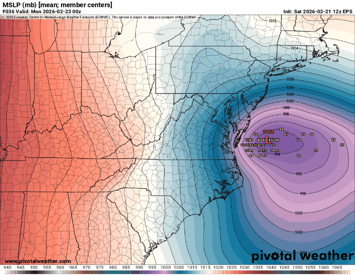
I think he means the control (same conditions as op?) is on the eastern envelope of the members. Not the op itself. But since they are initialized the same it suggests maybe the operational initialization is not quite representative of what's happening, even if the op at higher res responds better and goes further west. Does someone smarter know if this makes sense? There is a "control" right?
-
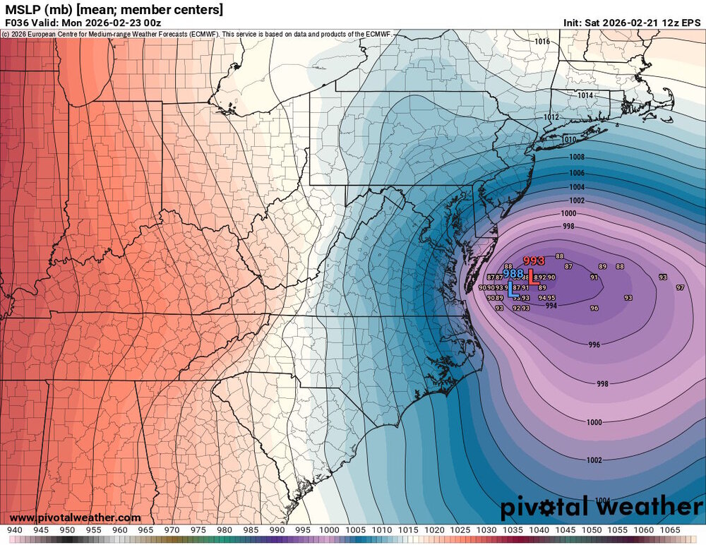
I always wish mean member plots would also put the op low. So here's my edit of that for the euro. Op in blue* (edited in case of colorblindess)
-
While it's basically the same or a little better, I think the main thing I like is the GFS didn't go more positive again. Hopefully trends more neg tilt once more; would bring back more a more aggressive capture look.


