Weather Will
-
Posts
7,315 -
Joined
-
Last visited
Content Type
Profiles
Blogs
Forums
American Weather
Media Demo
Store
Gallery
Everything posted by Weather Will
-
Feb 22nd/23rd "There's no way..." Obs Thread
Weather Will replied to Maestrobjwa's topic in Mid Atlantic
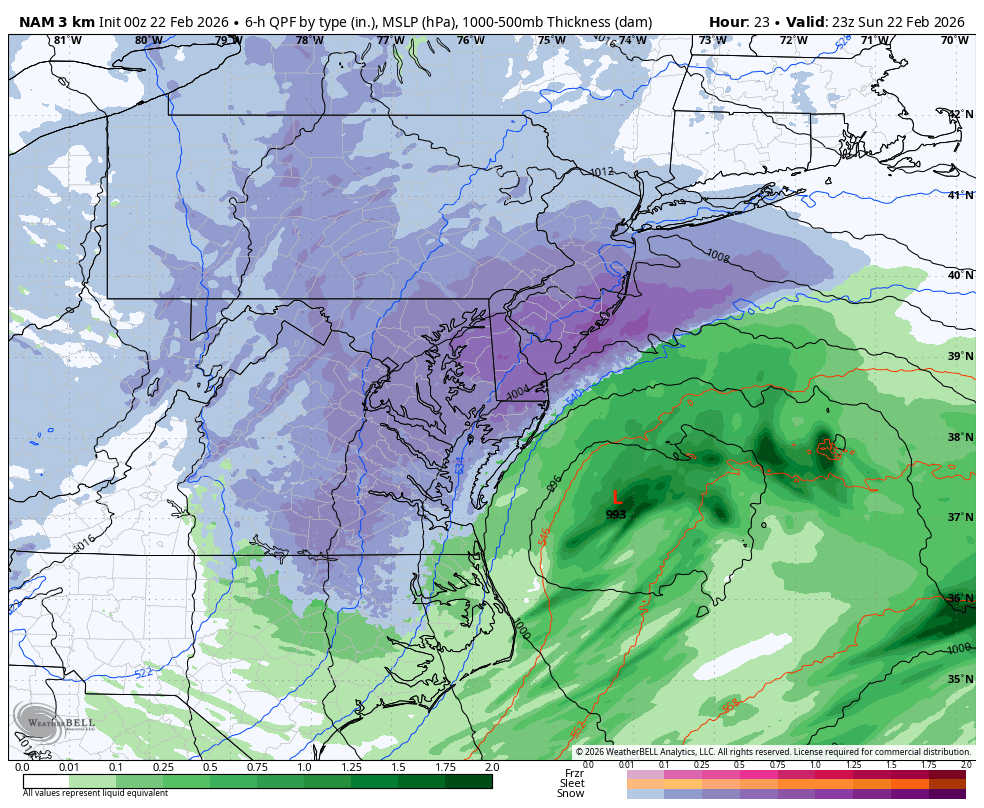
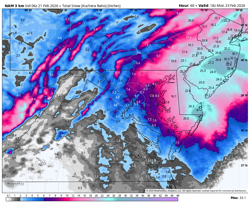
WB 3K NAM 10pm.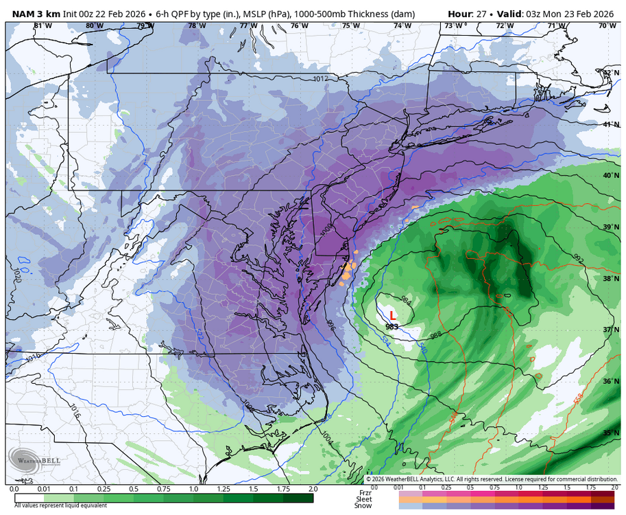
-
Feb 22nd/23rd "There's no way..." Obs Thread
Weather Will replied to Maestrobjwa's topic in Mid Atlantic
WB 3K NAM transitions to steadier snow by 6pm.
-
Feb 22nd/23rd "There's no way..." Obs Thread
Weather Will replied to Maestrobjwa's topic in Mid Atlantic
12K is crap model. 3K not nearly as good during the day. -
Feb 22nd/23rd "There's no way..." Obs Thread
Weather Will replied to Maestrobjwa's topic in Mid Atlantic
Busy day and getting caught up. Lot of talk about the low hugging the coast or going west. My non expert observation is that the reason we don't get slammed further west/ south is because the low intensifies parallel to the Delmarva rather than further south say off of Norfolk. If the storm intensifies faster than forecast and hugs the coast then the NW burbs could get heavier snow. Also, can someone better explain the IVT? I still don't get it. Thanks. -
2/22-23 "There's no way..." Storm Part 2
Weather Will replied to Maestrobjwa's topic in Mid Atlantic
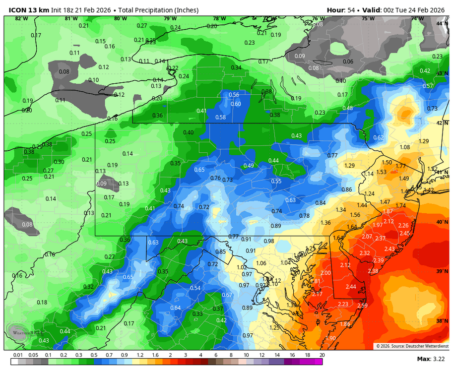
WB 18Z ICON ticked west.
-
2/22-23 "There's no way..." Storm Part 2
Weather Will replied to Maestrobjwa's topic in Mid Atlantic
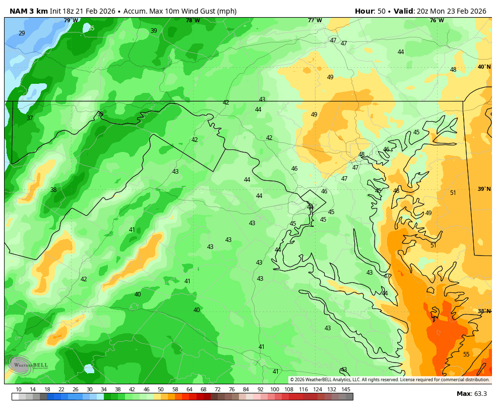
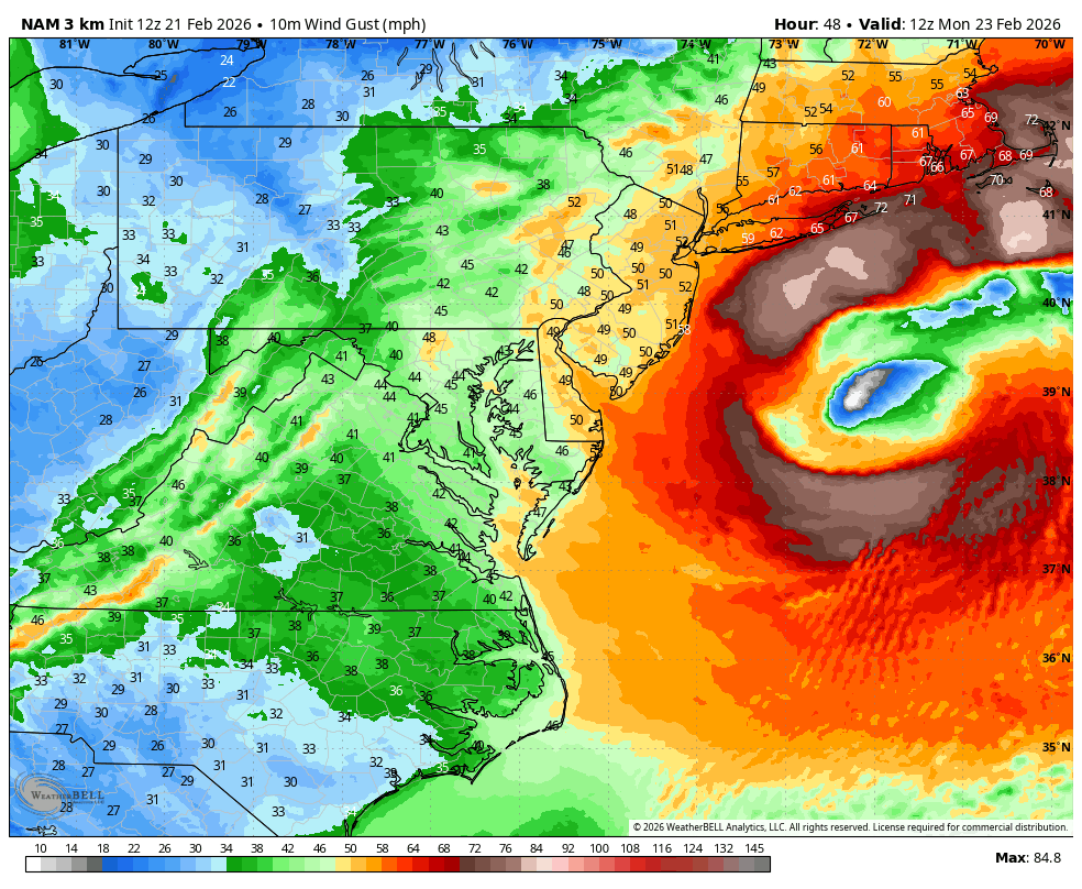
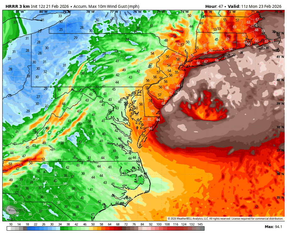
WB 18Z 3K NAM wind gusts 40-50 are widespread developing by midnight Sunday and lasting for a good part of Monday.
-
2/22-23 "There's no way..." Storm Part 2
Weather Will replied to Maestrobjwa's topic in Mid Atlantic
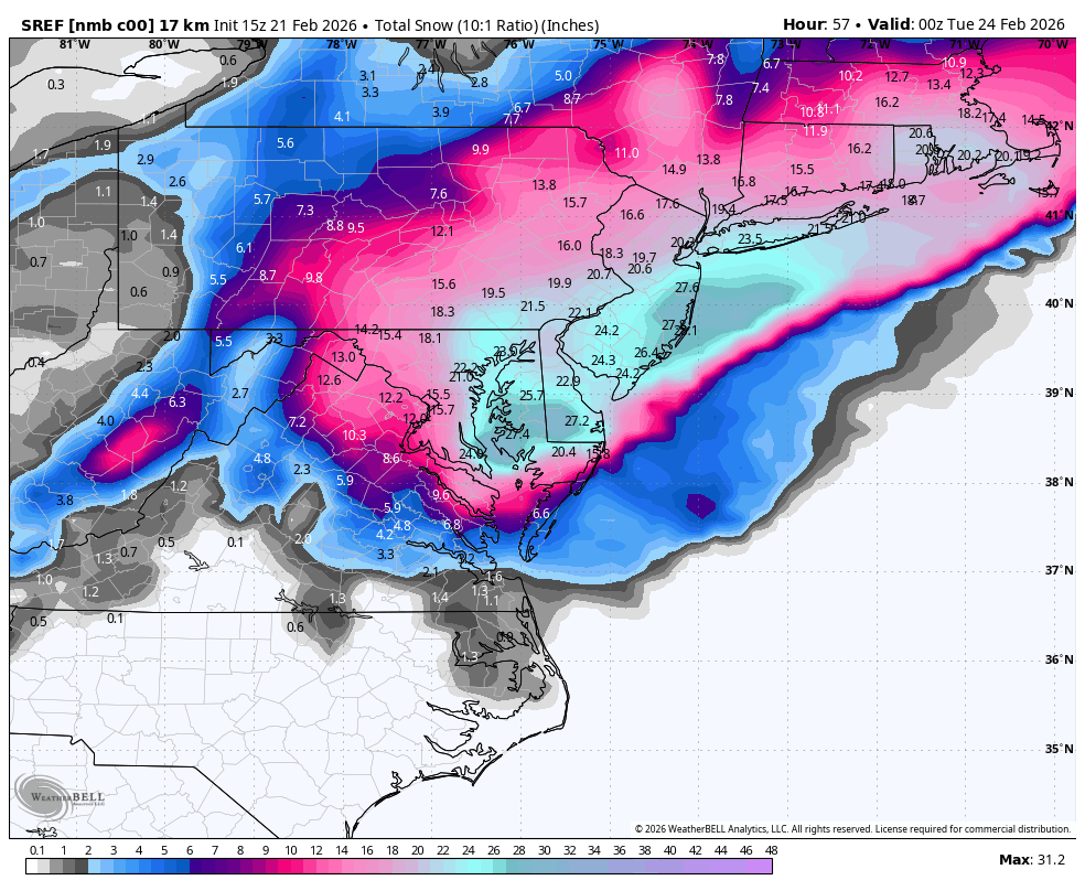
Think someone said NAM runs off the NMB? Here is WB 15Z SREF NMB...
-
2/22-23 "There's no way..." Storm Part 2
Weather Will replied to Maestrobjwa's topic in Mid Atlantic
Nice run! Winds seem to peak with 40 mph gusts Monday am. Snowcrete followed by snowcane!
-
2/22-23 "There's no way..." Storm Part 2
Weather Will replied to Maestrobjwa's topic in Mid Atlantic
WB 12Z 3K NAM is west with this run. However, way too warm everywhere during the day for much accumulation except maybe on grass/mulch. -
2/22-23 "There's no way..." Storm Part 2
Weather Will replied to Maestrobjwa's topic in Mid Atlantic
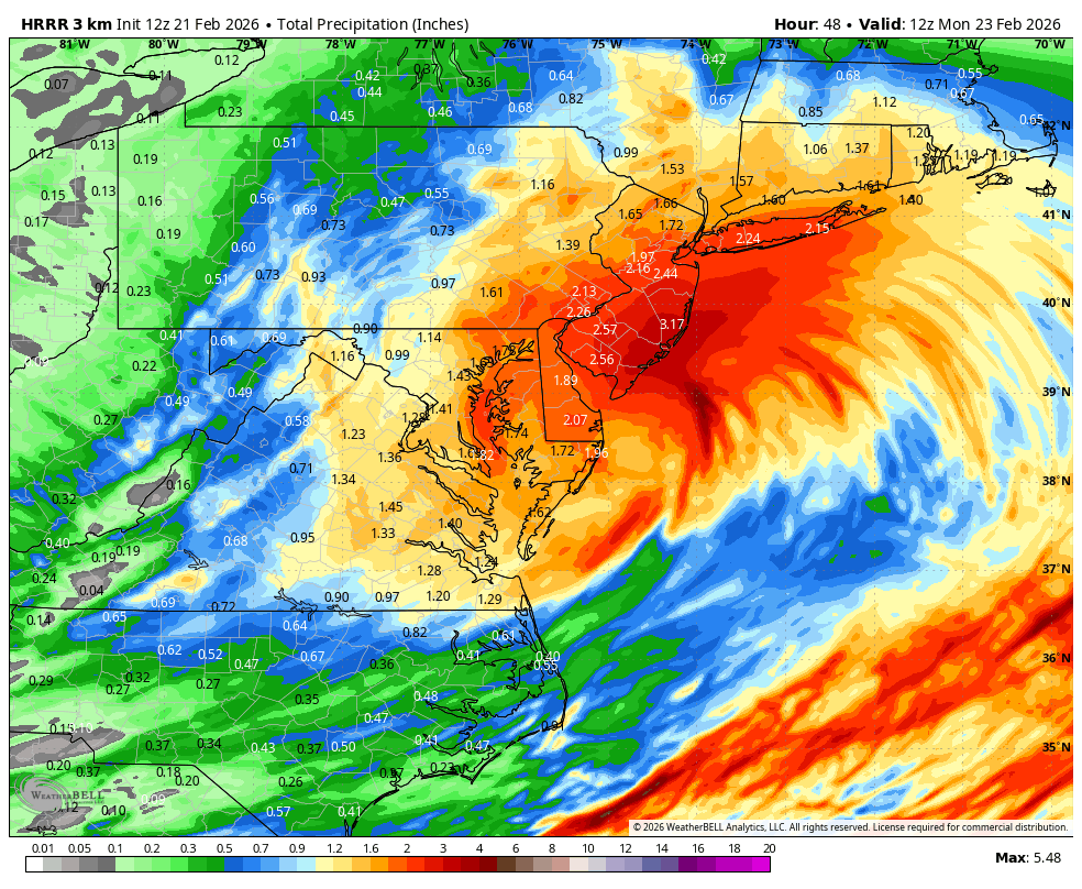
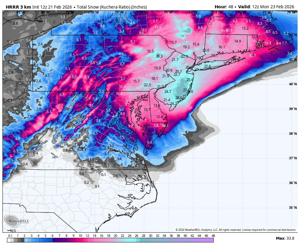
WB 12Z HRRR looked pretty good to me.

-
2/22-23 "There's no way..." Storm Part 2
Weather Will replied to Maestrobjwa's topic in Mid Atlantic
WB 6Z EURO zoomed on IVT
-
2/22-23 "There's no way..." Storm Part 2
Weather Will replied to Maestrobjwa's topic in Mid Atlantic
WB 6Z GFS

-
2/22-23 "There's no way..." Storm Part 2
Weather Will replied to Maestrobjwa's topic in Mid Atlantic
Hope you are correct!!! -
2/22-23 "There's no way..." Storm Part 2
Weather Will replied to Maestrobjwa's topic in Mid Atlantic
WB 3K NAM does intensify as it gets to our latitude and annihilates the eastern shore through southern NE. Just does not dig enough southwest to give us the goods.
-
2/22-23 "There's no way..." Storm Part 2
Weather Will replied to Maestrobjwa's topic in Mid Atlantic
6Z NAMs weaker so far, not as intense. Ex. WB 6Z 3K NAM 1 pm Sunday compared to 0Z. Not as intense, not consolidating energy and going negative tilt. -
2/22-23 "There's no way..." Storm Part 2
Weather Will replied to Maestrobjwa's topic in Mid Atlantic
WB 6Z HRRR low stalls off Delmarva, intensifies, and slowly slides East. Showing 9pm and 1am positions. Winds also a factor 20-50mph on the coast. Only thing keeping this from a crippling storm is surface temps which stay above freezing until 9-10 pm. If this is too warm, look out! -
2/22-23 "There's no way..." Storm Part 2
Weather Will replied to Maestrobjwa's topic in Mid Atlantic
WB 0Z ICON went west compared to 18Z. -
2/22-23 "There's no way..." Storm Part 2
Weather Will replied to Maestrobjwa's topic in Mid Atlantic
WB 0Z HRRR 7pm Sunday and more to go. We are being HRRR'D!!!! -
2/22-23 "There's no way..." Storm Part 2
Weather Will replied to Maestrobjwa's topic in Mid Atlantic
WB 0Z HRRR..look at the pressure leaning NW. -
2/22-23 "There's no way..." Storm Part 2
Weather Will replied to Maestrobjwa's topic in Mid Atlantic
0Z HRRR is amped big time. -
2/22-23 "There's no way..." Storm Part 2
Weather Will replied to Maestrobjwa's topic in Mid Atlantic
WB 18Z GEFS members about 22 (73%) are big hits for the entire region. Impressive. -
2/22-23 "There's no way..." Storm Part 2
Weather Will replied to Maestrobjwa's topic in Mid Atlantic
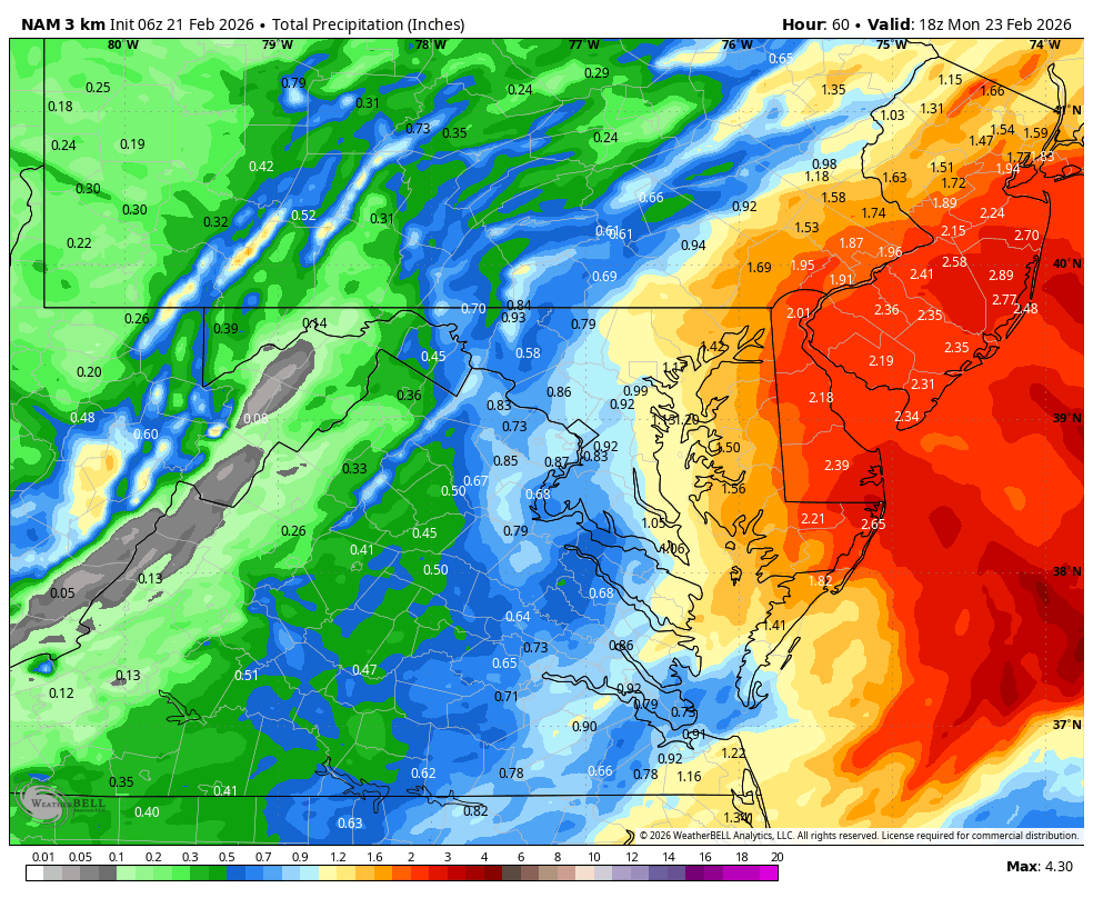
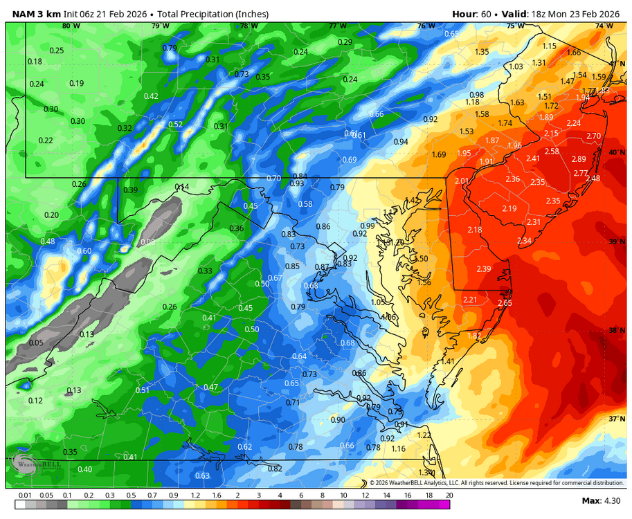
WB 3K NAM is now in range. Lot of white rain west of the Bay on Sunday unless the storm shifts west. -
2/22-23 "There's no way..." Storm Part 2
Weather Will replied to Maestrobjwa's topic in Mid Atlantic
Agreed, very little accumulation. -
2/22-23 "There's no way..." Storm Part 2
Weather Will replied to Maestrobjwa's topic in Mid Atlantic
WB 3K NAM noon Sunday. -
2/22-23 "There's no way..." Storm Part 2
Weather Will replied to Maestrobjwa's topic in Mid Atlantic
Are you all using 3K or 12k? Should really start using 3K I think.