ChiTownSnow
-
Posts
814 -
Joined
-
Last visited
Content Type
Profiles
Blogs
Forums
American Weather
Media Demo
Store
Gallery
Everything posted by ChiTownSnow
-
the manipulation was unintentional, you and storm are correct.
-
Totally agree. but even that is not THAT impressive is my point . i am clearly on my own here though.
-
not if you just accept the fact that its not that abnormal . but yeah probably
-
For Chicago: -The total number of 60 deg or warmer December days over 150 years has been 77 - the only December “Day” which has failed to produce a 60 at some point was dec 22nd So more often than not, we get a 60 degree day in December.
-
https://www.facebook.com/TomSkilling Skilling already posted the stats on the Facebook page regarding 60s in December for Chicago.. again not that impressive as you would think..
-
And I'll show you where you can put those stats..haha
-
Remember when this is still 174 out :).. but yeah agree it's been pretty consistent. The models backed off a bit sub 100 hours out on the warm up for the 10th. It'll be warm for sure but maybe it'll also back off a bit before then.
-
I guess.. have fun drowning your sorrows in your lack of snow for December 7th. I'll go enjoy the rest of the season
-
We can go back and forth if you want, but this stat is really not all that impressive or even that abnormal in the bigger picture for December 7th. It's like a batting average in the first 10 games of season. nor should it be used as an indication of how well the upcoming season will pan our.. but go ahead and start counting the minutes and seconds as well I guess
-
It sounds like that's exactly what the argument is. Some are making it seem like this is the worst December ever, this December is so terrible, and It never snows in December anymore..etc But yes, I won't and shouldn't argue a statistic, it is getting very late for measurable snow. But the statistic is not all that impressive to me I guess. People maybe using that statistic to indicate such a terrible start to the year
-
And I'm sure there are 10 more years of 1.1-2 inches this far. Big deal. You can find a statistic to support a view.
-
If the 240 verifies then I agree that would suck. But it hasn't yet, and what we've seen thus far isn't that bad
-
I'm not arguing against any of that. I'm saying what we have actually seen thus far is not that abnormal
-
Agreed I've been following these forums for 4 or 5 years now and when I first started following, everybody was tracking the big dogs and hyping each model run as if it was God. Then it switched to not trusting the models at all, and now its kind of all over the place.. just an observation
-
I think it means we're taking the calendar and time of year into consideration
-
Some of us are looking at what's happening now and not constantly 10 days out. Right now seems pretty normal
-
Assuming it verifies, i'm ok with 2 days of 50s with cold shots on both sides. I'd rather have that than the opposite
-
We've hit a low when we are posting barely ice pictures
-
Yeah..it's not that uncommon to have less than 3 in of snow at this point in time. Even in the years where we had more by now, it's probably 4 in or something really close
-
We go through this every December... I get that we can pull up statistics about latest snow or least amount of December snow..etc.. but we're generally talking about a few inches as of this time in December for most of us... Slow start yes. But time is on our side so far
-
Ha.. I wish it was the real Cook county
-
That's kind of my point.. there's not much that's not useless 240 out unless it's a consistent signal over time. I would have to be consistent in the 150 to 240 range in my opinion.
-
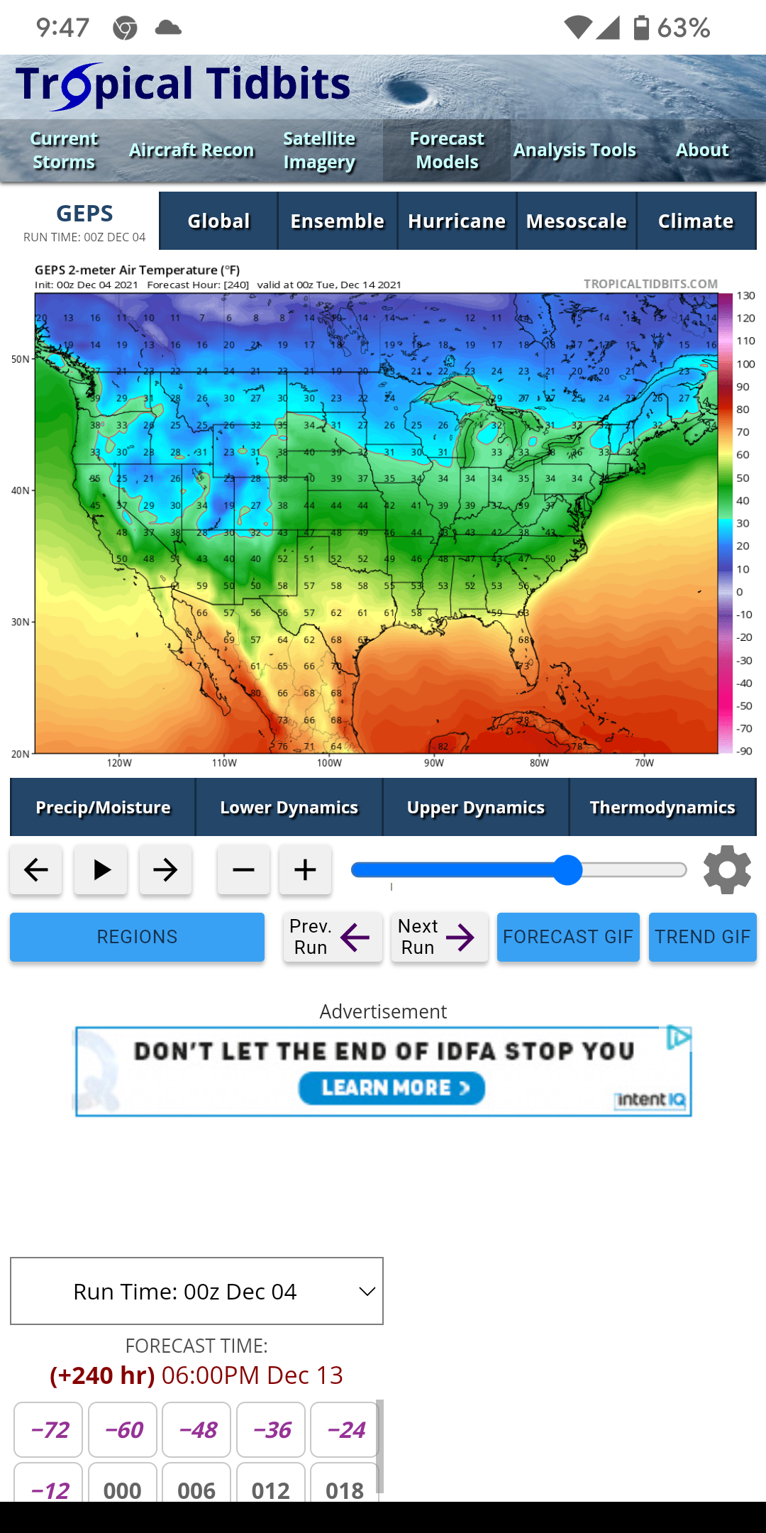
The corresponding air temperature on the ensemble for that same time period isnt that bad. Honest question: are these maps all driven from the same data set based on model output?
-
Yeah I didn't look close at ur map.. still 240 out. I don't trust anything over 150.. regardless of how strong of a signal it is
-
Why do we always trust these maps 240 hours out? We never trust anything else 240 out?