ChiTownSnow
-
Posts
814 -
Joined
-
Last visited
Content Type
Profiles
Blogs
Forums
American Weather
Media Demo
Store
Gallery
Everything posted by ChiTownSnow
-
January 30-February 1 Winter Storm Part 2
ChiTownSnow replied to Hoosier's topic in Lakes/Ohio Valley
Can we expect to see that heavy band make it's way north to ORD? -
January 30-February 1 Winter Storm Part 2
ChiTownSnow replied to Hoosier's topic in Lakes/Ohio Valley
That pretty orange stuff going to make it's way north? Or stall out where it is? -
January 30-February 1 Winter Storm Part 2
ChiTownSnow replied to Hoosier's topic in Lakes/Ohio Valley
The heavier band that went through here definitely had better flake size and seemed drier. -
January 30-February 1 Winter Storm Part 2
ChiTownSnow replied to Hoosier's topic in Lakes/Ohio Valley
Had a nice band go through.. moderate snow and nice size flakes. Wind even kicked up under the heavier returns. Lasted about 20 min and now back to very light snow -
January 30-February 1 Winter Storm Part 2
ChiTownSnow replied to Hoosier's topic in Lakes/Ohio Valley
Yeah.. Sticking to roads already here. Good start anyway -
January 30-February 1 Winter Storm Part 2
ChiTownSnow replied to Hoosier's topic in Lakes/Ohio Valley
Solid moderate snow here now. Maybe 1/2 inch/hour rates... not as heavy and wet as I initially thought it would be -
January 30-February 1 Winter Storm Part 2
ChiTownSnow replied to Hoosier's topic in Lakes/Ohio Valley
What do the p types look like? -
January 30-February 1 Winter Storm Part 2
ChiTownSnow replied to Hoosier's topic in Lakes/Ohio Valley
Been watching that as well. I doubt it will trend colder between now and start time I'll trust the experts. But admitadly a little nervous -
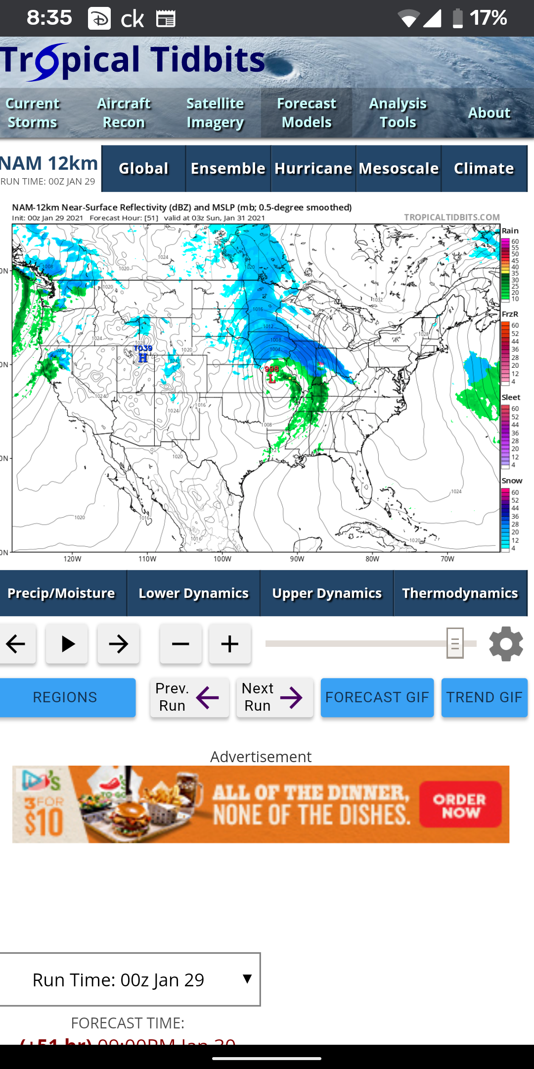
https://m.facebook.com/TomSkilling/posts/pcb.272433760908241/?photo_id=272433584241592&mds=%2Fphotos%2Fviewer%2F%3Fphotoset_token%3Dpcb.272433760908241%26photo%3D272433584241592%26profileid%3D30407707%26source%3D48%26refid%3D52%26__tn__%3DEH-R%26cached_data%3Dfalse%26ftid%3D&mdp=1&mdf=1 Skilling posting the RAP trend on FB. Pretty narrow band of heavy snow. Kinda goes along with the changes made by LOT to their snow map
-
Hoping for a window of clearing tonight to drop temps s much as possible before morning
-
Big differences to the south west as well. Dixon/Sterling area
-
Right.. That had me worried
-
I jumped the gun ..I was looking at hour 30
-
Looking at NAM I'm getting a little worried about mixing issues.. starting to look more like the GFS
-
https://www.spc.noaa.gov/exper/sref/srefplumes/index.php Mean on the Plumes ticked up to 9 at ORD.
-
What's with little wave ahead/north into MN that looks to hook up with it? Gives Wi and MN some decent snows. How might this impact us positively or negatively?
-
I hear we are in good hands with the official measurement at Ohare. Maybe they will give us a bump if that happens
-
I know. Something about discarding a major model though
-
I have a hard time discounting it completely though.
-
Prays To the snow gods one more time.. Goes back to bed
-
In agreement at least
-
Precip south as a result?
-
Blessing and a curse.
-
What's the difference between the GFS and the V16.. is one just an upgraded version in beta?
-
Agreed. But models were not in a general agreement 3 days out either. But point taken