rockchalk83
-
Posts
400 -
Joined
-
Last visited
Content Type
Profiles
Blogs
Forums
American Weather
Media Demo
Store
Gallery
Everything posted by rockchalk83
-

MO/KS/AR/OK 2022-2023 Winter Discussion
rockchalk83 replied to JoMo's topic in Central/Western States
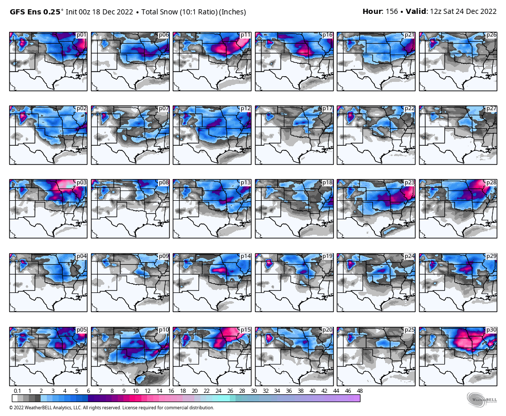
00z GFS Ens snowfall (10:1 ratio) thru 12z Sat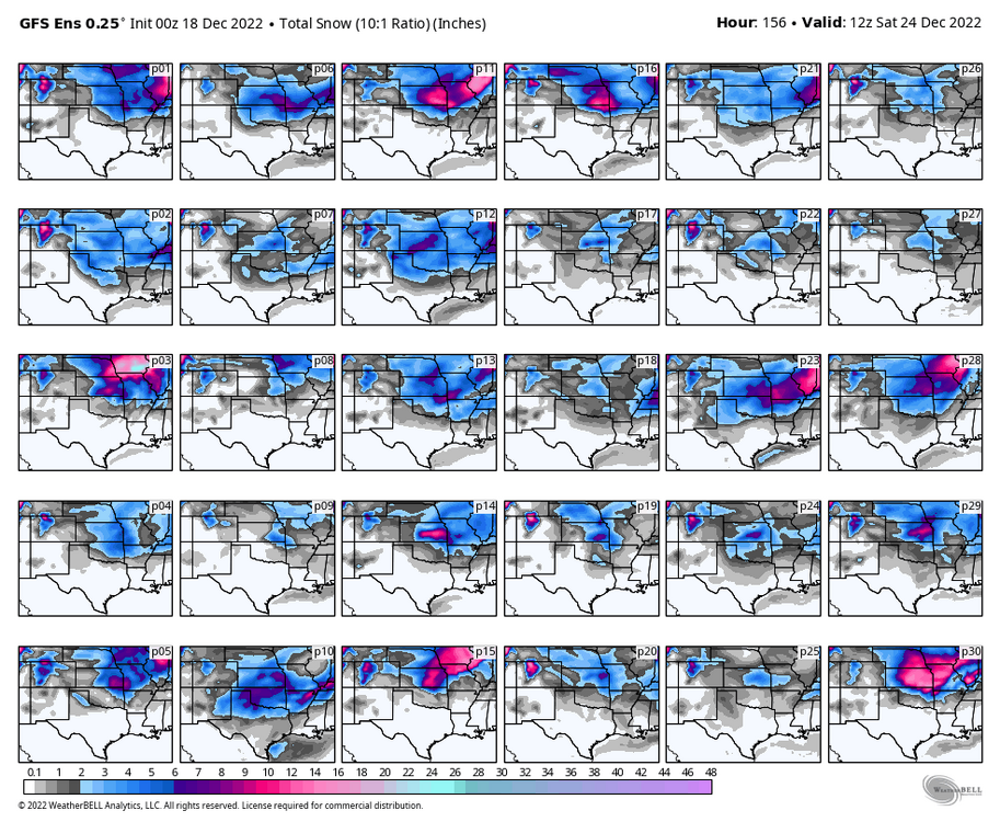
-
MO/KS/AR/OK 2022-2023 Winter Discussion
rockchalk83 replied to JoMo's topic in Central/Western States
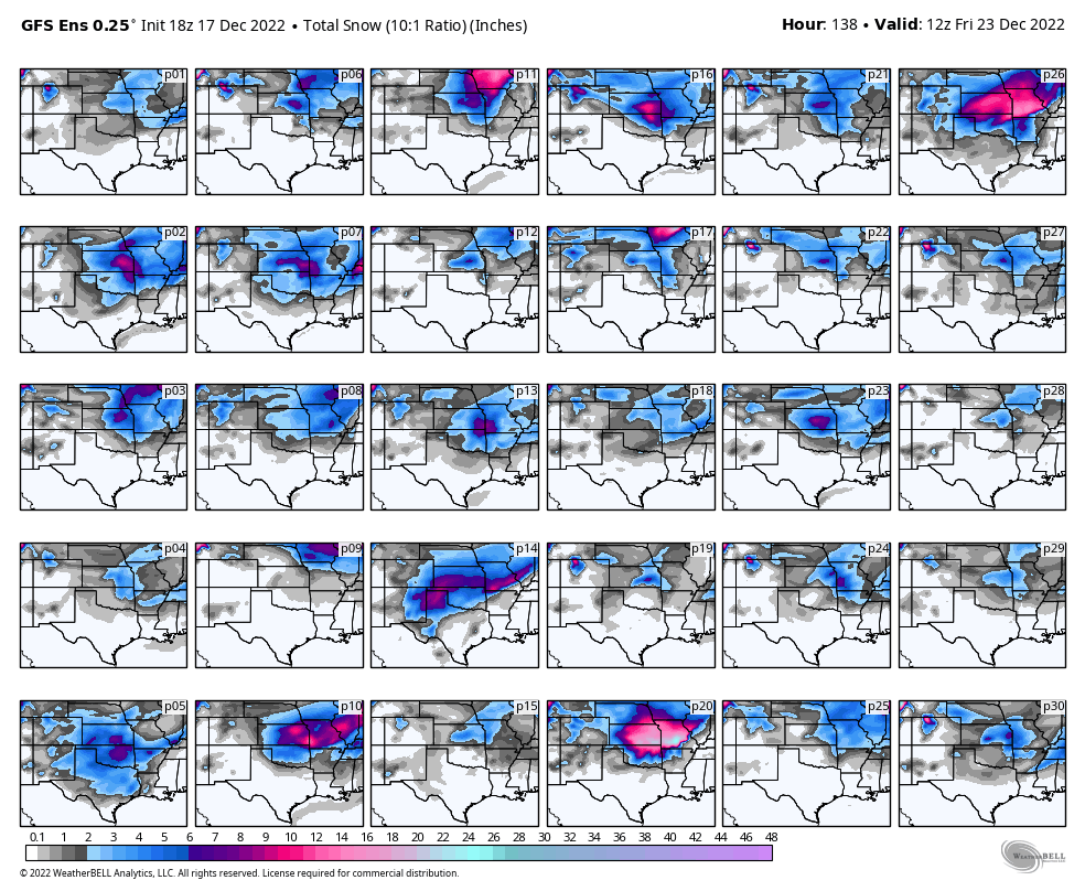
18z GEFS thru 12z Friday. Some huge hits here: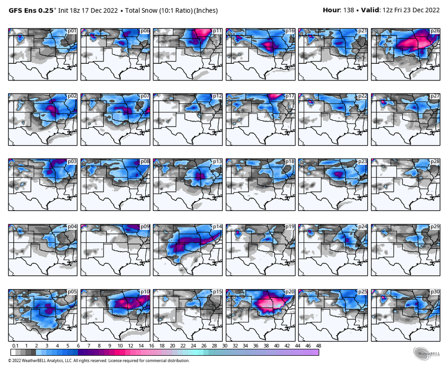
-
MO/KS/AR/OK 2022-2023 Winter Discussion
rockchalk83 replied to JoMo's topic in Central/Western States
There was a trend toward the GFS in the 12z run. We'll see what 00z looks like. And, the Euro ENS mean does show more moisture in the area vs. the operational run for Thursday. EDIT: Multiple Euro ENS members do have big hits for our area. -
MO/KS/AR/OK 2022-2023 Winter Discussion
rockchalk83 replied to JoMo's topic in Central/Western States
I hate this feeling that we could be headed for a let down. But, we're at weather's craps table....so let it ride. -
MO/KS/AR/OK 2021-2022 Winter Discussion
rockchalk83 replied to JoMo's topic in Central/Western States
Time for modeling is over. Nowcasting mode is on. Good luck, everyone! -
MO/KS/AR/OK 2021-2022 Winter Discussion
rockchalk83 replied to JoMo's topic in Central/Western States
I'm sure everyone would check 'YES' here:
-
MO/KS/AR/OK 2021-2022 Winter Discussion
rockchalk83 replied to JoMo's topic in Central/Western States
How are we feeling, everyone? This definitely looks like the most impactful winter storm our forum has had in sometime! Have you all chucked the global models and started looking at short-term stuff? -
MO/KS/AR/OK 2021-2022 Winter Discussion
rockchalk83 replied to JoMo's topic in Central/Western States
That is a really good point on a possible failure mode, at least for us out here. If there's any consolation, I would say the NAM is too warm in the mid-levels and at the surface. IMO I don't think we're going to have sleet with 925 mb, 850 mb, and 700 mb temps around -5C at 6z Wed. Once the precip starts, it should cool the column sufficently to change us to all snow. And all the models suggest that the precip rapidly expands and intensifies after midnight tomorrow into Wednesday. I think we'll do all right here, but to jack, we need to get under a band that doesn't move. It's been 13 months since the last >6" snowfall here. I'm prepared for doom here too, man. But, we do need the moisture. -
MO/KS/AR/OK 2021-2022 Winter Discussion
rockchalk83 replied to JoMo's topic in Central/Western States
12z GFS back to a solid snowstorm for C & S KS, N OK into SW-C MO. -
MO/KS/AR/OK 2021-2022 Winter Discussion
rockchalk83 replied to JoMo's topic in Central/Western States
Agreed on the NAM as a whole, but would you say the highest confidence in significant snow impacts is from C KS into C MO? Also, saw the models average Kuchera ratios between 14 & 15:1 for this event, do you think that's accurate? -
MO/KS/AR/OK 2021-2022 Winter Discussion
rockchalk83 replied to JoMo's topic in Central/Western States
The 18z GFS hasn’t run yet. That’s from 12z. -
MO/KS/AR/OK 2021-2022 Winter Discussion
rockchalk83 replied to JoMo's topic in Central/Western States
Kuchera may be better where the cold air is deepest (eg S KS, WC into C MO, and NW OK). There, SLRs could be 15:1, similar to what we had out here on New Year's Day. -
MO/KS/AR/OK 2021-2022 Winter Discussion
rockchalk83 replied to JoMo's topic in Central/Western States
Admittedly, I am. But here in southern Kansas, what will mess it up is if the high pressure comes in and shoves everything farther south...which has been the trend in the last 24 hours, at least in the deterministic models. The ensembles still hold on to the baroclinic zone farther north, on average. -
MO/KS/AR/OK 2021-2022 Winter Discussion
rockchalk83 replied to JoMo's topic in Central/Western States
@StormChazergot the hookup on Euro maps? I’m out with the wife at a Sam’s Club that doubles as a zoo. -
I had been wondering this same thing for the last couple days.
-
MO/KS/AR/OK 2021-2022 Winter Discussion
rockchalk83 replied to JoMo's topic in Central/Western States
Just looking at the models & their ensembles from this morning, it looks like the general theme is for the cold front to stall somewhere in northern or central Oklahoma during the day Tuesday, with precip developing out ahead of an upper air disturbance Tuesday night and continuing into Wednesday. If I were to forecast this, I would hedge the front/baroclinic zone and associated precip farther south, due to the dense nature of the colder air. Still though, think this is a good shot for all of us to see some much needed moisture and snowfall, but the bigger story, to me, is the colder air that will come down on the backside of this. Temps will likely be pretty cold for four or five days after the storm passes by. -
You have a truly unenviable spot in deciding whether to pull down forecast numbers or not. Oof.
-
Generally, how have the meso models done with situations like this in your region? Do you see signs in any of them that this will tick back NW. Watching all of this from Kansas, as there's been nothing worth following out here since the big windstorm on December 15.
-
MO/KS/AR/OK 2021-2022 Winter Discussion
rockchalk83 replied to JoMo's topic in Central/Western States
Would think that unless the baroclinic zone stops, that most of the region would get in on some form of wintry precip. The Canadian has mirrored the Euro to some extent with two waves of precip along a stationary front. I'm already living and dying by the models in the NE forum (yes, I'm a degenerate), Euro runs in an hour...let's see what happens. -
I wonder how much the above normal SSTs in the NW Atlantic is helping in the latent heat/meso low production process. Gotta think it has something to do with it.
-
MO/KS/AR/OK 2021-2022 Winter Discussion
rockchalk83 replied to JoMo's topic in Central/Western States
The storm system sliding down the Front Range of the Rockies had dumped 12-20" in a narrow band from west central Kansas into northeast Colorado. Euro & GFS show the possibility of snow showers in OK tomorrow into Thursday, not much accumulation though. Looking farther abroad, the models seem to be honing in on a busy period (anything would be considered "busy" after the winter we've had so far) beginning around next Monday. At least one storm shown on the main 12z model suite. Perhaps JoMo or some of the others can elaborate on the broader strokes behind the pattern change, but it looked to me that the MJO gets into phase 8 as the AO trends negative. -
MO/KS/AR/OK 2021-2022 Winter Discussion
rockchalk83 replied to JoMo's topic in Central/Western States
The development of a TROWAL feature is where the game will be played in this forecast. There maybe some concerns with the temps initially, but should see things quickly change over once you get into that band on the north side of the low. Where the southeast movement slows and begins an east progression, someone is going to get socked. Sure wish this would back up even 150 miles. It's parched out here in southern Kansas and the drought shows no signs of letting up. -
MO/KS/AR/OK 2020-2021 "Winter" Discussion
rockchalk83 replied to JoMo's topic in Central/Western States
Same here. It is interesting that some of the CAMs (NAMNest, WRF-NSSL namely) bring the snow shield just past the Kansas Turnpike. Also, Dodge City and several sites in SW KS have been seeing snow for a while now and I wonder if that's not some signs of a baroclinic zone developing. FWIW, none of the models had this developing.