rockchalk83
-
Posts
400 -
Joined
-
Last visited
Content Type
Profiles
Blogs
Forums
American Weather
Media Demo
Store
Gallery
Everything posted by rockchalk83
-

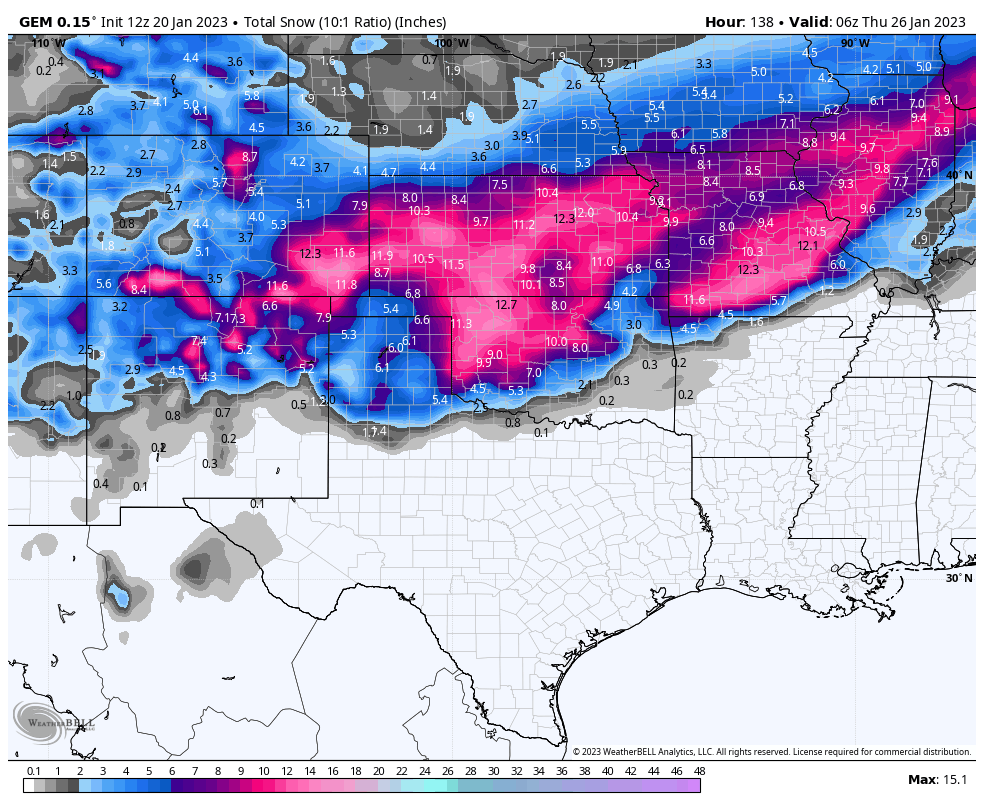
MO/KS/AR/OK 2022-2023 Winter Discussion
rockchalk83 replied to JoMo's topic in Central/Western States
Advisory out for south-central and southeast Kansas. Looking for 1-3" in metro Wichita, with higher amounts southeast of the Flint Hills. Though, the NAM may be onto something... -
MO/KS/AR/OK 2022-2023 Winter Discussion
rockchalk83 replied to JoMo's topic in Central/Western States
Break out the sad trombone for the southern Kansas folk. It's too warm for snow the system today, and the storm for Tuesday/Wednesday looks to be too far south to do anything, unless there's a drastic shift north. Bummer. On the plus side, western Kansas (where the heart of the D4 drought is,) is getting some much needed snowfall. Onward. -
MO/KS/AR/OK 2022-2023 Winter Discussion
rockchalk83 replied to JoMo's topic in Central/Western States
This 100%. Finally nice to see something around here other than tumbleweeds and duststorms. -
MO/KS/AR/OK 2022-2023 Winter Discussion
rockchalk83 replied to JoMo's topic in Central/Western States
Looks like thru hour 72 of the Euro, it's stronger with the 500 mb low in northern Arizona than it was on 00z run. There's a 537 dm circle centered near the AZ/NM line. So far, the trend overall with this run has been for a stronger, slightly farther north, system. -
MO/KS/AR/OK 2022-2023 Winter Discussion
rockchalk83 replied to JoMo's topic in Central/Western States
The Canadian model holds serve from its past several runs (this is combined for both tomorrow's and the Tue/Wed storm). Now we wait for the Euro.
-
MO/KS/AR/OK 2022-2023 Winter Discussion
rockchalk83 replied to JoMo's topic in Central/Western States
I have a hard time buying a foot plus to the I-44 corridor with marginal temps like the GFS is trying to sell. It's trying to do produce 3 inches of snow here in SC KS tomorrow with temps of 34-37 degrees. That said, dynamic cooling is an equalizer. -
MO/KS/AR/OK 2022-2023 Winter Discussion
rockchalk83 replied to JoMo's topic in Central/Western States
Just glanced at the 18z Euro Ensemble and it trended stronger and more northerly with the 25th system. Would be a decent hit for most here. -
MO/KS/AR/OK 2022-2023 Winter Discussion
rockchalk83 replied to JoMo's topic in Central/Western States
Color me intrigued -
MO/KS/AR/OK 2022-2023 Winter Discussion
rockchalk83 replied to JoMo's topic in Central/Western States
Looks like models give N OK 1-2" of snow Saturday night into Sunday. Not sure what to make of the storm aoa the 25th. Each model shows the range of possibilities with this. Upper lows that dig south across the Rockies are tricky. -
MO/KS/AR/OK 2022-2023 Winter Discussion
rockchalk83 replied to JoMo's topic in Central/Western States
We're down to 1/8 mile vis here in Wichita, heavy snow, blowing snow, fog. -5 with a wind chill of -32. North winds to 50 mph, but we've gusted higher. The -32 wind chill is the lowest reported value here since 2000. First snow squall warning issued for our area this morning. We won't verify a blizzard in all likelihood, but this has been one gnarly ass storm. -
MO/KS/AR/OK 2022-2023 Winter Discussion
rockchalk83 replied to JoMo's topic in Central/Western States
We have had light freezing drizzle/snow grains most of the day here in Central Kansas. It's the lift ahead of the front. Once that passes, it should be over. -
MO/KS/AR/OK 2022-2023 Winter Discussion
rockchalk83 replied to JoMo's topic in Central/Western States
18z Euro trended up again. Map is centered on Kansas.
-
MO/KS/AR/OK 2022-2023 Winter Discussion
rockchalk83 replied to JoMo's topic in Central/Western States
People are losing their minds. A little light freezing drizzle/snow grains. Winter time in Wichita. -
MO/KS/AR/OK 2022-2023 Winter Discussion
rockchalk83 replied to JoMo's topic in Central/Western States
Good pull. Thanks for that. -
MO/KS/AR/OK 2022-2023 Winter Discussion
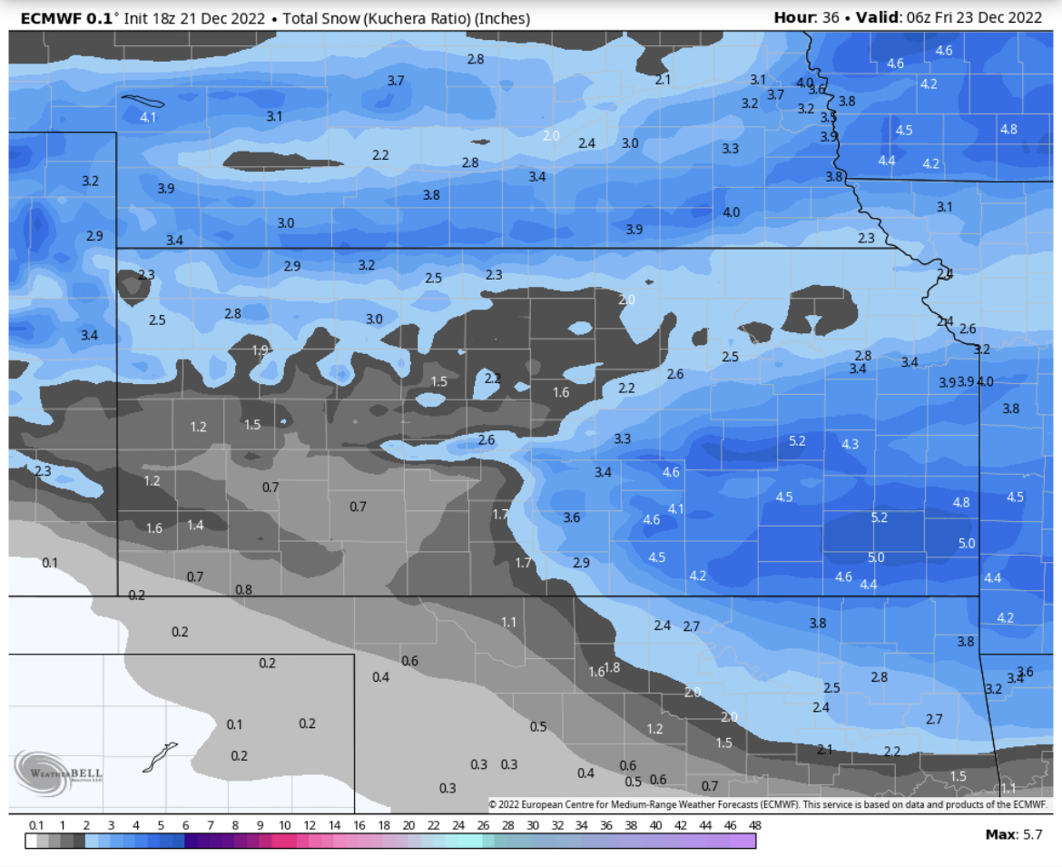
rockchalk83 replied to JoMo's topic in Central/Western States
I thought Kuchera only took into account the column temp below 500 mb? I don't think wind factors into any of the SLR equations at all. Still, though, I see where you're going. The wind is going to shred the dendrites and make them smaller, thus, harder to accumulate. -
MO/KS/AR/OK 2022-2023 Winter Discussion
rockchalk83 replied to JoMo's topic in Central/Western States
Color me intrigued. If the afternoon high-res models continue to latch on, it maybe wagons up (slightly) with snowfall totals out here. But like Wx 24/7 was saying, this is going to be a crazy 36-48 hours for everyone. -
MO/KS/AR/OK 2022-2023 Winter Discussion
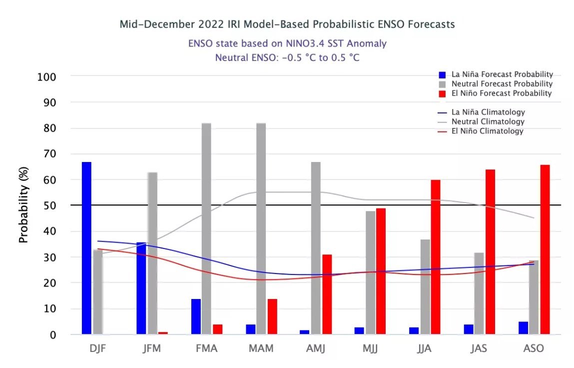
rockchalk83 replied to JoMo's topic in Central/Western States
Looking ahead, it does appear La Nina is (thankfully) beginning to loosen its grip and we'll be moving back into more of an ENSO neutral phase for the JFM period. Hopefully this will help back the storm track up and give us all some much needed moisture.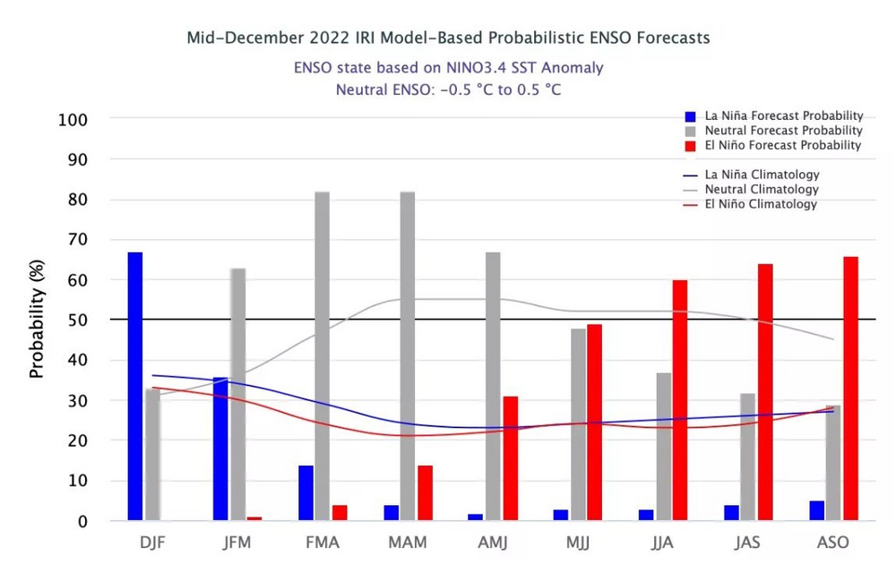
-
MO/KS/AR/OK 2022-2023 Winter Discussion
rockchalk83 replied to JoMo's topic in Central/Western States
We take. -
MO/KS/AR/OK 2022-2023 Winter Discussion
rockchalk83 replied to JoMo's topic in Central/Western States
The Icon has the right idea. Cold air is dense and always moves faster than forecast. -
MO/KS/AR/OK 2022-2023 Winter Discussion
rockchalk83 replied to JoMo's topic in Central/Western States
Yeah that feels like the safe bet here, but it wouldn't shock me to see a blizzard warning either...given we'll have >50 mph winds as the snow is falling. -
MO/KS/AR/OK 2022-2023 Winter Discussion
rockchalk83 replied to JoMo's topic in Central/Western States
The trend has not been kind to most of us in the last 12-18 hours. Models shifting away from a more amplified/west solution to one where the energy wraps up east of our domain, with a handoff at the east coast. Bottom line continues to be, as it always has been, the major cold coming. Very low wind chills of -10 to -30 possible for everyone by Friday morning. -
MO/KS/AR/OK 2022-2023 Winter Discussion
rockchalk83 replied to JoMo's topic in Central/Western States
The cold air is going to move faster than any model is predicting. I would use caution in the GFS’ interpretation of the polar front. Looks about 8-12 hours too slow to me. -
MO/KS/AR/OK 2022-2023 Winter Discussion
rockchalk83 replied to JoMo's topic in Central/Western States
That makes sense. There is some backing of the low level flow at 925 and 850 mb as well, which would aid in the increased precip, too. I agree with you that the GFS is too wet for this setup. If that signal shows up later....hide the women and children. By far, the winds and cold will be the greatest societal impact from this, but the snow cannot be ignored. -
MO/KS/AR/OK 2022-2023 Winter Discussion
rockchalk83 replied to JoMo's topic in Central/Western States
Man, that's one juicy GFS run. I'm lost trying to figure out what the moisture source for the system is. But, if it happens like this....widespread blizzard conditions for a lot of folks. -
MO/KS/AR/OK 2022-2023 Winter Discussion
rockchalk83 replied to JoMo's topic in Central/Western States
Support from the Canadian model for this system as well.