

rockchalk83
-
Posts
400 -
Joined
-
Last visited
Content Type
Profiles
Blogs
Forums
American Weather
Media Demo
Store
Gallery
Everything posted by rockchalk83
-

MO/KS/AR/OK 2020-2021 "Winter" Discussion
rockchalk83 replied to JoMo's topic in Central/Western States
Is the wave deeper on the Euro, or something else forcing it south? -
MO/KS/AR/OK 2020-2021 "Winter" Discussion
rockchalk83 replied to JoMo's topic in Central/Western States
Agreed completely. Wave amplitude is my biggest concern right now. Thankfully, this should start getting better sampled later today and tonight. -
MO/KS/AR/OK 2020-2021 "Winter" Discussion
rockchalk83 replied to JoMo's topic in Central/Western States
Looks like another big GFS run inbound.... -
MO/KS/AR/OK 2020-2021 "Winter" Discussion
rockchalk83 replied to JoMo's topic in Central/Western States
From reading AFD's this afternoon (believe Tulsa), NBM does not, since it's just loaded in from WPC. -
MO/KS/AR/OK 2020-2021 "Winter" Discussion
rockchalk83 replied to JoMo's topic in Central/Western States
With SLR's likely to be in the 25-30:1 range, it will be much easier to get white out conditions than we normally would. If the GFS is correct, such conditions are a lock for W KS, OK and parts of N TX. -
MO/KS/AR/OK 2020-2021 "Winter" Discussion
rockchalk83 replied to JoMo's topic in Central/Western States
Found it on WxBell....enjoy!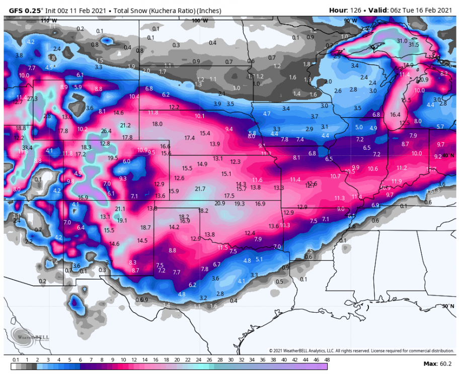
-
MO/KS/AR/OK 2020-2021 "Winter" Discussion
rockchalk83 replied to JoMo's topic in Central/Western States
Can't wait for the Kuchera clown map. -
MO/KS/AR/OK 2020-2021 "Winter" Discussion
rockchalk83 replied to JoMo's topic in Central/Western States
We’ve had light snow all week down here. So, we’re saturated and there has been just enough lift to make it happen. That changes this weekend. -
MO/KS/AR/OK 2020-2021 "Winter" Discussion
rockchalk83 replied to JoMo's topic in Central/Western States
One thing to keep in mind, the snow will be falling into brutally cold temps (near zero and below). Here's a look at Monday morning wind chills, with a north wind at 10-15 mph. Wind chills like these will have a huge impact on people outdoors and cattle.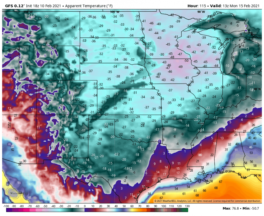
-
MO/KS/AR/OK 2020-2021 "Winter" Discussion
rockchalk83 replied to JoMo's topic in Central/Western States
Indeed. Good group of fellow weather nerds here. Here’s hoping the next week is good for everyone. -
MO/KS/AR/OK 2020-2021 "Winter" Discussion
rockchalk83 replied to JoMo's topic in Central/Western States
The Canadian model appears to be a huge wet blanket for everyone the next few days. But, it does have 6-10 inches in the Texas Hill Country (skeptical). -
MO/KS/AR/OK 2020-2021 "Winter" Discussion
rockchalk83 replied to JoMo's topic in Central/Western States
Just downright nuts. -
MO/KS/AR/OK 2020-2021 "Winter" Discussion
rockchalk83 replied to JoMo's topic in Central/Western States
Looks like a 1-3" event here Friday into Saturday, but a more substantial event for the late weekend period. This does appear to be a more aggressive run of the Euro, so we'll see what the ensembles say. -
MO/KS/AR/OK 2020-2021 "Winter" Discussion
rockchalk83 replied to JoMo's topic in Central/Western States
The 12z GFS Ensembles backed off on the amount of precip with the weekend system, but still has >6" for most of our area in the next 240 hours. Let's see what the Euro does. -
MO/KS/AR/OK 2020-2021 "Winter" Discussion
rockchalk83 replied to JoMo's topic in Central/Western States
If anything, the NAM looks a little more bundled and deeper with the energy than the GFS does...at least that what my eyes tell me. I think the runs today and tomorrow will be interesting to see which side wins out here. -
MO/KS/AR/OK 2020-2021 "Winter" Discussion
rockchalk83 replied to JoMo's topic in Central/Western States
Not good, Bob. I wonder why the major change? I wonder if there was a major wave buckle in the Pacific that led to the pattern change? -
MO/KS/AR/OK 2020-2021 "Winter" Discussion
rockchalk83 replied to JoMo's topic in Central/Western States
It’s quite possible that I’m salivating after looking at that. -
MO/KS/AR/OK 2020-2021 "Winter" Discussion
rockchalk83 replied to JoMo's topic in Central/Western States
The forecast high for Wichita today is 18. We've had light snow all morning long (snowing at a decent clip right now)...there's no shot we get to 18 if this continues. Temps falling into the single digits 30-40 miles north of here. And as for the 12z GFS, if that's crazy....sign me up! If we're going to go big with the cold, let's go big with the snow. -
MO/KS/AR/OK 2020-2021 "Winter" Discussion
rockchalk83 replied to JoMo's topic in Central/Western States
I’m not near my computer to look, but are the GFS and Canadian still showing snowy and cold solutions? -
MO/KS/AR/OK 2020-2021 "Winter" Discussion
rockchalk83 replied to JoMo's topic in Central/Western States
To what? -
MO/KS/AR/OK 2020-2021 "Winter" Discussion
rockchalk83 replied to JoMo's topic in Central/Western States
Still snowing hard here. 6" and we're snowing at 1-2"/hr again. Winds are picking up, too, so we're seeing whiteouts. -
MO/KS/AR/OK 2020-2021 "Winter" Discussion
rockchalk83 replied to JoMo's topic in Central/Western States
The Euro/Canadian sniffed out the overall trend first. Feel for SC KS, the Euro did the best. Short term models were a little too far southeast with the heaviest band. -
MO/KS/AR/OK 2020-2021 "Winter" Discussion
rockchalk83 replied to JoMo's topic in Central/Western States
Started snowing here in Wichita about 4 am...have picked up 4" (2" between 7 & 8 am) and it's still snowing. Biggest storm since 2014. -
MO/KS/AR/OK 2020-2021 "Winter" Discussion
rockchalk83 replied to JoMo's topic in Central/Western States
I am right there with you on all those points. One other question I’ll throw in is how far west does the main deformation precip shield get. I have a hard time buying the razor thin cut off that some are showing, but that may just be wishful thinking. The latest model runs give me even more pause that the streak won’t end tomorrow, but it’s time to nowcast this out and see how it evolves. Good luck and happy new year to all! We survived 2020. -
MO/KS/AR/OK 2020-2021 "Winter" Discussion
rockchalk83 replied to JoMo's topic in Central/Western States
I hope you’re right....but I’m naturally pessimistic. 7 years of little snow does that to you. Haha.


