

BTRWx's Thanks Giving
-
Posts
3,026 -
Joined
-
Last visited
Content Type
Profiles
Blogs
Forums
American Weather
Media Demo
Store
Gallery
Posts posted by BTRWx's Thanks Giving
-
-
1 minute ago, CAPE said:
Goddamn dude you haven't learned a thing here have you?
This is banter.
-
4 minutes ago, CAPE said:
As modeled it wouldn't here. Got the banding and the rates.

-
 1
1
-
-
1 minute ago, CAPE said:
Had to post this for the lolz.

There's no way that would happen if rain mixes in for longer.
-
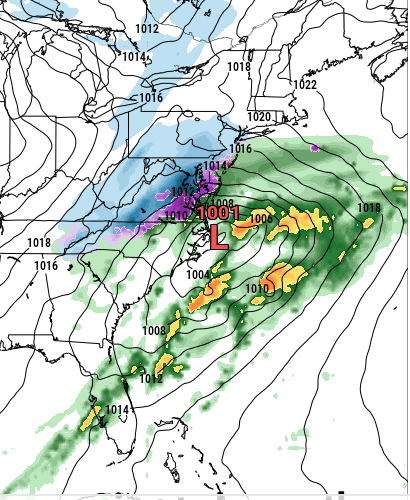
THE 3km NAM is a disaster! It mixes with rain on and off throughout the event in D.C.
-
 1
1
-
-
Mike Thomas just circled the area between D.C. and Baltimore for best max potential on his Facebook live.
-
1 minute ago, HighStakes said:
It's not really a marginal event NW of 95.
It might be with qpf.
-
1
-
-
For what it's worth, Bob Ryan posted on Facebook that he doesn't like recent trends for D.C.
-
 2
2
-
-
1 minute ago, RedSky said:
The mystery map we know neither the time the month or the year or the model but it looks ok!
It's the snow depth map from the 12z euro.
-
-
Might be a little lighter than 0z.
-
1 minute ago, SnowenOutThere said:
The snow hole is right over me.
These types of posts are unneeded.
-
2 minutes ago, SnowLover22 said:
Hey look, it still shows a D.C. snow hole.
-
1 minute ago, WinterWxLuvr said:
We all aren’t celebrating that euro run lol
You will be with a couple more nw trends.
-
1 minute ago, IronTy said:
You prefer kuchera?

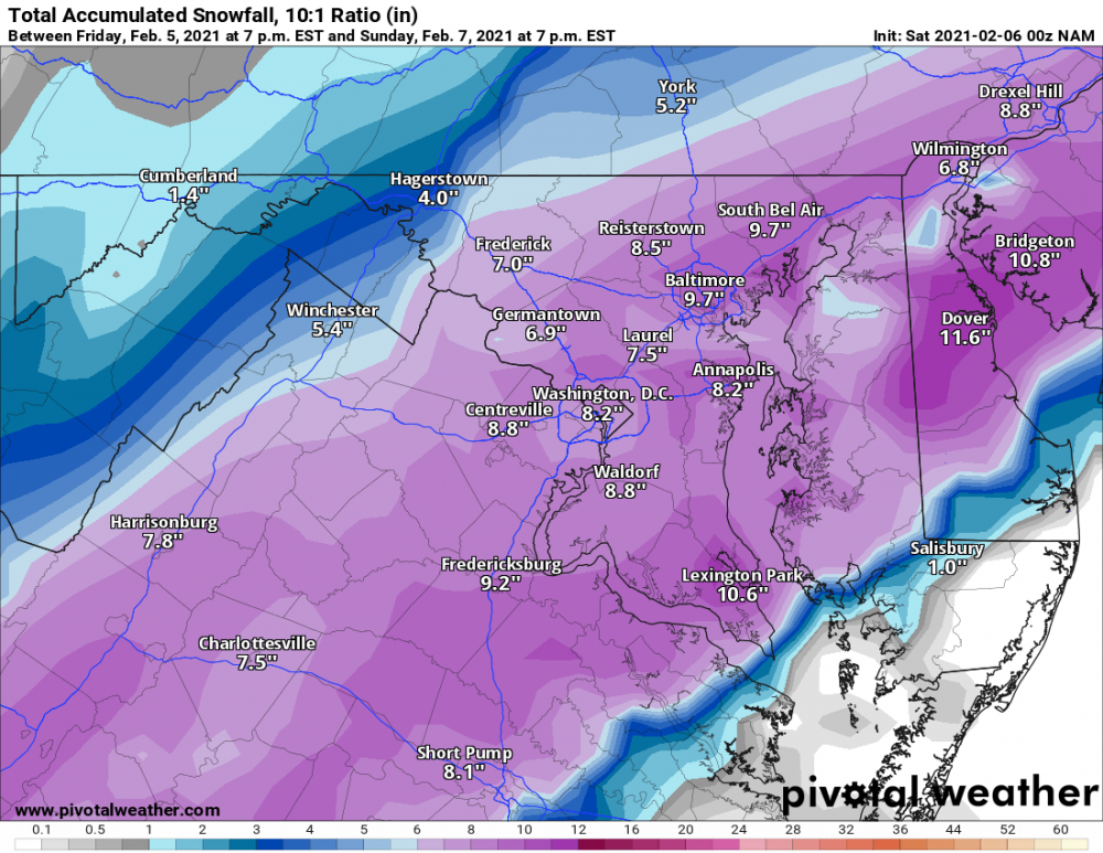
I'm surprised they look the same! Ttb depth map only shows 3-4" for D.C.
-
14 minutes ago, IronTy said:
That 3k tho....

Why are you showing 10:1?
-
The origin of the low gives hope that the storm could really blossom.
-
 1
1
-
-
2 minutes ago, CAPE said:
Next panel

What about total between the two?
-
1 minute ago, losetoa6 said:
I'm not ready to give up on Sunday yet . Gefs still with some nice hits in there.
Euro went from suppression to cutter in one run. No way is this over.
-
1 minute ago, Ralph Wiggum said:
Pretty big jump there
It's the control!
-
4
-
-
What happened to TropicalTidbits' para?
-
 1
1
-
-
3 minutes ago, SnowenOutThere said:
Could anyone post the 18z Euro model? It would be appreciated.
It just started running. We're all here for the same thing.
-
Nice snowy surprise to wake up to!
-
Radar continues to be so spotty.
-
Radar is filling in some sw of D.C.
-
1
-


February 7th Storm Threat Discussion/Obs
in Mid Atlantic
Posted
If rain mixes as long as the 3km NAM shows, this could be the result.