

BTRWx's Thanks Giving
-
Posts
3,026 -
Joined
-
Last visited
Content Type
Profiles
Blogs
Forums
American Weather
Media Demo
Store
Gallery
Posts posted by BTRWx's Thanks Giving
-
-
1 minute ago, Weather Will said:
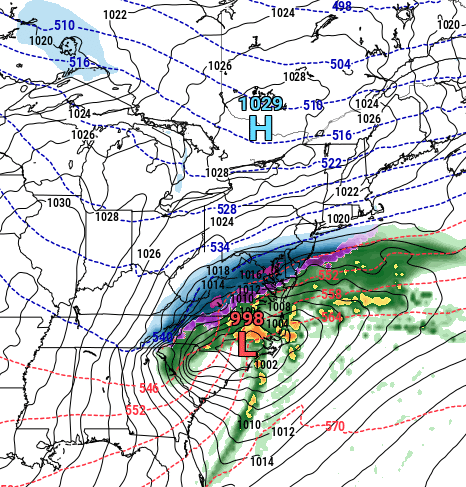
WB 18Z NAM 1am Mon


Not too shabby for AL.
-
2 minutes ago, WxMan1 said:
I haven't looked at it yet...
But I was just PMd to not look at the 18Z HRRR.

It's not that bad.
-
2 minutes ago, snowfan said:
CWG: 0-12"
That's not true.
-
1 minute ago, Solution Man said:
151 browsers….wow
That's nothing.
-
 2
2
-
-
3 minutes ago, SnowDreamer said:
8” as the “low end confident number” in South DC and DCA? That’s ballsy!
It's not realistic.
-
Truly amazing!
-
 2
2
-
 3
3
-
-
-
2 minutes ago, high risk said:
Sort of. Yes, the NAM (and RAP/HRRR and Hi-Res Windows) will be subsumed by a hi-res, hourly FV3 ensemble (called the RRFS), but the configuration of that hi-res FV3 is not what the configuration of the RRFS members will be (different physics, different initialization....). Think of this run that you showed as sort of a hi-res GFS for now.
What's the plan for the 3k NAM?
-
2 minutes ago, LeesburgWx said:
Who is doing pbp for the euro when it starts?
Everyone who knows how. lol
-
1
-
-
The early precipitation falling overnight helps.
-
Bastardi was right all along.
-
1
-
-
Beautiful

-
5
-
-
2 minutes ago, IronTy said:
00Z in the house

You're so late.
-
 3
3
-
-
3 minutes ago, Ephesians2 said:
if this even comes close to verifying, DC radio will probably get a lot of public criticism ... just heard WTOP say "a few flurries north and west" Monday morning
They're not wrong.
")
-
1
-
3
-
-
1 minute ago, NorthArlington101 said:
Who is that?
-
2 minutes ago, caviman2201 said:
Looking good after that first rain panel though... going to be a huge run for everyone. I mean thats a proper MA snowstorm look

Look how far north the 540 is!
-
1
-
-
1 minute ago, BristowWx said:
It’s hard to fathom for a layman like me to think the NAM is not seeing this at this range. It seems like at this range there would t be much difference between any of the models. It’s puzzling
He was just mentioning how the model is being replaced.
-
-
4 minutes ago, WinterWxLuvr said:
There’s plenty of time because it won’t take much in the way of changes. They only need be minor.
I did notice a nice high placement on the euro even though the system was slightly to the south.
-
2 minutes ago, H2O said:
I need this snow for various reason but I know better to think it will happen. North trends just mean more chance for sleet for me and the usuals will cash in just because they always do. Seen this before about a billion times.
Congrats Winchester and points NW yet again
There's not a lot of time for the system to come much farther north. We're within 48 hours! Losing it south is the biggest concern.
-
2
-
-
Calling PSU! If this continues into tomorrow, let's get that zoom call scheduled!
-
4
-
-
2 minutes ago, IUsedToHateCold said:
I’d love to see the 18z Euro agree with the GFS. If that happens I’d be less afraid of the NAM
That's a big run coming up!
-
1
-
-
1 minute ago, CAPE said:
Pretty odd to see such disparity like this given the start of the 'event' is inside of 40 hours. Easy to say its the goddamn NAM though so who cares lol.
That's la nina for ya!
-
1 minute ago, Snowmadness said:
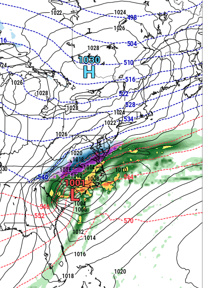
18Z HRRR


January 3, 2022 CAPE Storm Obs/Nowcast
in Mid Atlantic
Posted
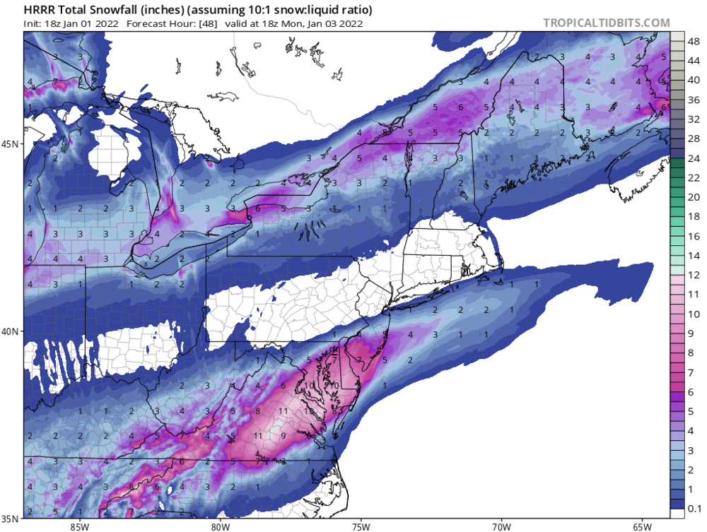
Wow that is a narrow swath of heavy snow!