

BTRWx's Thanks Giving
-
Posts
3,026 -
Joined
-
Last visited
Content Type
Profiles
Blogs
Forums
American Weather
Media Demo
Store
Gallery
Posts posted by BTRWx's Thanks Giving
-
-
It was a decent size storm imby, but last night was better.

-
2 minutes ago, alexderiemer said:
Seeing same but the velocity scan doesbt easily reflect that
Sent from my SM-G892A using Tapatalk
Could it be a microburst?
-
 1
1
-
-
2 minutes ago, alexderiemer said:
The VIL on that Charles Town cell is off the charts!


Sent from my SM-G892A using Tapatalk
TVS in that area per radarscope
-
I wonder if the activity over central Virginia becomes the source for the metro action? There hasn't been much forward movement from the complex.

-
1 minute ago, Kmlwx said:
LOL the latest HRRR has a tiny spec of 85kts on the wind gust product. Doubtful.
hrrrx is running too
-
1 minute ago, Eskimo Joe said:
I don't think we get a MOD risk after looking at the SPEC IAD sounding.
What's SPEC?
-
Where's the fuel for this line?
-
2 minutes ago, MillvilleWx said:
That record precip value in 1983 was not rain either
")
Strong nino
-
There's something about February ending winter nina droughts and other variables I haven't looked into yet.
-
On 1/27/2018 at 3:21 PM, BTRWx's Thanks Giving said:
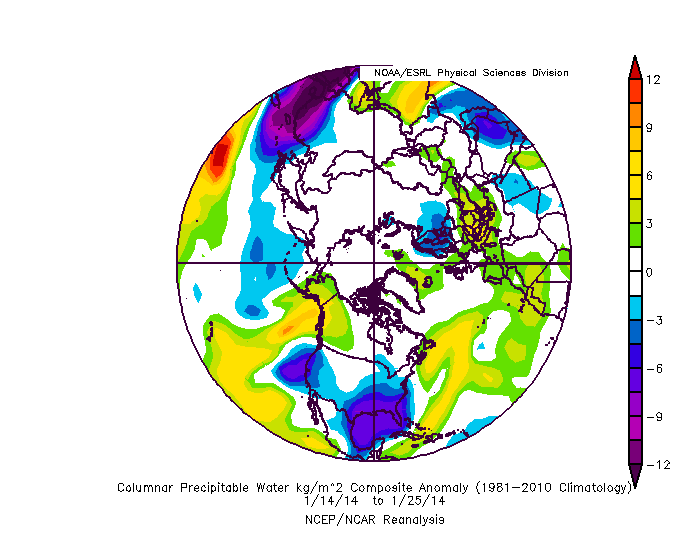
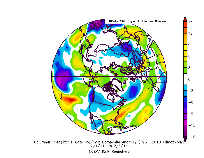
Fwiw, 2014 ended its drought big time the first week of February.
bump
-
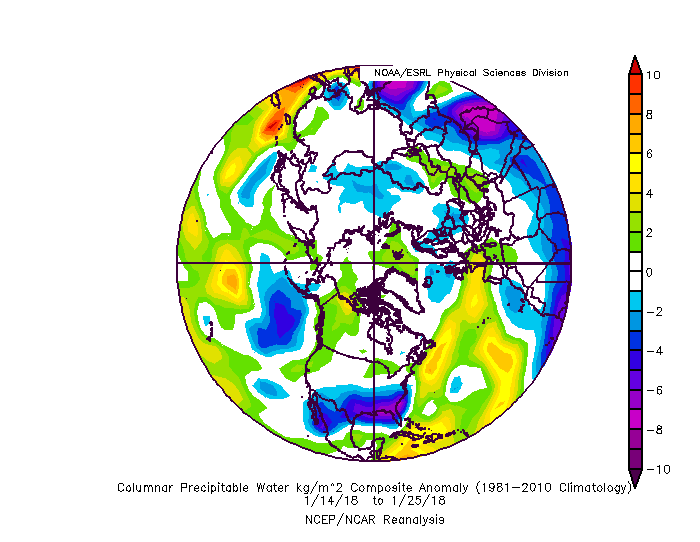
Fwiw, 2014 ended its drought big time the first week of February.
-
3 minutes ago, psuhoffman said:
What if we don't have NAO or 50/50 help. The best bet in that case is to root for a gradient boundary storm. A wave along the boundary mostly moving west to east of southwest to northeast. Something overly amplified is very unlikely to work in that setup. And it will require a better EPO to offset the other missing pieces. This is a good example.

Now we have a positive NAO and a WAR. You would think uh oh, but the EPO is textbook and again notice the center of the lower heights are to our north. In this case the setup places the boundary south of us and a wave was able to ride along and we win. The key here is where the lower heights set up downstream from the EPO placing us right along the boundary.
Early March 2014 is another example of a gradient boundary storm that worked out. Different moving parts but similar in that the lower heights centered to our north and a system rode the boundary set up through our area.
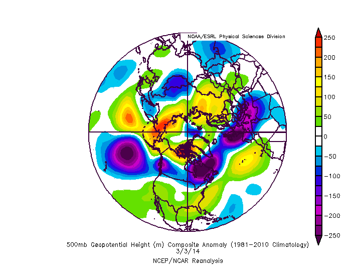
Gee, 3/3/14 looks atrocious from h5 alone. Very interesting!
-
4 minutes ago, psuhoffman said:
So I liked this example of a pretty good storm from 2004 across our area because it deals with the trade off between the PNA and atlantic. In this case the blocking and 50/50 location would be way too suppressed if it weren't for an absolutely crap pacific pattern.
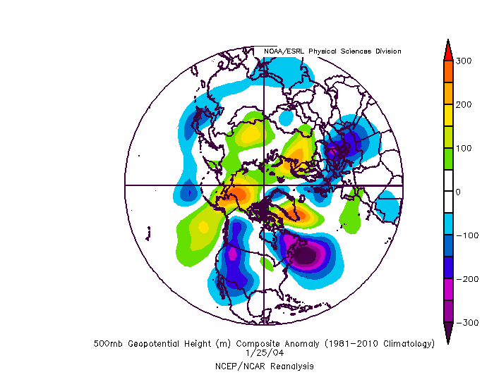

There is a trough in the west there but thats actually good here because look at where the 50/50 is. If it werent for the attempts to pop a ridge in the east and cut something to our west anything coming at us from the south would be suppressed. This worked out because the system tried to go west and was forced under us. So too much of a good thing in the atlantic was offset by what would normally be a worse PNA look. If we actually had what we usually consider a "good PNA" there it would have been cold/dry and a snowstorm along the southeast coast maybe.
Good stuff!
Interesting to see 2004 has the warm blob. -
5 minutes ago, EastCoast NPZ said:
2011, 12, &13?
2011 was no dud, but I see why you mentioned that.
No other 3 year span comes close to those though.eta: 1949-1953 may have been bad even with the low double digits overall, but the law of averages resulting from 2012-2013 ended in our favor.
")
-
On 1/16/2018 at 11:56 AM, stormy said:
I agree completely, we usually have more generous precipitation during an El Nino in winter because of a more active stj.
But, Jan. of 96 which was very wet averaged -0.9c. Go figure
I don't think dca has ever had 3 extreme dud winters in a row (though this year isn't done yet).
-
1 minute ago, psuhoffman said:
Crap you just unraveled this whole thing
Maybe the dynamics will reach the arctic faster to save us.
-
Just now, Cobalt said:
We obviously need to create a heated late in replacement of the Appalachian mountains. Sure, we'd lose CAD, but I'm pretty sure we'd be fine
Seed the valleys
-
2 minutes ago, NorthArlington101 said:
Wait... if our events are busting because we are in a drought, and hence it can’t rain/snow in a drought, are we literally going to be stuck in a drought forever? Has someone done the math?! Cancel the next 50 winters until global warming moves the ocean close enough to help us out.
The law of averages will win out eventually. We just might have to wait until spring.
-
1 minute ago, North Balti Zen said:
Wtf, my thread wasn’t good enough?
It's good enough. I'm a little behind the times.
-
1996 was an anomaly. Who can decipher?
-
I'll be rooting for you all!
2018 Mid-Atlantic General Severe Discussion
in Mid Atlantic
Posted
It was severe in Alexandria briefly.