

BTRWx's Thanks Giving
-
Posts
3,026 -
Joined
-
Last visited
Content Type
Profiles
Blogs
Forums
American Weather
Media Demo
Store
Gallery
Posts posted by BTRWx's Thanks Giving
-
-
Nobody wants a sports only thread?
-
Rooting for the Rockies for more October baseball in Denver!

Models start to show increasing variability into next week with the
intensity and placement of the upper trough. With that being said,
multiple models are trending to a more active and cooler pattern
into next week that could bring snow to the lower foothills by late
Monday and highs getting into the 50s for the plains.

-
This was mentioned as a pick of the week on weatherbrains last night. https://spaceweatherarchive.com/2018/09/27/the-chill-of-solar-minimum/
-
1 hour ago, psuhoffman said:
2004-05 wasn't that bad. After a bad start mid January on had several 3"+ snowfall events across the region with a few healthy clippers mixed in. We just missed a bigger storm a couple times too. But it certainly wasn't a dud. If anything it was the rare example of a median "average" snowfall winter. I wouldn't cry if we get a somewhat similar year.
Nothing special here. https://www.wunderground.com/history/monthly/us/dc/washington/KDCA/date/2005-1
-
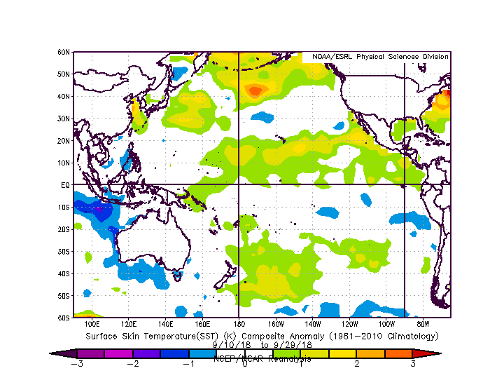
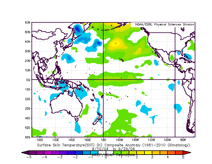
The closest sstas for mid - late September is 2004...slightly concerning
-
1 hour ago, frd said:
Interesting how things have flipped in terms of rainfall. Looks dry except for scattered storms later today ad then a record High Pressure ridge next week building oover the Eastern States. I look for very warm and dry weather. Funy the SOI continues to plummet yet temps here well above normal. I guess the second part of the month could turn out wetter as the EPS shows a pattern change after mid month.
Then my next step is to see when in October the precipitable water values were high.
eta: not much to see here
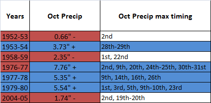
eta eta: not many warm Septembers for
weakmodoki ninos. 2004-05 is the only weak modoki nino +T Sep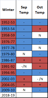
-
1 hour ago, showmethesnow said:
4 times a day? Pure madness I tell you. Pure madness.
Hopefully Levi gets access.
-
2 hours ago, showmethesnow said:
LOL. Nah, you caught me. Actually didn't look at the precip departures. Got so hung up on the 500's and following the torch in the arctic that I never even looked at them. Glancing over them now and December is probably indicative of systems running to our west and though the 500's are pretty zonal it does have the hints of troughing setting up in the west which would support that idea. Jan's precip departures look promising and its distribution would possibly suggest the threat of Miller A's? Considering that it is primo climo for cold it might not matter as much if the pv is farther north then desirable and the cold with it . Feb though I am not so sure the neg departures are result of suppression when you see the pv located so far to the north. Think the positive anomalies to our south are more a function of an active southern jet especially when I see + departures in southern Cali/Arizona into northern Baja. When I also see + precip anomalies just north of Maine I think the Cansips may be suggesting we see southern systems run off the SE coast and then turn up with the -Nao in place. Unfortunately it looks to favor a more eastern solution with that run up the coast so we are seeing the NorEaster's impacts much farther to the north bypassing our region. This would probably suggest that the Cansips favors an eastern based -NAO.
Weak ninos hit in Jan much of the time.
-
5 hours ago, 40/70 Benchmark said:
I posted this yesterday, guys.
http://easternmassweather.blogspot.com/2018/09/potential-2018-2019-analogs.html
The blocking signal from your analog package doesn't look so strong to me. Also, typo at the end... "Stay tuned as we continue to shed more light on winter 2017-2018 this fall into the winter-"
-
15 minutes ago, Maestrobjwa said:
That'll do it...lol (what is with their measurements, anyway??)
I personally believe nothing is wrong with their measurements. Urban environments can do wonders to ground temperatures.
-
1 hour ago, Bob Chill said:
Tricky contest this year. Easy to go late because well...it's been warm as F and warm enso is generally a mild fall pattern. Add is the ridiculous amount of saturated ground and everything points to a late start to cold season. However, a very cold Canada pattern looks to potentially lock in this month so intrusions could be pretty cold. Northern plains weenies may have a good October. Lol
Wait until after the deadline. lol
-
5 hours ago, Maestrobjwa said:
Yeah that is kinda weird...wonder what the total rainfall was for that year? (this year it just feels like it's gonna keep raining buckets...lol)
P.S. That 09-10 snowfall amount isn't quite accurate is it? Wasn't it like 70 inches or something? Lol
I also looked at September precip and this year blows away recent history. 2011's 8.84" is the only relatively recent year that comes close to September 2018's 9.73". On the flip side of things, high precip Septembers led to very low snowfall. I don't think they were nino year's though, making 2018 another anomaly.
-
5 hours ago, Maestrobjwa said:
Yeah that is kinda weird...wonder what the total rainfall was for that year? (this year it just feels like it's gonna keep raining buckets...lol)
P.S. That 09-10 snowfall amount isn't quite accurate is it? Wasn't it like 70 inches or something? Lol
They are DCA numbers.
-
3 minutes ago, Maestrobjwa said:
Dude I was just gonna ask if you could post an extended version of that chart, lol (I actually started looking up the precip totals myself...but had no idea which years were Modoki!) Thanks! Seems like 3.5-5 inches of rain is the sweet spot...lol (also interesting how we had a few instances of back-to-back Modokis....Wonder if that's setting up to happen again?...If so, our odds oughta be pretty good for either this winter, next winter, or both!

I was thinking the same thing about the 3.50-5 sweet spot! My question is how on Earth did
1977-781976-77 have such a high anomaly! -
I added more years and another column for October precipitation leading into Modoki El Ninos. October precip relative to average @ DCA may give a good estimate of how good a winter we get!
Modoki El Ninos (DCA)
Winter
SOI
Winter Snow
+/- Winter Snow
Winter NAO
Nov Temp
Dec Temp
Nov NAO
Dec NAO
Oct Precip
1952-53
Weak
8.3"
-
-
-
-
-
-
0.66" -
1953-54
Weak
18"
+
+
-
+
+
+
3.73" +
1958-59
Weak
4.9"
-
-
N
-
+
-
2.35" -
1976-77
Weak
11.1"
-
-
-
-
+ (N)
-
7.76" +
1977-78
Weak
22.7"
+
N (+)
+
N / (-)
N
N
5.35" +
1979-80
Weak
20.1"
+
-
+
+
+
+
5.54" +
1986-87
Moderate
31.1"
+
N
-
+
+
+
2.01" -
1991-92
Strong
6.6"
-
+
-
+
+
+
2.03" -
1994-95
Weak/Moderate
10.1"
-
+
+
+
N
+
1.19" -
2002-03
Moderate
40.4"
+
N
-
-
-
N
5" +
2004-05
Weak
12.5"
-
N
+
N
N
+
1.74" -
2009-10
Moderate
46"
+
-
+
-
+
-
5.71" +
-
 1
1
-
 1
1
-
-
DCA: 12/4
BWI: 11/4
IAD: 11/2
RIC: 12/1
Tiebreaker: 5.5"
-
It belongs here.
-
2 minutes ago, C.A.P.E. said:
This is also a discussion thread. It's relevant.
Where would you suggest it go, banter?
If it's less than 300, then probably the winter thread.
-
1 minute ago, C.A.P.E. said:
This is also a discussion thread. It's relevant.
Where would you suggest it go, banter?
I think you know the answer to that.
-
That was meant for C.A.P.E. Sorry V-R
-
1 hour ago, Vice-Regent said:
Keep dreamin'
")
Wrong forum thread
eta: 384 gfs does not belong in an obs thread
-
1 hour ago, mappy said:
rejoice weenies: Euro is coming to you four times a day, with 1 hour maps from 0-90hr, then 3hrs from 90-144
Any articles on this?
-
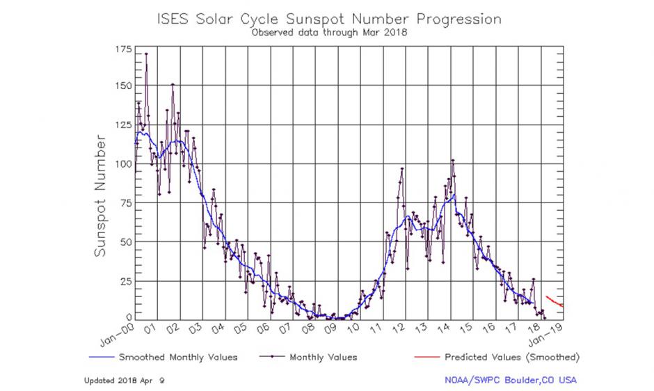
The sunspot numbers look promising.
-
1 minute ago, frd said:
Ah, OK, Ii was thinking of 2006 - 07 winter . I also came across this good summary as well , link below .
Per Ray, ( aka Benchmark via the New England Forum ) " First of all, while it was technically a modoki el nino, it only registered about a DM mean modoki reading +.33 on the scale, which is somewhat lower than where this event is projected to verify at near +.50. "
http://easternmassweather.blogspot.com/2018/09/weak-modoki-el-nino-imminent.html
I was wondering! 2007 is debatable for sure.
Winter 2018-19 Is Coming
in Mid Atlantic
Posted
What's interesting is when I compiled weak nino winters both good and bad snow seasons had negative October anomalies for our region. Then I tried the same for moderate good snow modoki ninos and got just what you said!
Moderate Modoki good snow
Weak Modoki good snow
Weak Modoki low snow