

BTRWx's Thanks Giving
-
Posts
3,026 -
Joined
-
Last visited
Content Type
Profiles
Blogs
Forums
American Weather
Media Demo
Store
Gallery
Posts posted by BTRWx's Thanks Giving
-
-
1 hour ago, Jakkel138 said:
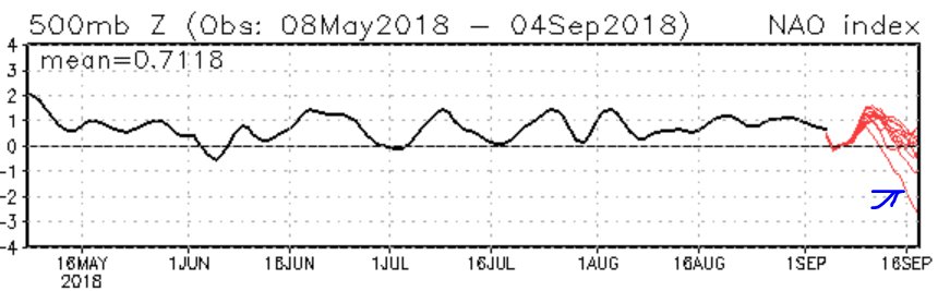
NAO might go negative by sept 16 or after. That outlier tho...
Another uptick first unfortunately
-
17 minutes ago, high risk said:
I'd love to hug that too, even as a fantasy, but in the meantime, I'll hug something that's actually in the short range: GFS and Canadian both show some pretty major cold air damming Sunday, with a rainy here and daytime temps in the 60s.
The euro has the cool air too.
-
 1
1
-
-
Just now, yoda said:
Thunder, lightning, and raining here now
thunder here
-
You know we could be in trouble when the GFS recurves everything while the euro is hinting at a hit down yonder.
-
The Weatherunderground map layouts look so bad now, especially for the tropics.
-
More summer evidence of fun times ahead!
eta: the blob returns
-
3 hours ago, Eskimo Joe said:
People who post the Farmers Almanac should be permanently banned.
Why? It's definitely relevant.
-
 1
1
-
 1
1
-
-
8 hours ago, BristowWx said:
Even if he did one no one would believe it anyway. Always expect disaster until it’s actually snowing.
I believe different years have different lead times. 2009-2010 was anticipated in July.
-
-
18 minutes ago, BristowWx said:
It was an exceptional synopsis. Great reference for those of us who didn’t know what QBO and MODOKI really mean. Seems like a regular Nino is not what we are really after. Good analogs in the mix with a couple of duds. We shall see.
30+ minutes of definitions

-
1 hour ago, WeatherLovingDoc said:
Hello americanwx experts! Will someone please post a model addressing the temperatures/weather over the next 5 to 7 days? What is it going to be like? That's why we come here to americanwx in part. Not just for storms, but for warnings and weather! Tyvm.
I'm confused what you're asking for.
-
JB, DT, FarmersAlmanac...yea, winter's coming!

-
This consistent rainfall has been remarkable considering how cool the Atlantic has been.
-
21 minutes ago, mattie g said:
Bottom of that line seems to be consolidating around MBY in east-central Fairfax County.
A lot of shear and scud
-
-
8 minutes ago, Maestrobjwa said:
Is there something about the region in particular that they can get 10-inch rainfall like this? (Wonder why it targets that area specifically like that). Or is this just a freak thing?
Any hypotheses?
-
6 minutes ago, Maestrobjwa said:
Is there something about the region in particular that they can get 10-inch rainfall like this? (Wonder why it targets that area specifically like that). Or is this just a freak thing?
I've read that downwind towns from uhi's can increase precipitable water. There has to be a lot more to it.
eta: I see Ellicott City is upwind
-
I just got my thunder on the back edge.
-
7 minutes ago, H2O said:
wow! Post them here!
-
1 minute ago, mattskiva said:
It was certainly severe in parts of the area - it seems like the storms may have weakened as they approached the metro. Loudoun, Fauquier and points west got it pretty good.
It was severe in Alexandria briefly.
-
It was a decent size storm imby, but last night was better.

-
2 minutes ago, alexderiemer said:
Seeing same but the velocity scan doesbt easily reflect that
Sent from my SM-G892A using Tapatalk
Could it be a microburst?
-
1
-
-
2 minutes ago, alexderiemer said:
The VIL on that Charles Town cell is off the charts!


Sent from my SM-G892A using Tapatalk
TVS in that area per radarscope
-
I wonder if the activity over central Virginia becomes the source for the metro action? There hasn't been much forward movement from the complex.

September Banter
in Mid Atlantic
Posted
When was our last tc landfall leading into a favorable winter?