

BTRWx's Thanks Giving
-
Posts
3,026 -
Joined
-
Last visited
Content Type
Profiles
Blogs
Forums
American Weather
Media Demo
Store
Gallery
Posts posted by BTRWx's Thanks Giving
-
-
Like I was mentioning earlier, the high is retreating way too fast.
-
We're going to need a better high placement to score.
-
 1
1
-
-
Does the euro start early tonight?
-
The last frames are taking forever to load.
-
Para is south of the op with the low with less snow, but it shows snow!
-
"Boy it's empty here". Oh wait, new month, new season!

-
1 hour ago, Snowlover101 said:
Good way to say it, but why did he share the snow maps?!
-
It's notable that we torch 1 weekend before a weekend #ecs potential.
-
8 minutes ago, pasnownut said:
My nooner takeaway....
IF you take a blend of GFS and EURO, its still a decent track, which is all i worry about right now.
d8
-
Why does it have to be day 8?!

-
The MJO ensembles have weakened considerably unfortunately.
-
5 minutes ago, Tenman Johnson said:
Required Negative Attitude
Here's a closer answer with some science basis. https://www.sciencedaily.com/releases/2017/04/170406171917.htm
-
1 hour ago, AfewUniversesBelowNormal said:
Remember, it's still +PNA now where it's been since July. It's very unlikely that we go into such an extreme RNA pattern. Models sometimes have a bias here. Although with RNA they sometimes don't. It doesn't fit though.
What's RNA?
-
I'd expect forecasts to adjust as the mjo signals improve.
eta: One thing to look out for is the phase 1 weak warm signal for OND. http://www.cpc.ncep.noaa.gov/products/precip/CWlink/MJO/Composites/Temperature/
-
5 hours ago, losetoa6 said:
Fridays possible little system seemed dead but going thru Eps members...they all of of sudden have a sizable uptick in the snowfall for that time period. Eps wanted absolutely nothing to do with this potential till now. Now...we r not talking anything mod to big but a nice big cluster has 1/2" - to as much as 2" . And the mean up to 1/2" for north of i70. Surface temps look to be marginal and probably stale cold air but maby we can at least resurrect some snow TV or some mixed precip out of this .
The end of the run of the eps looks very promising too.
-
Keep a close eye on the MJO!
-
 3
3
-
-
1 hour ago, Bob Chill said:
Check out the d14 AO verification. Gefs is busting high in the long range. This is the exact opposite of the last 3-4 years. We're moving into prime time for the AO to be a meaningful long lead indicator. If the gefs keeps busting high then good things are probably about to start happening no too far in future. Like in 2 weeks...

What you said there is significant!
-
Jeopardy just asked a question about the Planetary Boundary Layer!
-
2002-2003 is looking better every day.

-
1
-
-
4 hours ago, C.A.P.E. said:
Looking at all the current guidance, the reality is Dec will probably be pretty changeable. Still have to think the NPAC will get "right" at some point. AO looks good for now. I don't see much to worry over yet. This is a relatively late starting Nino (compared to say 2009 when official Nino status was achieved by August IIRC), so just a guess on my part, but it may take some time before the atmosphere completely responds and locks into more typical Nino behavior. Most of the winter forecasts were indicative of that, with things really getting going in January.
It's interesting to have the Modoki signal along wiht the north Pacific warm ssta blob. That's rare.
-
6 minutes ago, Thanatos_I_Am said:
This Colt McCoy offense is just... uninspiring.
So is the overrated D
-
1
-
-
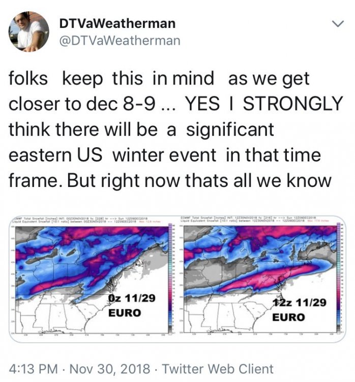
We're getting a little of Cali's smoke plumes.
https://twitter.com/GarySzatkowski/status/1064623827626442757
-
5 minutes ago, LeesburgWx said:
Still snowing here! Over 3 inches and counting!
calling Ji (didn't think 3 was possible)
-
1
-
-
11 minutes ago, Maestrobjwa said:
So hang on...is it actually a sure bet now that it's going to tank?
I'd say so!


December Medium/Long Range Discussion
in Mid Atlantic
Posted
No, I'm stuck with ttb maps.