

BTRWx's Thanks Giving
-
Posts
3,332 -
Joined
-
Last visited
Content Type
Profiles
Blogs
Forums
American Weather
Media Demo
Store
Gallery
Posts posted by BTRWx's Thanks Giving
-
-
3 minutes ago, Kay said:
NE MD
PUMMELED
Georgetown too
-
 1
1
-
-
MaxVelocity just said Kansas City is under-performing. Maybe they got more ice?
-
4 minutes ago, nj2va said:
Nice fetch coming up through Louisiana.
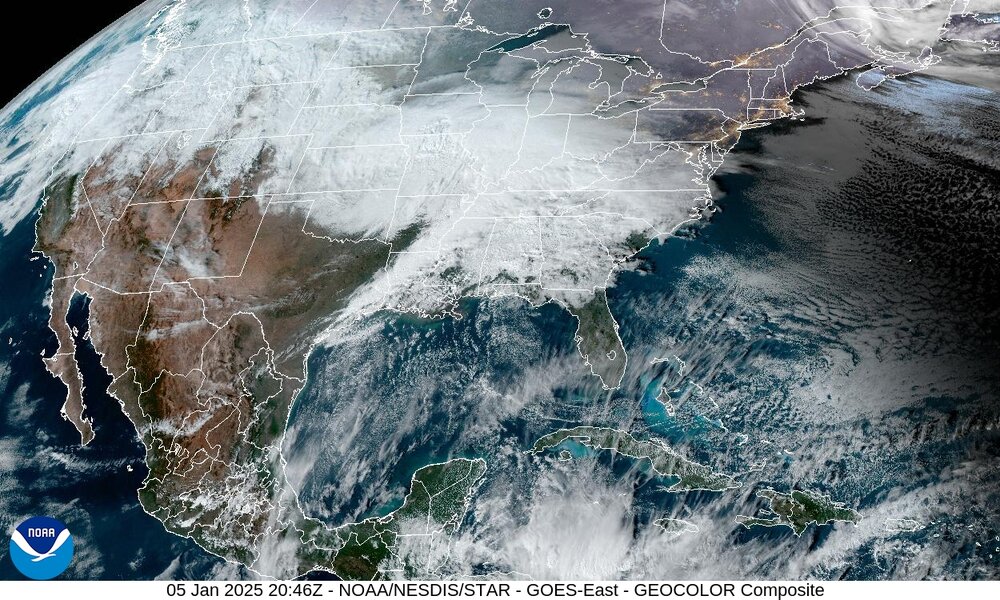
I can't remember ever seeing continuous cloud cover from the west coast to east coast!
-
DT has been bashing Wakefield.
-
3 minutes ago, 300 square feet said:
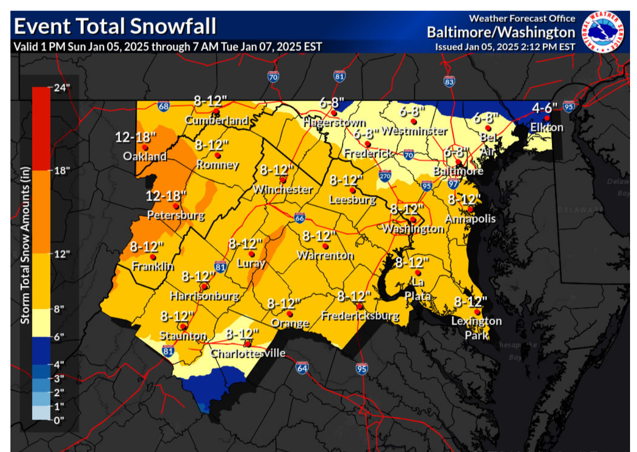
New totals from LWX!
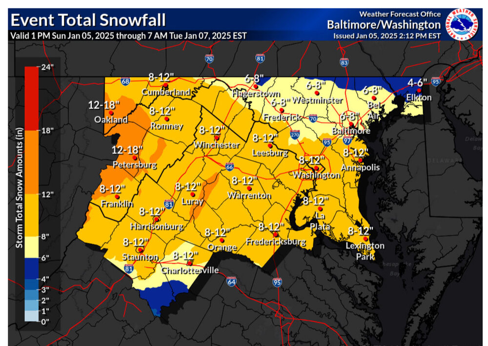
I see 6-12 for some reason.
-
4 minutes ago, snowfan said:
Put your snow obs here….
Leftover coating from Friday slowly melting.
-
Looks like a very slight shift south with the heaviest precip.
-
Slightly later arrival on the 12z euro compared to 0z.
-
Just now, BristowWx said:
Wxman1 is a favorite of mine. The name says it all. Number 1. He knows shit.
I think you are missing a word. lol
-
1 minute ago, snowmagnet said:
Millville seemed right on target 3 days ago with his forecast of 8-12” for much of the area. All the models agree with the DMV being in the bullseye.
Same with DT
-
1
-
-
Are we calling it a SECS?
-
2 minutes ago, TSSN+ said:
Don’t see much of a change there at all.
Purples expanded
-
54 minutes ago, brooklynwx99 said:
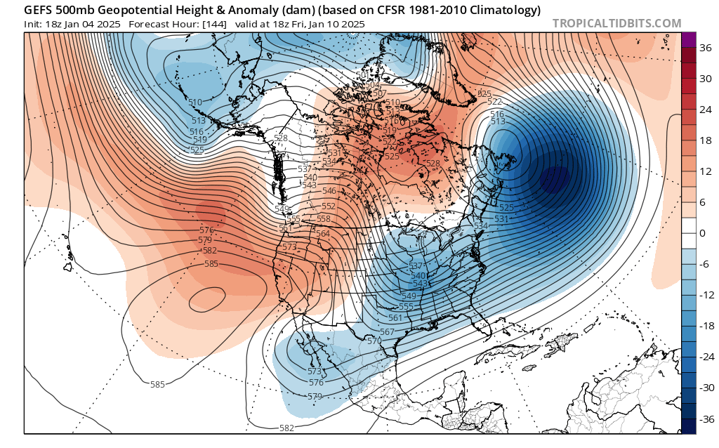
this has pretty much every box checked off synoptically: phasing trough over the OH Valley, decaying west based -NAO, huge, slow moving 50/50, and antecedent cold air
just a matter of how it all comes together

What a weird western ridge orientation.
-
1 minute ago, Wetbulbs88 said:
True. And I don't discount the NAM completely like some others. HRRR on the fringe somewhat but getting into range.
Others are more experienced.
-
Just now, stormtracker said:
Anybody else notice any huge differences?
I see the Low quite a bit south compared to 6Z.
-
1 minute ago, clskinsfan said:
LP off VB is tasty.
Would a precip field expand that far west if the low is that far east?
-
1 minute ago, Weather Will said:
WB 3K NAM through 3pm Mon.


The snow map is the hrrr.
-
1
-
-
1 minute ago, jayyy said:
Reasonable to give a range given some of the uncertainties we face. Seems like they considered our local climo and a blend of models for that call.Forecasts are always a range.
-
Snow on snow on snow on snow on snow on snow on...
-
1
-
-
4 minutes ago, bncho said:
CWG goes with 5-8" for DC.
Their boom/bust scenarios are very realistic.
-
1 minute ago, weathercoins said:
CWG teasing that they’re about to up their snow totals (last map they had was ok I thought) https://x.com/capitalweather/status/1875615910687559981?s=46
That's not what they said. It could be simply tightening the boundaries.
-
3 minutes ago, Master of Disaster said:
Did some research this morning. The last plowable snowfall event of 4 to 8 inches for DMV was Jan 3rd 2022. They are well overdue for a good storm.
We had one last year of about 3-4", but nothing like this.
-
 1
1
-
-
1 minute ago, brooklynwx99 said:
also this exact event is why people shouldn't fret over ENSO. some of you guys might have half of your yearly average by Jan 6 while north of 78 smokes cirrus as we're heading into a favorable pattern. I kinda love the irony
My new favorite pattern is a +TNH/+PNA combination!
-
2
-
-
10 minutes ago, Weather Will said:
WB 15Z NBM.

So NBM is going against the euro?


January 5-6 Thing Storm Obs
in Mid Atlantic
Posted
Was that a TNH pattern?