

Thinksnow18
-
Posts
4,144 -
Joined
-
Last visited
Content Type
Profiles
Blogs
Forums
American Weather
Media Demo
Store
Gallery
Posts posted by Thinksnow18
-
-
9 minutes ago, rochesterdave said:
I’m still pretty confident we don’t have mixing (and if we did it would be for a minute) but I guess it’s a limiting factor we need to watch.

It might be why the deformation zone is over WNY is that’s where the best lift will be and copious amounts of Atlantic moisture which could be sneaking in Atlantic air
-
53 minutes ago, lakeeffectkid383 said:
06z RGEM looks good as well.

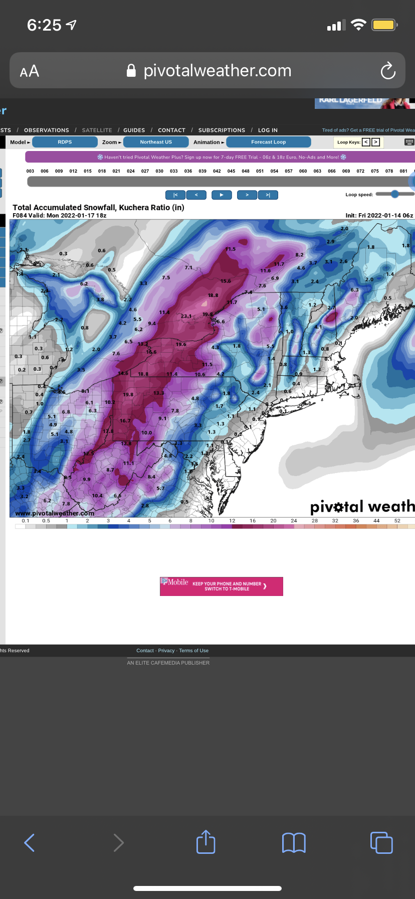
At this point we might be able to start discussing this as an all time event for the Niagara frontier. Someone in that region will get 2 feet.
-
16 minutes ago, Flying MXZ said:
The first map I think I've seen. He's definitely more of a mid-atlantic forecaster, but I'll take my 6"-10" in our snowhole.
That map is horrible. It’s pretty much a normal “chalk” map as how systems would act with climo. Not certain what that poster is seeing but that remarkably less snowfall than any other model out there. Toss.
-
 1
1
-
-
1 hour ago, tim123 said:
Watches are up.
Yes a bit earlier than I thought yesterday but with the overnight and the 6z model runs really looking the same the NWS is starting to use the word likely instead of possible heavy snow.
-
2 minutes ago, BuffaloWeather said:
I think this is what you're referencing? Look at sounding and 2m temps, that is heavy snow not a mix.
Just checked bottom right and says precip type sleet. I don't think I've seen sleet at 20 degrees before?


Especially with the low over Maryland!
-
1
-
-
25 minutes ago, Leelee said:
KBUF and every TV met here is like "nor'easter, maybe a heavy snow, we might get brushed by it". Even the usual big hype ones like Cejka are like whatever so far. Weird for a synoptic storm with this potential.
Todd was much more on top of it tonight at 7. He even mentioned not trying to scare anyone this far out but said it looks good for a widespread foot for WNY and the potential for an area within to double that. For Todd that’s as hyped as you’ll see. As for Mike he’s been really off his game lately. This am he had snow showers and light snow while ALL models were already showing this scenario. He was also off badly with the lake effect last week as well
-
1
-
-
Needless to say this storm has epic possibilities for WNY, but the whole run of the GFS is still incredible. It’s been mentioned today a few times but it goes to say this has potential for a very special 2 weeks.
-
Watches just issued for western North Carolina, western Virginia and West Virginia. The storm fir that area is 48-60 hours out, which means by tomorrow at this time we will also have watches hoisted.
-
2
-
 1
1
-
-
1 minute ago, DeltaT13 said:
I'm not trying to poo poo anything as this storm is honestly one of the best looking systems for Upstate that I've seen in the last couple of years, I just think it's wise to keep expectations in check right now. I think a solid 12-15 storm would be pretty damn fantastic.
I agree. I do think as far as timeframe we are over due in WNY for a storm like this.
-
4 minutes ago, rochesterdave said:
Usually I’d agree. But if we get this track, id put my $ down on 2 feet.
Stamped and saved…
-
 1
1
-
 3
3
-
-
IF trends continue I’m guessing with the magnitude of this system watches hoisted tomorrow afternoon?
-
1
-
-
42 minutes ago, wolfie09 said:
.thumb.gif.b7e5e203fe24d543f85025ed579cdf1e.gif)
Death band over WNY
-
1
-
2
-
-
6 minutes ago, Syrmax said:
WPC clearly skeptical of the WNY/WPA jackpot scenario.
Because far too many, as I see it, go climo with alot of their forecast and are skeptical when anything else pops up
-
3
-
-
13 minutes ago, rochesterdave said:
100% We need this to be on the east side for however briefly. It won’t cut back across. Danger is if it starts up on the west side. Then we are screwed.
I’m pretty certain this is setting up to be a classic Miller B storm. Primary goes into western PA and gives way to a much stronger east coast/inland runner that sends copious amounts for most of Upstate. Why this will work as opposed to the damn good tracks in Nov and Dec is now we actually have a large pool of arctic air just to our north. I’m pretty confident (I know I’m setting myself up for the Dave repost) that this is what the models will hone in on
-
5 minutes ago, tim123 said:
Far western ny buffalo niagara need a true apps runner. Rochester syracuse apps runner or a coastal inland up Hudson Valley area.
Last app runner I can remember was Jan ‘05. It’s the same day my wife and I found out we were going to have our first child. Great day all around.
-
4
-
-
1 hour ago, tim123 said:
Looks like ens shifted west on euro.

Yeah that’s ALOT of land lows
-
1 hour ago, Syrmax said:
As a Giants fan...i wouldn't exactly be dishing from a position of strength...
")
actually you would get as Tommy lost twice to you! It was hilarious on the manning cast a few weeks back where Peyton and Eli had Tom on and Eli was ribbing him good.
-
1
-
-
59 minutes ago, BuffaloWeather said:
Bills forecast, I'm going to freeze at the game. Definitely favors the Pats, Allens hands going to freeze.
Saturday NightMostly cloudy, with a low around 3.I was at the Cleveland Monday night game about 10 years ago and the temp was the same. It didn’t mattter what I did as by the 4th it was just numbing.
-
1
-
-
13 minutes ago, BuffaloWeather said:
easy pass, cold and dry patterns are my absolute least favorite.
Agreed. However, if the PV is that close one would think there’s bound to be multiple S/W imbedded that are not yet detected
-
Normally on these threads we don’t speak about temps as a topic of conversation…however that’s going to change right now. The Euro output for temps next Tuesday-Wednesday look to be absolutely brutal If correct. Lows would approach -10’ at LOWER ELEVATIONS and -20/-30 in the normally colder higher elevations and valleys! Damn!
-
 1
1
-
-
7 hours ago, SouthBuffaloSteve said:
where did you get that? I barley got a dusting here. line fell apart right over the city and once it got to me she was all dried up...
It was the heaviest snow I’ve seen maybe in my lifetime. I’m north of the thruway by about 3 miles.
-
2.1” in roughly 40 minutes. That’s nuts.
-
2
-
-
13 minutes ago, DeltaT13 said:
That was incredibly heavy snow, wow! Honestly way heavier rates than anything I saw in Buffalo the other day. I was getting lost and disoriented on roads I’ve been on 100 times. 10 foot visibility at best during the peak. Really impressed. That was worth the price of admission. I took a couple vids but the camera does a great job of filtering out scattered light and noise so never really looks like much. I’ll see if any are decent after I eat.
Agreed. I am out picking up my son and if this isn’t 3-4”/hr snow I’m shocked. Absolutely ripping
-
The 12z has the first clipper over the weekend still diving into South Carolina, probably onto something, but as BW eluded to a few posts ago, Wednesday, Friday and the following Tuesday all look like opportunities for LE in the Metro area. I think the synoptic goes to shit but the lakes save us over the next 2 weeks. They’ll have to because they’re about to freeze quickly

.gif.d607d65d8f4f087cfd18331d217ba314.gif)

Widespread Snow Potential January 16th to January 18th
in Upstate New York/Pennsylvania
Posted
Toss.