

Thinksnow18
-
Posts
4,144 -
Joined
-
Last visited
Content Type
Profiles
Blogs
Forums
American Weather
Media Demo
Store
Gallery
Posts posted by Thinksnow18
-
-
42 minutes ago, wolfie09 said:
Moderate to heavy lake snows remain locked in place across Oswego
county late this morning...`behaving` quite well with the forecast.
While the activity has become a little cellular this morning...feel
that with a stronger upstream connection this afternoon...the band
will consolidate a bit and push north by miles or so. This is where
the RGEM has been anchoring it for several days now...and as no
surprise...is where the new 12z run of the NAM takes it.
The NAM…the black sheep of all models
-
 2
2
-
-
2 minutes ago, wolfie09 said:
I think the area that will JP will be just south of here, parish, mexico, maple view etc..The band will go through that area late this evening once again..I still yet to see much northern movement which kbgm alluded to..


Wasn’t it Parrish and Mexico about a decade ago that got absolutely demolished to the tune of over 100” over like a 3 day period?
-
Parade of accumulating clippers on GFS especially this weekend. That’s the type of pattern where we nickel and fine our ash over a week or do to pretty healthy snowpack across all upstate…plus that COULD be a Bills home playoff game
-
 1
1
-
-
21 minutes ago, lakeeffectkid383 said:
Not lake effect rain, that’s the front moving through. Still rain none the less but not lake effect.
Damage done anyways. Lost most of our snowpack save for the plowing sand piles…and now the euro lost thaw weekend storm…2 weeks of dry would suck fiercely
-
 1
1
-
-
Just realized the metro Buffalo area has a lake RAIN band over it…that’s just cruel
-
19 minutes ago, wolfie09 said:
Gfs12z has hardly anything over the next 10 days besides tomorrow obviously..
It’s close to next weekend. You can see it trying to firm something. Give it a day or two
-
2
-
-
1 hour ago, TugHillMatt said:
Yuck. Wow, you had ten inches, right? That fluff gets obliterated quickly; especially with rising dewpoints, which I see are in the upper 30s there.

That 10” was really down to about 4-5 after 1 day or do with how much air was in it. It settled quickly and the ground beneath wasn’t completely frozen so I noticed it was soft snow near the ground. Add it up and we subtracted a lot.
-
4 minutes ago, tim123 said:
True euro actually was better with that storm.
So there’s a chance?
-
1
-
-
4 minutes ago, TugHillMatt said:
The low elevation of the lake plain and its connection to the torrent of warmth that moves up the west side of the Apps kills me. Low 40s out in Western NY while it's an Ice Storm 100s of miles to the SE.
How's your snowpack holding up? Mine has compacted to 6 or 7 inches.
Lucky to have 2” of absolute slop that’s going to turn into a glacier overnight. Will look absolutely putrid out until we can get some fresh on top
-
1
-
-
43 minutes ago, 96blizz said:
This was the 0z Canadian for Sunday AM posterity. The GFS doesn’t see it but 2 out of 3 ain’t bad at this range. With next weekend being a 3 day weekend for many, it would be fun!
This gives me pause. The GFS has been the superior model to this point so far. Hopefully the CMC and Euro are in to something more substantial as I watch a good chunk of the 10” snows I received wash down the drain.
-
54 minutes ago, BuffaloWeather said:
The medium to long range is about the best you can ask for for Upstate. I mean look at this, ridging in the west and good NAO blocking with the PV north of Hudson Bay to provide consistent cold air. It doesn't get any better than that, especially for Ontario posters as in this type of pattern Lake Erie will be mainly frozen by start of February, we have about a month left of Lake effect potential off Erie. Off to play ice hockey, will be a fun next few weeks!


We score another LES event in the metro with that pattern.
-
1
-
 1
1
-
-
2 hours ago, wolfie09 said:
The euro trying to get something going one week from today..
.thumb.png.87a8b0d59a2d2d780384657dc5145045.png)
.thumb.png.695dbddf48965ad357982bc03a5a2276.png)
Miller B
-
1
-
-
1 hour ago, lakeeffectkid383 said:
4.1” overnight. Still snowing.
Good for you Devin!
-
Just now, rochesterdave said:
Looking at this, you gotta figure someone gets hit

Heavy snow in Williamsville right now with a plume off Huron! Big fluffy dendrites and the band looks stationary
-
1
-
-
1 hour ago, LakeEffectKing said:
From BUF NWS FB page:
....looks like a coupon I should clip...
")
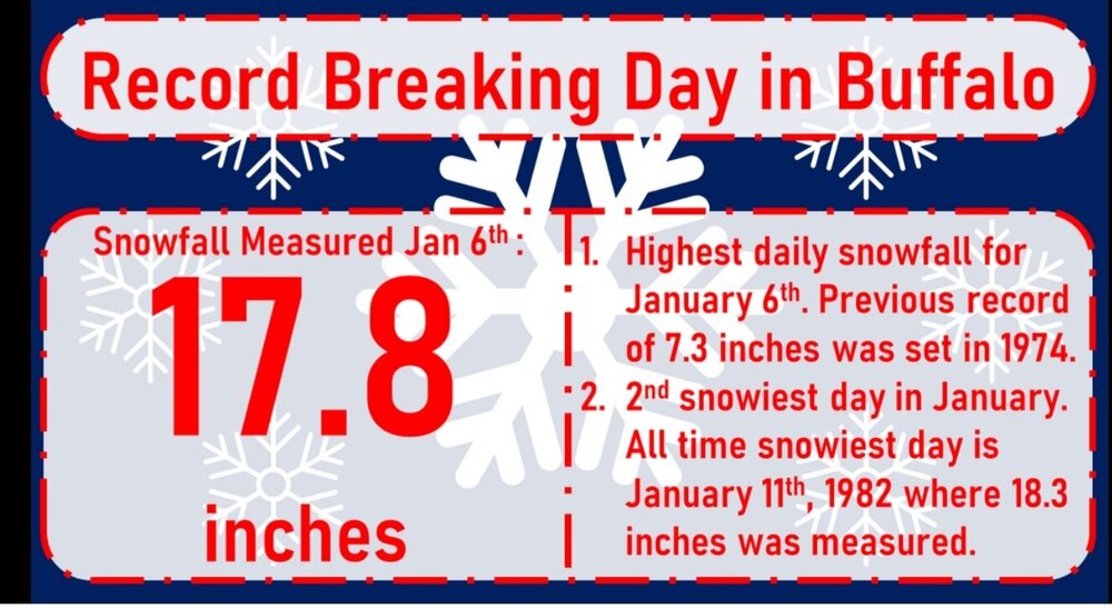
Wait, second only to January 11th 1982? Didn’t the Blizzard of ‘85 have a say in that? Never mind I see it was .9” more. I will say two things stick out to me about that list of top 20 snowfalls at KBUF…there will never be another stretch like we had in December Xmas week, that’s a unicorn and March 17th 1936…that must’ve been one hell of a synoptic storm as there was zero chance that was lake effect.
-
Not sure if it means much at this point but the western end of Lake Erie has really blossomed in the past hour, and what seems to be a SSW trajectory?
-
I just posted on the other thread regarding the 18z GFS a bad the amount of opportunities over the next 24 days…digging deeper, KBUF, I believe, was 25” below average for the season snowfall. We almost made that up today. By the end of this run, We could be seeing above average positive anomalies. That’s amazing considering where we were at.
-
1
-
-
3 hours ago, Ericjcrash said:
That's cool, but no snow. Maybe get a lingering streamer this weekend
Did you see the 18z GFS? It was chance after chance. Nothing huge but with 2 weeks of solid cold it was all snow and there are some details to work out in the long range but some are close to big systems.
-
1
-
-
Just now, Buckeyes_Suck said:
We really need just a little stronger flow. I’d prob get to 30” tonight.
I just realized something. I have sat down for the moment after rearranging some furniture and realized there’s a Sabres game, my dog is limping and my wife got her nails done…I am a weenie through and through…
-
2
-
-
5 minutes ago, Buckeyes_Suck said:
No I’d expect a nw flow…
Congrats today! What’s your total? I measured 10.3 so far and still flurrying to occasionally light snow
-
3
-
-
4 minutes ago, Buckeyes_Suck said:
No I’d expect a nw flow…
Agreed this is very strange…especially as Delta pointed out last evening when he mentioned our best setup is a closed low over superior or just a bit north of that.
-
Moderate snow and the lake is really getting its act together.
-
38 minutes ago, BuffaloWeather said:
Quite a few more yellow returns popping up as it slowly drifts south.
Odd the heavy returns are right over and yet it’s light snow…
-
3 minutes ago, BuffaloWeather said:
Thats where im headed to shovel my grandmas and aunts driveway.
You’re about to get into some heavy returns!!! Enjoy!!!
-
1
-


.png.d0ca475873d24c5d57a74fe625066a2e.png)
.png.44f47e1cb5fb3a167d3377ef43a04796.png)


Upstate/Eastern New York- Jan 9-11 Lake Effect Snow Event
in Upstate New York/Pennsylvania
Posted
Ok 3 things about that clip, 1) always liked Sharon Resultan, maybe crush like, 2 the reporter said north of Watertown, clueless there and 3 how deep the cold was getting all the way the the Carolina’s so much that DC had a high of 20! When’s the last time that’s happened to them?