

Thinksnow18
-
Posts
4,144 -
Joined
-
Last visited
Content Type
Profiles
Blogs
Forums
American Weather
Media Demo
Store
Gallery
Posts posted by Thinksnow18
-
-
Snow approaching 1”/ hour rates….heavier jest west coming in…
-
 2
2
-
-
Just now, BuffaloWeather said:
Added a 18-24" stripe across the airport and just south
That 12-18 got a lot further north. Is almost to the 990. Snowing moderately here now but flakes are small, some bigger mixing in.
-
Just read the AFD update and they aren’t expecting the band to shift south until midnight?!?!?! Damn…
-
Just now, BuffaloWeather said:
Here comes round 2. I would think sometime between 4-8 we will get our strongest band. Widening and drifting south. Still not nearly as intense as earlier today.
Wonder if it becomes multi-banded?
-
55 minutes ago, Thinksnow18 said:
You can see the band re-organizing over the eastern end. Expecting heavy snow in the next 30 minutes to an hour
Those heavy returns over the lake and the Niagara Peninsula are headed right towards Williamsville.
-
1 hour ago, BuffaloWeather said:
Band made it up to Grand Island
You can see the band re-organizing over the eastern end. Expecting heavy snow in the next 30 minutes to an hour
-
1
-
-
1 minute ago, BuffaloWeather said:
One of my buddies lives in Grand Island, band definitely weakened quite a bit.
Looking upstream it appears the wind direction at Grand Rapids is WSW still. Wondering how far the band stops after this S/W
-
2 minutes ago, BuffaloWeather said:
Band made it up to Grand Island
Yep north of Williamsville already…about 6” OTG
-
1
-
-
Very heavy snow in Lancaster at the plant eyeballing a foot…looks like band is shifting north again.
-
2
-
-
Looks like the band us oscillating a bit north over the lake again. Great call BW!
-
 1
1
-
-
2 minutes ago, BuffaloWeather said:
Wb ayuud! You should get hit good with this one.
He’s gotta be pounding right now!!! I’m at Clarence ctr re where it becomes Stahley at the Conner rd split…(Buckeyes Suck will know where that is) and the snow is picking up again. OTG here about 4”
-
1
-
-
12 minutes ago, BuffaloWeather said:
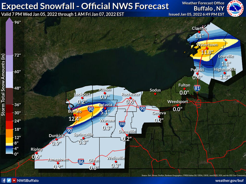
Told y’all yesterday this is Buffalo north event. 2’ at Kbuf today
The models ended up being right. The ones you showed late last night.
-
1
-
-
32 minutes ago, BuffaloWeather said:
That stuff near Clarence is 3”+ per
I can confirm. Took me 30 minutes to get to the plant which normally takes 14 or so…Lancaster has about 5” still snowing heavily but I think the heaviest returns are just north. Was pouring snow when I left my house at 610. Wife says we have almost 3” since I left.
-
2
-
-
18 minutes ago, lakeeffectkid383 said:
New NWS map really cuts back totals for here, looks more realistic IMO. About 6” here according to the map which is about what I’m expecting here.
Winds are out of the west. Lake effect is on a east-west trajectory at the west end of the lake…is this a bust already? The warning started at 7 and the band is NOWHERE near forming.
-
1
-
 2
2
-
 1
1
-
-
BW have you looked at your point n click? All of them are remarkably different and not in a good way
-
Just now, Thinksnow18 said:
That’s in a trajectory for northern Erie.
That’s very intense already in the middle of that band and it’s only west end of the lake!!! That’s headed right now seemingly for long point…it may be near southern Niagara at this trajectory
-
25 minutes ago, BuffaloWeather said:
As I was posting lol

That’s in a trajectory for northern Erie.
-
15 minutes ago, Buckeyes_Suck said:
Probably has more to do with ability to implement remote learning.
None of the schools are…just closed.
-
5 minutes ago, DeltaT13 said:
Amherst, geez...they are on the hairy edge of getting zilch (IMO), that is before tomorrow at least. Perhaps later tomorrow or tomorrow night when the next shortwave approaches they might get in the game.. Anyway, that was a bold call.
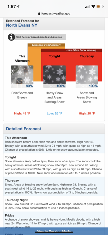
Local Mets and NWS has that area into the 4-8” zone, my area 8-12 but right on the edge of 10-18
-
3 minutes ago, DeltaT13 said:
Amherst, geez...they are on the hairy edge of getting zilch (IMO), that is before tomorrow at least. Perhaps later tomorrow or tomorrow night when the next shortwave approaches they might get in the game.. Anyway, that was a bold call.
I agree. I feel Williamsville where I live and my kids go to school is more primed for better numbers. Amherst central is near Snyder about 8 miles from here due west. My house neighborhood is near maple and transit roughly 3 miles north of the airport.
-
12 minutes ago, BuffaloWeather said:

Schools dropping like flies…Amherst, Depew on top of BPS…and my kids were just told Williamsville CSD closed
-
Grand Rapids wind still out of the SW…that bodes Really well here
-
58 minutes ago, BuffaloWeather said:
Last runs before the fun starts. Max total right near KBUF

Channel 4 STILL has the band nowhere near the metro until 10am tomorrow…yet somehow they have the whole metro and northeast in the 4-8” category…their “in-house” needs an upgrade
-
13 minutes ago, lakeeffectkid383 said:
9-17” at my house but I’m not sure I buy it.
It appears you get more Thursday night. I’m at 3-7 tonight and tomorrow and 1-2 on Thursday night


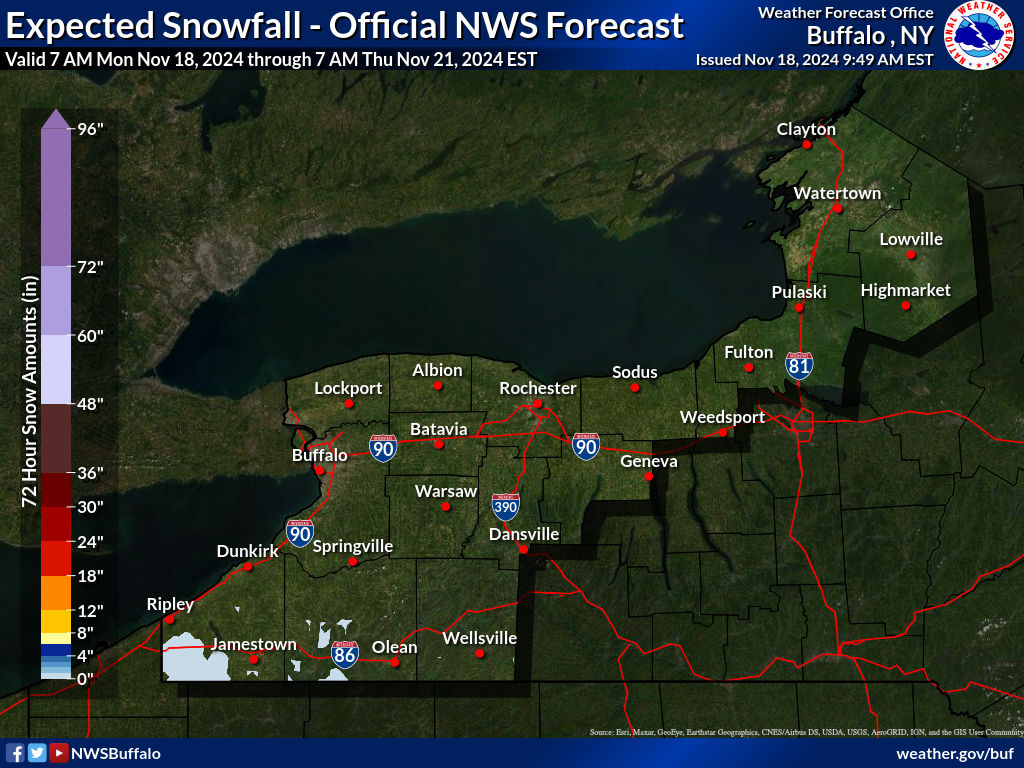
Upstate/Eastern New York- Jan 5-7 Lake Effect Snow Event
in Upstate New York/Pennsylvania
Posted
Some heavy 2”+ over the north part of the metro heading NE…I can see many areas over a foot with KBUF to Lancaster 2’